#7 Satellite Imagery Revelations: Tracking the Evolution of Two Chinese Settlements on the Contested India-China Border
TL; DR
Significant recent developments have occurred in two border settlements, one in Zone A (an unnamed village) and the other in Zone B (Migyitun, Longju, and Luowa).
Structures with dual purposes are being constructed in Zone A on the boundary line specified by the Survey of India (SOI).
Since 1950, Zone B, a contested area, has experienced numerous construction projects, with a notable one in 2020, as indicated by the Pentagon. Additionally, several more construction projects have occurred in the last three years.
1. Backstory
In our recent research of border settlements, particularly the 'Dual Purpose Settlements' located within 100 km of Tibet from the Indian frontier, we've uncovered a few notable findings on the Arunachal Pradesh border line provided by the Survey of India. The vector boundary line referred to here is used to demarcate between two countries by all major geospatial service providers in India.
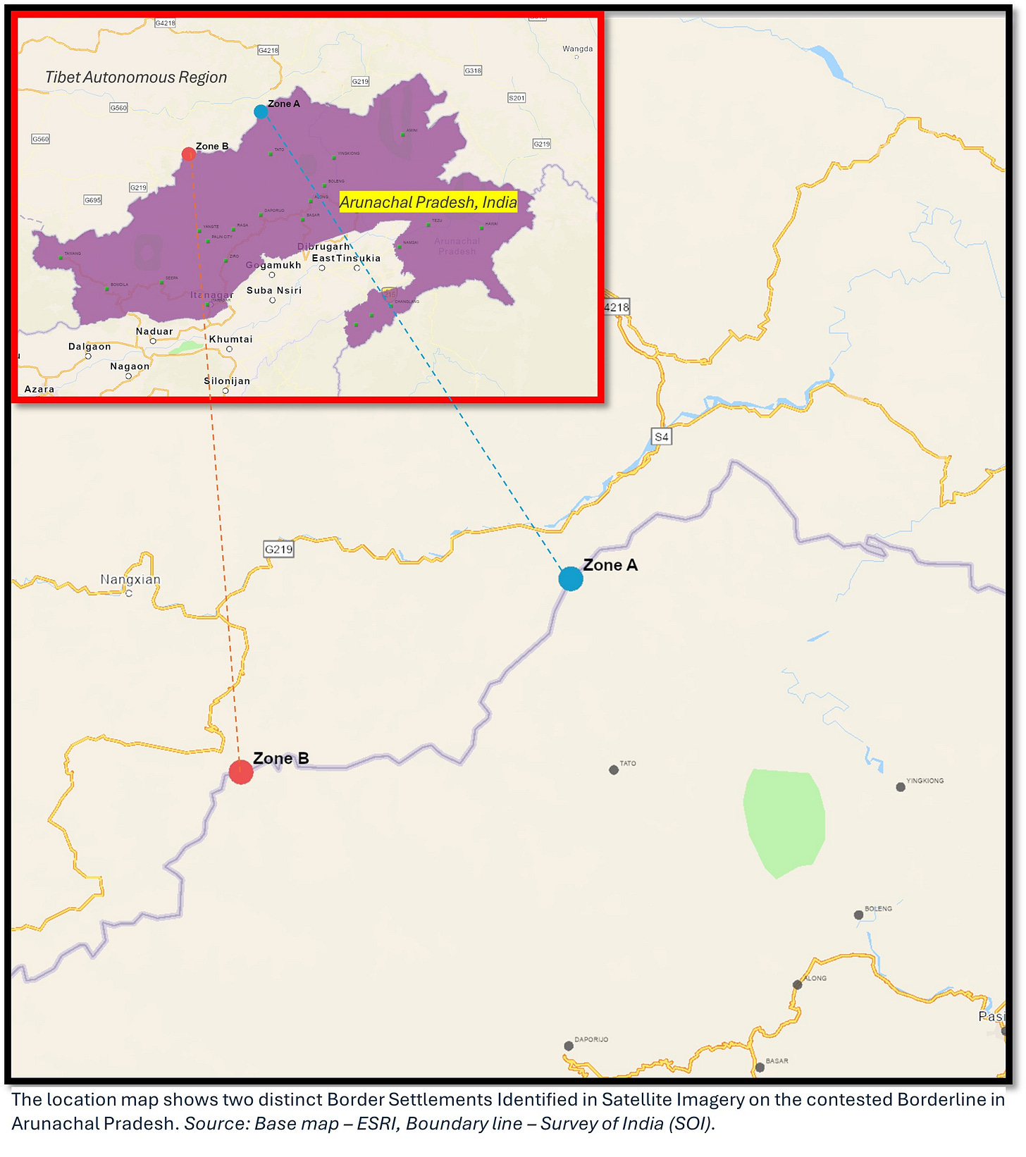
This article delves into a comprehensive analysis of two specific locations, Zone A and Zone B, in the following maps, where the Chinese border dual-purpose settlements are evident around the established boundary lines. Utilizing advanced remote sensing algorithms, we initially mapped these areas. Subsequently, we referred to high-resolution satellite imagery to conduct an in-depth study. Temporal satellite images played an essential role in uncovering the direction and growth of settlement expansion, the types of developments, and the presence and features of military infrastructure. This work aims to track and comprehend the changes and growth patterns over time through satellite imagery, providing a distinct perspective on the dynamics at these crucial border areas.
This study systematically tours a series of recent developments in the zones since 2020. While Zone B has been in the news in the past, Zone A is largely unnoticed.
Zone A—an unnamed border settlement on the Millin River—is the most recent ongoing settlement development on India’s claim line, which started in 2023.
Meanwhile, Zone B—Migyitun and its surroundings—have been disputed since 1950; the Chinese occupation has expanded its presence in the valley since 2020. Zone B has three important sites: Sites I, II, and III.
2. Mapping the hot zones around the critical line
Zone A is located on the banks of the Milin River, approximately 65 km west of Tuting, Arunachal Pradesh, India, and 15 km south of Mainling, Tibet Autonomous Region (TAR). Meanwhile, Zone B is located on the Tsari River, approximately 50 km northwest of Nacho, India, and 53 km southeast of Nang County, TAR. It is steeped in historical significance and has been a contested territory for many years. Both zones are located on the valley slopes towards India.
2.1 Zone A: An unnamed border settlement on the Millin River
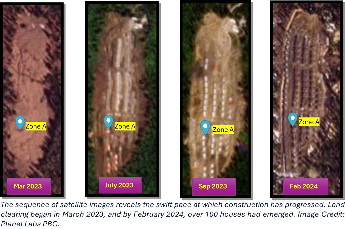
Zone A is situated on the western bank of the Milin River, a tributary of the Yarlung Tsang Po. Right on to the contested boundary line lies a small, barren patch of land spanning 0.11 sq. km. It remained empty with two shelters for decades until recently, when it transformed remarkably into a border settlement. A rapid construction activity has been underway since mid-2023, with nearly 100 structures emerging in a few months. This settlement, nestled amidst forests and rivers and conveniently located near a road, rests on a mountain slope at an altitude of 3142 m. From the satellite image, the ongoing development is advancing rapidly and is in the final stage.
Notably, comparable open pasture lands can be found in other sections of the mountain slopes in the vicinity on either side of the borderline. These areas can potentially be utilised for similar development projects in the future. They are expanding the road network, extending further south along the river, which bolsters this prospect, suggesting the possibility of further development in these regions.
2.2 Zone B: Migyitun and its surroundings
Table 1 provides an overview of three sites located in Zone B. The information provided here is extracted from remote-sensing images.
*Longju is a disputed area with a history that dates back to 1950.
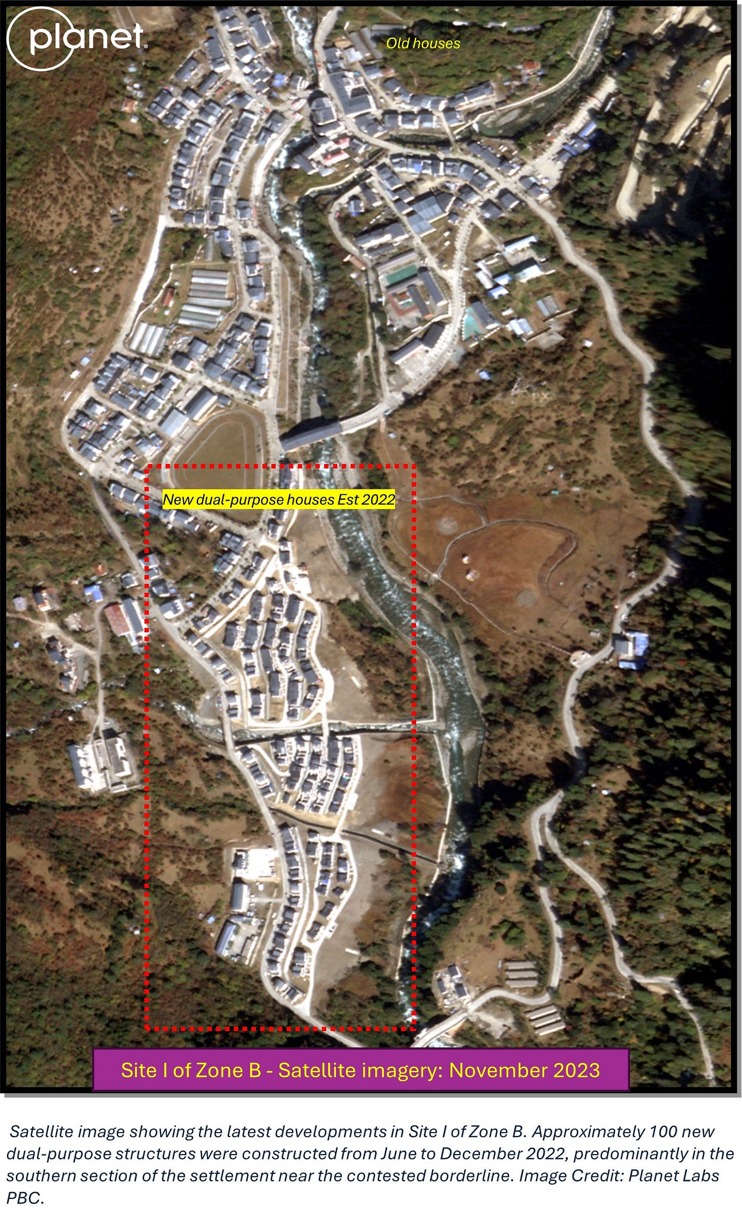
It is pertinent to observe that while the demarcation line extends east to west, Site I is situated north of this boundary. Conversely, Sites II and III are positioned to the south of the aforementioned line. Notably, this boundary, a subject of contention, bifurcates Site I from the other two sites.
2.2.1 Site I of Zone B: Migyutan
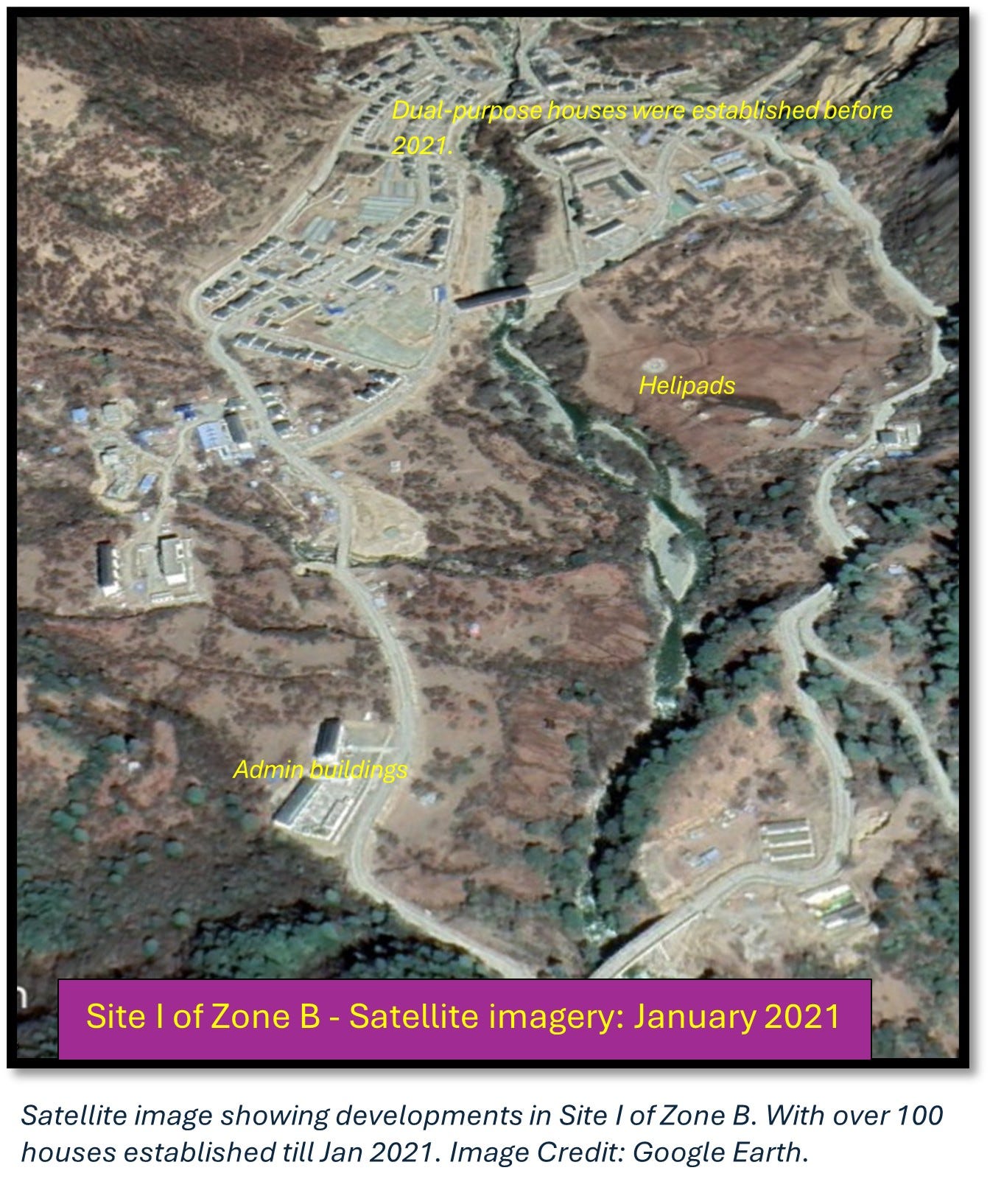
Site I Migyutan (Mi-Chi Tun) was a small village near the India-China border in the year 2000, just about 500 meters away. However, in 2013, construction began, and soon after, many buildings started to appear, increasing in number after 2018. Upon analysing satellite images taken over time, it is evident that the small village has transformed into a massive border settlement, with around 200 permanent houses and other supporting infrastructure. These houses appear to serve dual purposes and have infrastructure such as helipads, communication towers, solar panels, and other tall structures with boundary walls that could potentially be of military significance.
2.2.2 Site II of Zone B: Longju
The border settlements are not limited to the Migyutun alone. Roughly 500 meters south of the disputed boundary line, a parcel of land now referred to as Longju (identified as Site II in this analysis) was established on the riverbank through land claims. Although activities on this riverbank were noticeable as early as 2013, construction efforts commenced between July and August 2019, with the first potential military facility appearing to reach completion by February 2021. Now, it contains four blocks of multistory buildings with a storage facility. In addition, recent satellite images reveal a second military complex constructed between July and August 2023 featuring blue tent roofs, potentially designated for storage purposes.
2.2.3 Site III of Zone B: Louwa
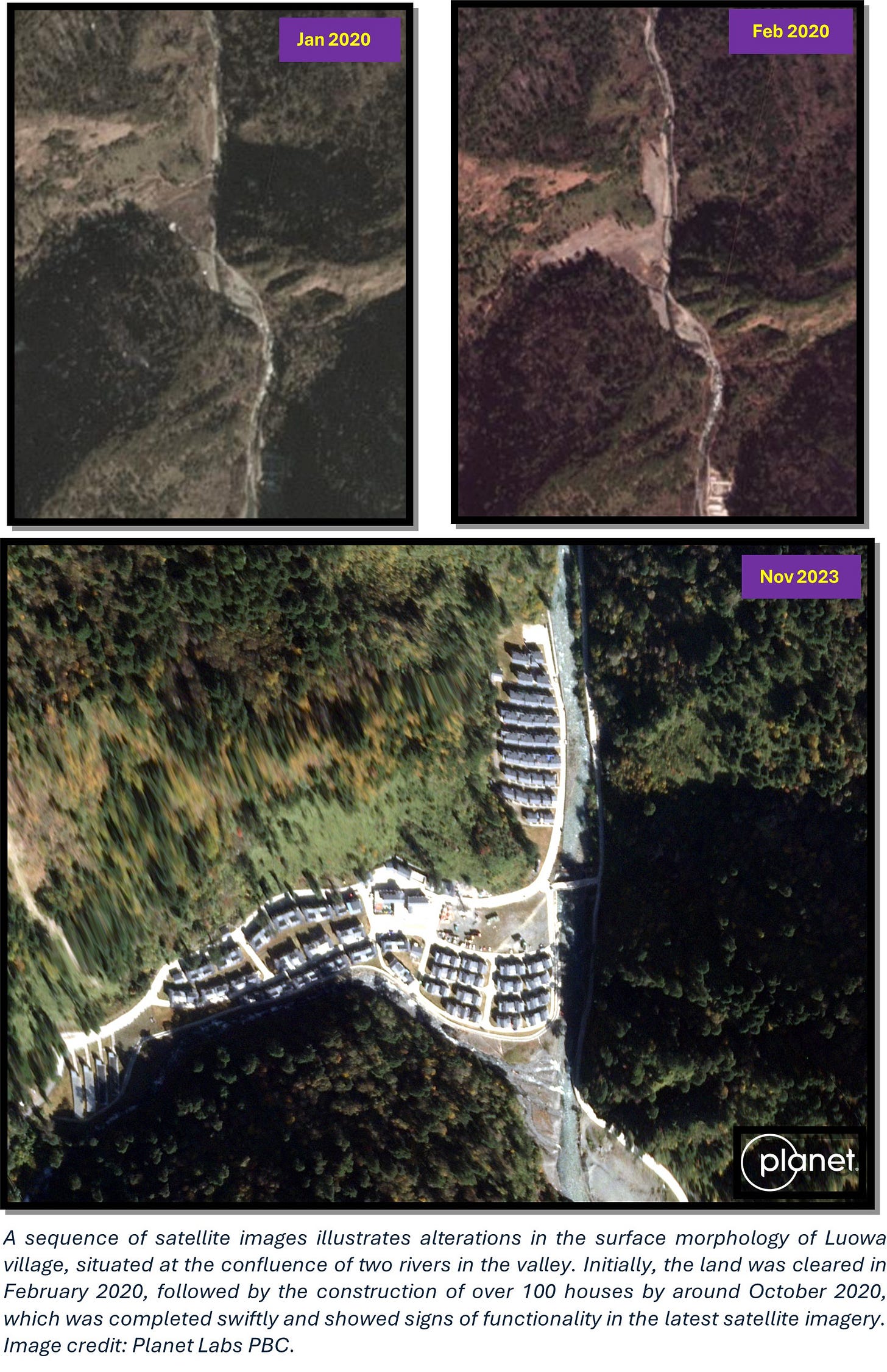
Heading southward along the valley in 2020, a group of houses emerged at the convergence of Rivers Tsari and Mipa, approximately 5.1 km from the border delineated by SOI. This settlement swiftly took shape between March and October 2020. The structures seem to serve dual purposes and are now seemingly fully operational, as evidenced by the vehicles parked in the communal area.
The advancements persist beyond that point, stretching another 2.5 km. Infrastructure such as a military road is being constructed alongside a military barrack spanning 0.02 sq. km and featuring three multistorey blocks around 750 m from Louwa village. Additionally, small structures are seen all along the valley. Recent satellite imagery shows the presence extends approximately 8 km southward from the disputed borderline.
3. Parting shot
In summary, by superimposing satellite imagery from various timescales onto the vector boundary of Arunachal Pradesh, as delineated by the Survey of India, it becomes clear that the locales known as Zones A and B are located in disputed territories. Zone B represents an enlargement of pre-existing settlements; however, Zone A is of new concern, given that it involves the establishment of fresh settlements on a mountain slope near the tribal villages.
A recurring trend noted is that the development of these settlements predominantly takes place during the pre-monsoon and monsoon seasons. Constructing roads adjacent to the river and land clearing in tactical areas indicate potential border settlements. Our continuing research has identified a number of significant and smaller settlements featuring dual-purpose housing in Tibet, especially within a 100 km radius of the Indian border. We are keen to share our insights in upcoming publications. Do keep an eye out for further updates!
The author thanks Lt Gen [Dr] Prakash Menon, PVSM, AVSM, and VSM [Retd] for giving constant support and motivation, as well as the reviewers.
Disclaimer: Please be aware that the information and opinions provided in this newsletter are intended for informational purposes only. We advise readers to exercise their own judgment and consider multiple sources of information before drawing any conclusions or making decisions based on the content presented in this newsletter.






Nice article with data and presented in a simple manner. The author's contributions, I presume would be highly beneficial to the Indian Security Agencies.
Nice piece with detailed study and analysis. Wonder what is our response???