
#13 Mapping the Rise of Solar Energy Harvesting in Tibet Autonomous Region

TL; DR
With solar farms utilising high irradiation and elevation, the Tibet Autonomous Region (TAR) is emerging as a significant hub for renewable energy. These advances are likely to help China achieve its 2060 carbon neutrality target.
The purposeful dual-use strategy, highlighted by the proximity of several solar projects near military installations, helps match the growth of clean energy with national security needs.
The use of technologies, such as bifacial panels, artificial intelligence monitoring, grid-integrated storage, thermal energy storage reservoirs, and portable batteries, is helping to efficiently and sustainably harness solar energy.
1. Introduction
The Tibet Autonomous Region (TAR), situated on the vast Qinghai-Tibet Plateau—often called the “Roof of the World”—stands out for its extreme elevation and striking geography. Averaging over 4,500 metres above sea level, Tibet features everything from towering mountains and deep river gorges in the southeast to expansive high-altitude plains in the northwest. This dramatic terrain is accompanied by unique climatic and hydrological systems, shaping the region’s renewable energy potential in distinct ways. China is systematically harnessing the region's renewable energy potential for both civilian and military purposes, with the overarching objective of achieving carbon neutrality by 2060.
The climate in TAR is heavily influenced by its altitude and location. While the northwest region remains cold and arid, receiving less than 100 mm of rainfall annually, the southeast benefits from monsoonal rains. Notably, higher elevations are warming faster than lower ones—an elevation-dependent warming (EDW) phenomenon that accelerates glacial melt and alters water cycles (Xiaodong Liu, 2017). These environmental dynamics directly impact the types and reliability of renewable energy sources in the region.
One of Tibet’s greatest renewable assets is solar energy. The region receives solar radiation ranging between 5,852 and 8,400 MJ/m² per year, placing western Tibet in the top-tier (Class I) solar resource category and the southeast in Class II. Interestingly, Tibet ranks among the sunniest regions globally, with more than 3,000 hours of annual sunshine across many western areas and an average of 8,160 MJ/m² annually in Lhasa alone. This has enabled the development of large-scale photovoltaic (PV) infrastructure, such as the 1.1 GW Yangbajing solar farm, building on long-standing traditions of passive solar design in Tibetan architecture. Still, challenges remain, particularly the seasonal drop in solar efficiency during winter and the damage caused by high levels of UV radiation. These factors highlight a paradox: immense renewable potential coexists with ecological sensitivity and infrastructure limitations.
When it comes to hydropower, Tibet’s hydropower potential is equally significant. The region is the origin of several of Asia’s major rivers, including the Brahmaputra, Indus, and Mekong. The Yarlung Zangbo alone has a 2,000-metre vertical drop in its lower reaches, making it a prime candidate for mega hydro dam projects. China has proposed generating up to 300 billion kWh annually here, triple the output of the Three Gorges Dam (Nithiyanandam, 2025). Nearly half of TAR’s water resources are now being regulated, reflecting two decades of hydropower investment. However, the reliability of this energy source is under pressure from EDW-driven glacier retreat and permafrost thaw, both of which disrupt consistent river flow and threaten long-term water security.
While solar and hydro dominate the renewable landscape, wind and geothermal energy also play a role, albeit a limited one. Wind energy, though logistically challenging to harness in this rugged terrain, has an estimated potential of 1.02 billion kW at 100 metres—about 26% of China’s total capacity. Geothermal energy, centred in the Yangbajing Basin, contributes on a smaller scale. The Yangbajing plant produces 25 MW—enough for 50,000 households—but wider adoption is hindered by high exploration costs and localised reserves. Meanwhile, traditional biomass—mainly yak dung and crop residues—continues to be used in rural areas. While essential for local livelihoods, it also exacerbates deforestation and indoor air pollution.
China’s sustained investments in TAR’s renewable energy sector reflect its commitment to achieving its net neutrality goal and its intention to drive economic development in one of its most remote regions. This energy push has added strategic depth to the region’s importance, especially given its proximity to India.
Considering these developments, a spatially detailed mapping of renewable resources—solar, wind, and hydro—is essential. Such mapping is crucial for understanding Tibet’s energy landscape and examining dual-use infrastructure, where energy assets may serve both civilian and military purposes. Strategic planning and policy must be informed by robust spatial analysis and satellite imagery to strike a balance between development and ecological, as well as geopolitical, considerations.
Therefore, our research aims to identify and map several key renewable energy centres around TAR, providing geostrategic assessments, spatial interpretations, and visual data insights. In this initial part, the primary energy source of TAR, namely solar energy farms and plants, and their spatial distribution and potential relationship with infrastructure are examined from a geospatial perspective.
2. Estimating the solar energy potential of TAR using remote sensing
One key factor to consider when selecting a suitable location for solar energy is the amount of sunlight the area receives throughout the year. Traditionally, this is measured using specialised instruments, such as pyranometers and pyrheliometers, which track both direct and scattered sunlight. Since measuring solar potential using ground-based instruments can be time-consuming and challenging to conduct in remote areas, satellite-based observations provide a practical alternative. They enable us to estimate solar energy potential from space, across various locations and periods, without the need to be on the ground.
However, it is essential to note that remote sensing measurements are generally less accurate due to their larger spatial coverage (lower spatial resolution) compared to ground-based instruments, which provide precise solar irradiance data at specific points. While ground-based tools cover only small areas, satellite-based observations can capture solar potential across much larger regions. Although remote sensing has certain biases and limitations, it is highly suitable for identifying suitable zones for large-scale solar farms, rather than for small-scale applications like rooftop solar. Additionally, remote estimation is significantly more cost-effective than traditional ground-based methods, making it a more attractive option for regional planning and development.

The remote sensing estimate shows that the overall solar irradiance over TAR was relatively high during April, May, and June. For 2024, the average irradiance recorded in Tibet exceeded 6.0 kWh/m²/day in April and May, with slightly lower values in June. After August, the irradiance steeply declines to about 3 kWh/m²/day during December and January. While Figure 1 represents the average estimate for the entire TAR, the actual forecasts for specific locations vary based on each zone's climatic conditions and topographical characteristics.
In this research, we conduct solar irradiance calculations based on remote sensing using the hourly climate reanalysis data provided by the European Centre for Medium-Range Weather Forecasts (ECMWF). The final product consists of terrain-corrected and aspect-corrected estimations. This means that in mountainous areas, such as the TAR, the actual solar radiation received on the ground is influenced not only by atmospheric conditions but also by the terrain's slope. Steeper slopes receive less radiation depending on the sun's angle. Additionally, the aspect, which refers to the direction the slope faces, affects the amount of radiation received; south-facing slopes in the Northern Hemisphere generally receive more sunlight. These corrections were applied to obtain a more accurate estimation of the solar potential in the region.
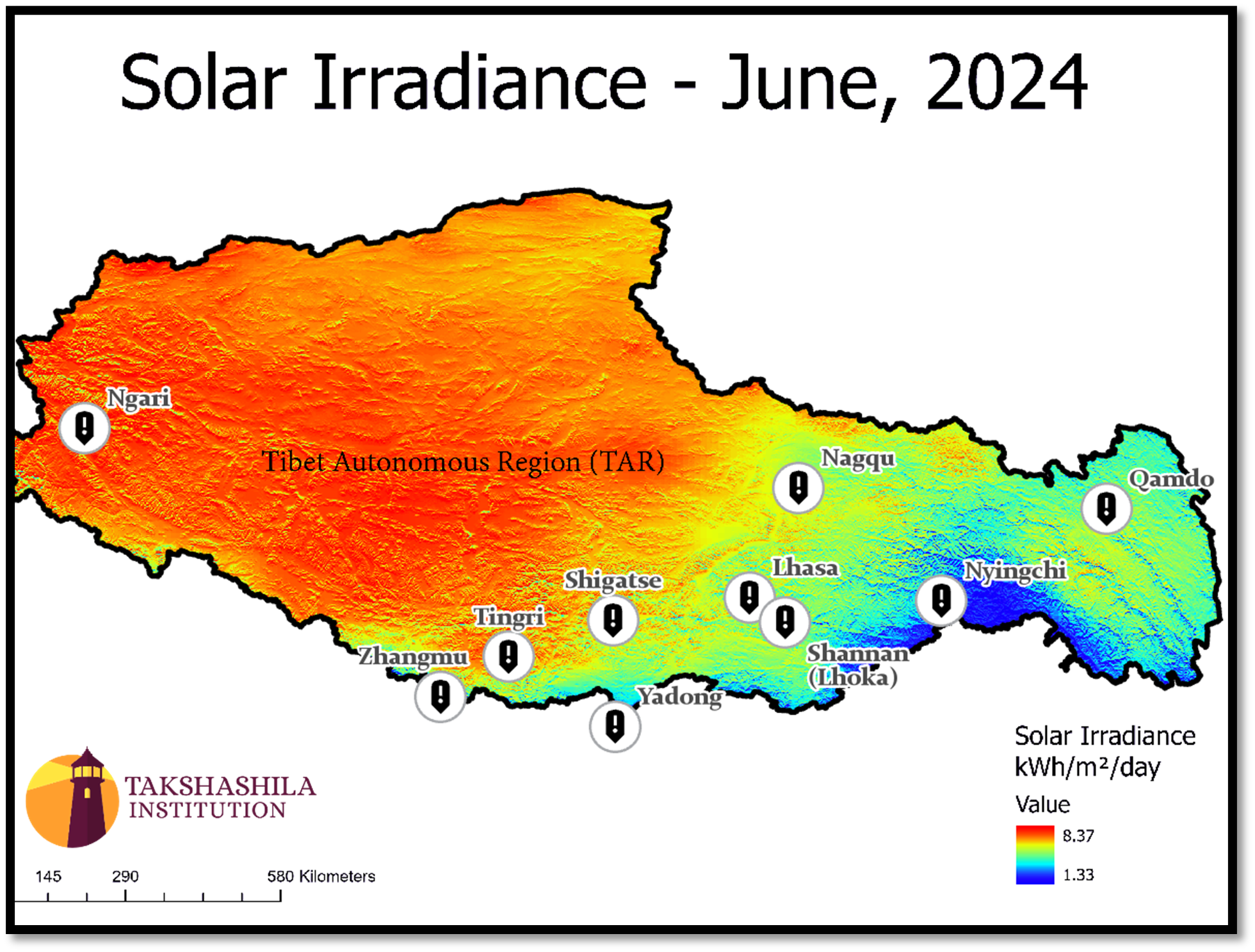
Figure 2 indicates that western, northwestern, and southwestern Tibet receive a lot of sunlight, while the central and northeastern areas receive a moderate amount. The southeastern part, closer to India’s Arunachal Pradesh, gets the least. These differences are likely due to the region's diverse range of climates. Most parts of Tibet receive sufficient sunlight to support large-scale solar farms, off-grid setups, and solar-battery systems. Tibet is among the sunniest places on Earth, comparable to the Atacama and Sahara deserts. Its high altitude, low pollution, and mostly clear skies make it an excellent place for harvesting solar energy.

Figure 3 shows how solar irradiance levels vary across Tibet during winter. The central and southern regions continue to receive high irradiance, while the northern and northwestern parts see a noticeable drop. The southeastern area, near India’s Arunachal Pradesh, still gets the lowest levels. Interestingly, the central and southern parts stay relatively consistent in their irradiance throughout the year. These regions are well-suited for capturing solar energy thanks to their altitude, terrain, and climate. That is why most mid-sized solar projects are located here, although a few large ones have been established in northeastern and northwestern areas with high irradiance and suitable land.
Further details about solar energy projects in TAR, from known sources and new ones identified in this study, will be discussed in the next section. As we examine the distribution of different types of solar plants, it is essential to highlight the role of geospatial technology in this context. These tools help map existing solar sites and identify the most suitable new locations by combining various layers of information, including irradiance levels, land use, nearby infrastructure, settlements, military zones, and power grid access. Finding the right spot in the TAR, where land is ample, is not just about high irradiance. It also means choosing a location near roads, power lines, and future developments to make solar energy systems more efficient and practical.
3. Different scales of solar projects
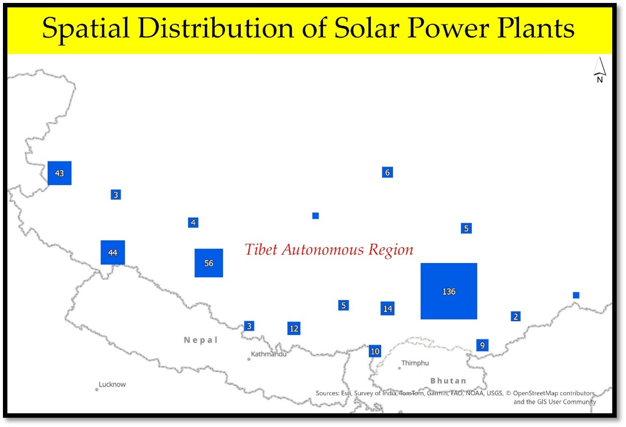
To understand the different scales of solar projects currently operating and proposed in TAR, we have translated the available datasets from Global Energy Monitor into two maps. One map displays small solar projects with a capacity of less than 20 MW, while the other shows solar projects with a capacity of 20 MW or more.

The list features a total of 27 solar projects, each boasting capacities that range from a modest 1 MW to an impressive 15.9 MW, all of which have been operational since 2010. Most of these plants utilise established Photovoltaic (PV) technology, although some projects are classified as assumed PV, indicating a reliance on similar solar principles.
Diving deeper into the capacity distribution, most projects (15) fall within the range of 5.9 MW to 10.3 MW, showcasing a significant concentration of mid-sized installations. In addition, six projects operate within the smaller capacity range of 1.5 MW to 5.9 MW, while another six projects exceed the 10.3 MW threshold, highlighting a diverse portfolio of solar energy initiatives.
Interestingly, around 88% of the projects developed between 2010 and 2017 exceeded 10 MW, indicating a trend toward larger-scale solar solutions during this period. Geographically speaking, most of these projects are in the southern and central regions of the TAR, where solar insolation remains consistently high throughout the year, optimising energy production and indicating a deliberate choice to harness the area's favourable climatic conditions for solar energy generation.
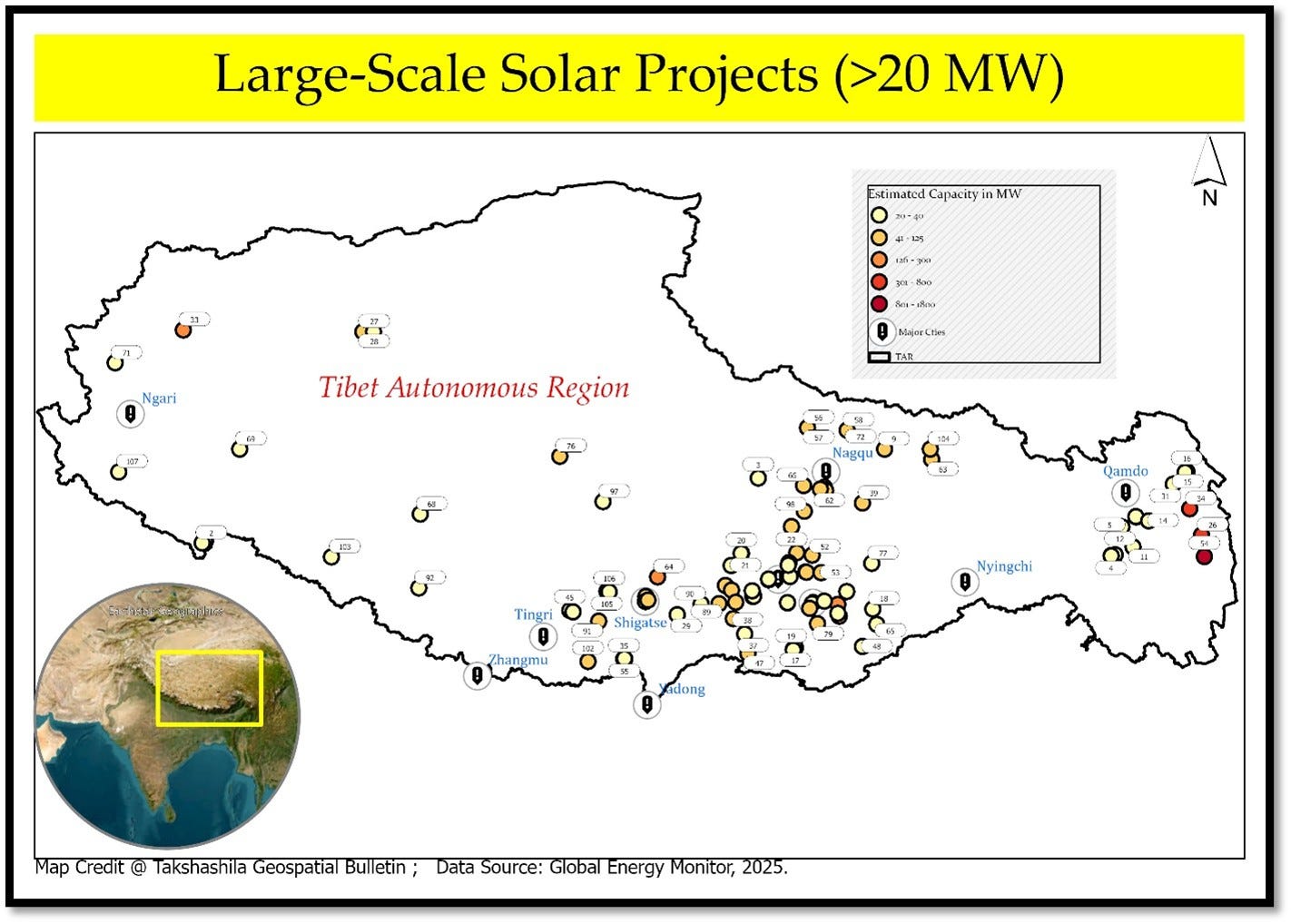
A total of 109 solar projects with a capacity of 20 MW or above have been identified in TAR. While most of them are photovoltaic, and very few are solar thermal technologies. The total installed capacity is 9365 MW, of which 74 are operational and 20 are under proposal. The highest number of projects is observed in Baingoin County in Nagqu Prefecture has the highest number of such projects. Baingoin County's prominence in renewable energy projects can be attributed to its favourable geographical conditions and the broader regional emphasis on expanding clean energy infrastructure. The county's initiatives significantly contribute to Tibet's overall renewable energy capacity.
Over the past 12 years, TAR has made significant advancements in its renewable energy development, particularly for projects with capacities of 20 MW or greater. On average, the region has installed approximately 460 MW of renewable energy capacity annually, although this figure has shown considerable variability. The lowest recorded annual installation was 20 MW, while the highest soared to an impressive 2,675 MW, illustrating the fluctuations in development activity. Notably, years in which installations exceeded 485 MW were classified as high-activity years, marking crucial periods of growth and investment in renewable energy infrastructure. In 2023, Tibet made a substantial leap forward, adding 700 MW through the initiation of 11 projects, which underscored its ongoing commitment to scaling up renewable energy capacity. The momentum continued into 2024, with an additional 860 MW installed across 15 projects, demonstrating a sustained commitment to clean energy initiatives. However, 2025 marked a pivotal year in Tibet’s renewable energy trajectory, as the region witnessed an extraordinary escalation, contributing 2,600 MW from only two large-scale projects. This dramatic increase not only reflects TAR's commitment to expanding its clean energy resources but also underscores the region's potential to become a significant player in the renewable energy landscape.
In terms of spatial distribution within the region of TAR, a significant concentration of moderately sized plants can be found predominantly in the central and southern areas. Conversely, the mega projects, which often involve substantial investment and infrastructure, are more dispersed across the eastern and western regions. A few of these large-scale initiatives can also be observed in the central and southern parts, although they are less prevalent there. This distribution reflects a planned approach to resource allocation and development, as well as the varying economic focuses of different areas within TAR.
When it comes to ownership of the solar plants, most are state-owned enterprises, either at the central or provincial levels. Overall, these developments demonstrate Tibet's strategic emphasis on developing its renewable energy infrastructure, aligning with global trends toward sustainability and reducing reliance on fossil fuels.
4. More solar projects revealed
Our research, based on open-source information and image processing of remotely sensed data, reveals a significant number of solar projects across different regions in TAR, serving diverse purposes. This study aims to explore and analyse some of these key projects, highlighting their various objectives and functions within the area.
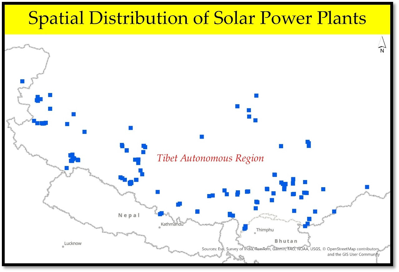
Figure 6 displays a comprehensive overview of over 200 solar plants and farms of varying scales identified in the TAR analysis. This collection encompasses a diverse range of small-scale solar installations (excluding solar rooftops), which are primarily designed to provide energy for small industries, residential housing colonies, and military bases. In these settings, solar energy serves dual purposes: it not only generates electricity but also provides heating solutions for various applications.
In contrast, the larger solar farms are engineered for extensive electricity generation, aiming to supply power to local communities and remote areas. These facilities are equipped to harness significant amounts of solar energy, which is then integrated into the electricity grid, facilitating broader distribution to meet the energy demands of a more extensive network. This dual approach highlights the versatility of solar energy in addressing both localised needs and contributing to the overall energy infrastructure.
Among the various clusters analysed, Lhasa stands out with over 100 documented observations, making it a significant area of interest. Often referred to as the "Sunshine City," Lhasa boasts an impressive annual average sunshine duration of about 3,000 hours. This remarkable sunlight exposure translates to some of the highest total solar radiation values in China, reaching around 8,160 megajoules per square meter (MJ/m²) per year.
The Lhasa Lhunzhub solar farm is currently in the pre-construction stage and is one of the significant projects in Lhasa. The Damxung County project is one of the major hybrid solar projects in Tibet. The Jiawa Phase I solar-plus-storage plant, situated at an elevation of 4,500 meters, showcases the region's capacity to develop and operate state-of-the-art solar infrastructure. These systems support Tibet's local energy needs and broader renewable energy initiatives, showcasing a workable strategy for harnessing clean energy in urban environments through the combination of Lhasa's abundant sunlight and advanced solar technology.
4.1 Closer look at key solar projects in TAR
4.1.1 Shigatse

The area around Shigatse Peace Airport has become a significant hub for tapping into solar energy. Back in February 2020, there were no noticeable solar farms near the airport. However, satellite images from subsequent years show rapid development in this area. The first planned solar farm, located southwest of the airport, appeared in 2020. In the following year, another installation emerged, visible in images from January 2024, this time located on the southeast side. The most recent development, captured in January 2025 images, shows a fully operational solar farm adjacent to the southeast area. This one appears to be the largest among the three. The sizes of these three solar farms are approximately 1 square kilometre, 0.6 square kilometres, and 1.145 square kilometres, reflecting steady growth over time.
Shigatse Peace Airport, established initially as a military base in 1973, was expanded for dual military and civilian use in October 2010. It now hosts one of the longest runways in Tibet. With increasing energy needs in the region, particularly near key infrastructure such as the newly established and operational railway station, the power demand continues to rise. Solar energy development in the area shows no signs of slowing down.
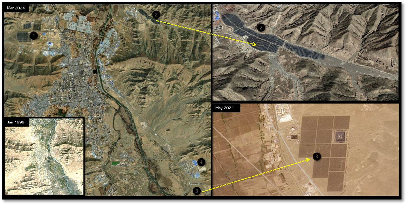
Before 2000, Shigatse had not witnessed this much development. Today, it has grown into a prominent city in the Tibet Autonomous Region. In this area, three major solar farms have been identified. The first set of solar farms lies to the west of the city, marked as 1 in Figure 9. This installation was initially established in 2011 and was later expanded. It now covers three adjacent plots of solar farms, measuring approximately 0.16, 0.17, and 0.54 square kilometres.
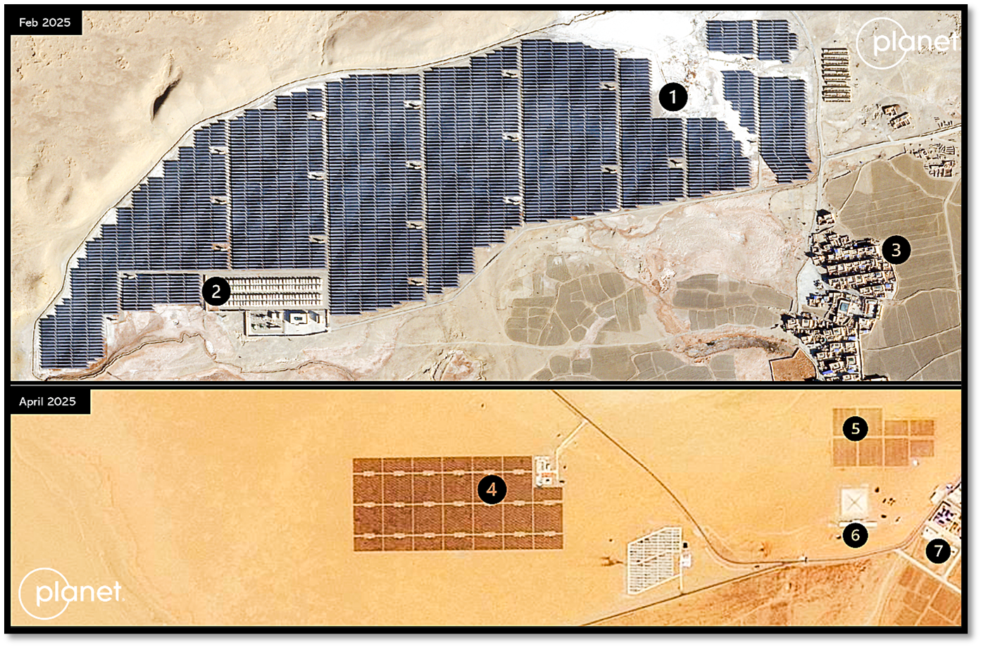
Imagery from 2018 shows another solar farm located in a valley to the east of the city. This valley installation spans about 0.5 square kilometres. Interestingly, although additional land was cleared in the valley for future expansion, the project appears to have halted before the new areas were fully developed with solar panels. Temporal imagery suggests that the valley installation is often snow-covered in winter; however, newer technologies may be deployed to mitigate the impact of snow accumulation.
The most recent addition is a new solar farm located near Highway G318. Covering around 0.4 square kilometres, its construction began in October 2024 and witnessed significant development by 2025. This site is situated adjacent to a developing industrial area. This farm features a massive, black, elevated structure, possibly a cutting-edge thermal energy storage pit measuring 100 meters by 100 meters, which helps overcome seasonal limitations. Placed on the southeast corner of the site
In terms of technology, these advanced solar farms use a mix of fixed-tilt and tracking solar modules. Some are integrated with energy storage systems (ESS), while others—like the third plant mentioned above—are directly connected to nearby substations. Evaporation ponds or wastewater holding pits are often included in the site layout for maintenance purposes.
4.1.2 Gar County

The solar photovoltaic farm located in Ghar County is a relatively new installation, situated at an elevation of 4,300 metres and located approximately 65 kilometres from Demchok. With a capacity of 30 megawatts, this plant has become operational relatively recently. What makes this site particularly interesting is its proximity to military infrastructure. The solar facility comprises a main plant and several smaller ancillary units, collectively covering an area of approximately 2 square kilometres. The entire setup is positioned right next to the G219 highway.
Situated just three kilometres uphill from the solar site is a military Circularly Disposed Antenna Array (CDAA), which serves as a sophisticated listening post. This installation is believed to have been established around a decade ago and plays a vital role in intelligence-gathering operations. The CDAA is composed of two distinct sets of 11 antennas, strategically arranged in circular formations. One set is positioned 50 meters from the centre of the array, while the other is located at a distance of 100 meters, enhancing its surveillance capabilities.
The proximity of the CDAA to both the solar farm and nearby hydrocarbon extraction infrastructure strongly indicates that the area is being developed as a crucial energy supply hub. This dual functionality could support not only military operations but also broader infrastructure development in the region, highlighting the strategic importance of the location.
Another noteworthy aspect is the remarkable speed of construction for the solar farm. Land clearing for the solar panels commenced in September 2022, and within just a month, the support structures and arrays were installed. By November of the same year, the solar panels were fully operational. This rapid timeline—from initial land clearance to full functionality—took less than three months. Such efficiency is awe-inspiring given the challenging altitude and remoteness of the site, which typically involves logistical hurdles and longer construction durations. This efficiency may signal a well-coordinated effort to rapidly enhance energy capabilities in the region.
Since summer 2025, an ancillary facility has been under construction adjacent to the regular grid and storage facilities of the solar plant. The new facility features two large tanks that could potentially be used for storing salt for thermal energy or as part of a hydrogen production system. While there is no official confirmation, it is likely intended to enhance the plant’s storage capacity or support additional energy functions.
The electricity generated is most likely transmitted to nearby facilities via high-voltage lines, which are seen crossing the area. The region is also home to hydropower production sites and hydrocarbon operations, underscoring its role as a key hub for renewable and mixed energy sources. Although not far from the international boundary, the strategic use of solar energy for military support activities in this region appears highly possible.
4.1.3 Jomda Dzong

The two solar projects in Jomda exemplify the ongoing development of large-scale infrastructure in the sparsely populated and remote regions of the Tibet Autonomous Region. Located in eastern Tibet, where the elevation is relatively lower compared to the western regions, these projects cover a total area of approximately 1.5 square kilometres and 1.2 square kilometres, respectively. Both installations are strategically located along Highway G557. Despite the sparse surrounding population, these solar projects are designed not only to generate electricity for the region but also to facilitate broader developmental initiatives. A key objective of these projects is to supply energy for both ongoing and future infrastructure endeavours, including a significant expressway connecting Chengdu and Chamdo. These power projects, which have been operational for at least five years, play a crucial role in enhancing the region's energy capacity.
4.1.4 Kamba County
The two solar farms in Kamba County are located approximately 35 kilometres north of Sikkim. Covering areas of around 0.55 and 0.35 square kilometres respectively, these farms are situated at elevations of roughly 4,500 and 4,600 metres. The first solar farm was built in the second half of 2020, while the second was constructed a year earlier. Both are now fully functional and help supply power to the surrounding border areas.
Interestingly, the first solar farm is built over a stream that feeds into the Yarlung Tsangpo River. This site hosts one of the largest solar installations in the region, with an estimated capacity of approximately 30 megawatts, and features dedicated storage facilities, likely utilising lithium-ion batteries.
The lower portion of Figure 12 shows several smaller solar farms set along a mountain slope, located next to dual-purpose settlements. These installations serve as key sources of energy for the local area. Notably, both solar farms are connected by the S-208 highway and lie adjacent to National Highway G-219. Their proximity to the Line of Actual Control also gives the area strategic importance, demonstrating how solar energy can support both civilian and military infrastructure in high-altitude regions.
4.1.5 YangbaJain

YangbaJain is a significant location for the PLA, not just for its strategic importance but also as a substantial hub for geothermal energy production and scientific research. Its unique geothermal features make it ideal for satellite data calibration and related experiments. Located in central Tibet, the area hosts two distinct clusters of solar farms. Among these, the solar farms marked as 3 and 4 are some of the oldest solar farm installations in the region. Unlike newer systems equipped with advanced storage, these older farms were connected directly to the grid. In contrast, the site marked as 1, currently under construction, is set to become one of the largest solar panel arrays in the area. It is located on a mountain slope on the banks of the Duilong River, adjacent to Highway G109.
The area marked as 2 identifies a long-standing, highly secure military complex that remains critical to Chinese military operations. In terms of elevation, the first zone sits at approximately 4,417 metres, while the second cluster (sites 3 and 4) is around 4,300 metres. Locations marked 5 and 6 correspond to the Qinghai–Tibet highway and the Qinghai–Tibet railway line, with 6 also indicating the railway station. Overall, the site reflects how renewable energy is being harnessed to support self-reliance and sustain critical infrastructure in the region.
4.1.6 Mahang
Mahang, located north of Lhasa, is home to two solar farms—one covering about 0.5 sq. km and the other spread across a cluster of approximately 0.45 sq. km. The area marked 1 in the image refers to a relatively new solar farm, where land clearing began in September 2023 and construction appeared to be completed by the end of that year. This farm is situated along a tributary connected to the main river and is located in a valley, which could potentially impact water flow and related activities. Notably, in December, the site experienced snow cover that blanketed the solar panels, potentially affecting energy generation. To support uninterrupted supply during such conditions, a battery storage unit was also identified at the site.
About 4 km south of this newer installation lies an older solar farm, established over a decade ago. This older facility consists of two sections connected by a narrow stretch and operates with standard photovoltaic setups. Both solar farms appear to be meeting the energy needs of the local rural community. They are likely part of broader efforts to promote regional development, something that is becoming increasingly evident in the surrounding infrastructure. Interestingly, a small runoff from the river hydro dam is located just above the solar farms, which could also be harnessed where feasible. Altogether, Mahang represents a compelling example of how remote areas can harness solar energy to meet local needs and foster sustainable growth.
4.1.7 Pangong

This site is a clear example of how small-sized solar photovoltaic panels are used to generate energy in remote areas that need a self-sustaining power source. In this case, small solar panel arrays have been installed within a fenced compound to meet local energy needs, likely to support equipment or personnel stationed on the nearby mountain slope. The area is located within a highly strategic and militarised zone. In the image, Number 1 marks the radar site along with a 3D view of the area; Number 2 shows a close-up 2D view of the radar and the solar panels; Number 3 is marked over Pangong Tso lake; and Number 4 highlights surrounding military developments. Similar setups with compact solar panels are found in other remote locations where traditional power lines are difficult to install, or where off-grid energy is essential for strategic operations. These systems are primarily used to provide electricity and heating in such remote areas.
4.1.8 Chusum

Chusum hosts two large solar farms and a smaller solar grid network, as evident from satellite imagery. One of the major solar plants is located in the Chusum valley and has been operational for over five years, covering an area of approximately 0.67 square kilometres.
More notably, a newer solar plant was established on top of a mountain in 2024. Early signs of construction appear in March 2024 satellite imagery, with solar panel installation becoming visible in April. The plant seems to have been completed by August 2024 and likely became operational shortly thereafter. Its location, at a high elevation with year-round sunlight, makes it ideal for efficient energy harvesting and a wide range of applications.
Another point of interest is a small solar panel setup within the Chusum valley itself. Installed in November 2024 and completed by January 2025, this unit is relatively small but notable for its proximity to a camouflaged foil-covered structure. This structure resembles similar installations observed elsewhere and may represent a prototype or emerging form of energy storage technology being tested by China.
In the image, markers 1 and 2 indicate the location of the latest, larger solar farm atop the mountain. Markers 3 and 4 refer to the sites within the valley, covering both the older and newly established plants. Marker 5 is placed next to the small object, which may be a new energy storage technology.
4.1.9 Yadui

The Yadui area is home to two massive high-tech solar power plants under the Huadian Xizang Caipeng Solar Project, which has been developed in two phases. Phase one was completed by the end of 2023 and began production in December 2023 with an expected capacity of 50 megawatts, covering an area of approximately 0.55 square kilometres.
Phase two started operations a year later, in December 2024. It is twice the size and capacity of the first phase, generating 100 megawatts of power. What makes these plants remarkable is not just their scale, but the fact that they are the highest-altitude photovoltaic projects in the world. They demonstrate the ability to generate clean energy effectively even in extremely high-altitude environments. The second phase alone is designed to generate about 155 million kilowatt-hours annually—enough to power roughly 50,000 homes. This contribution significantly supports the region’s solar energy needs and helps reduce carbon dioxide emissions by approximately 101,800 tonnes per year, according to available sources. These plants are equipped with state-of-the-art technology. The second phase features a 7.5% higher conversion efficiency compared to the first. The bifacial solar panels used in this phase increase efficiency by 20% over traditional models and are built to withstand extreme wind and snow conditions.
Overall, this project stands as a powerful example of clean energy innovation at high altitude—an actual “top-of-the-world” demonstration of technological capability and the pressing need for sustainable energy solutions.
5. Spatial relationship between military areas and solar plants
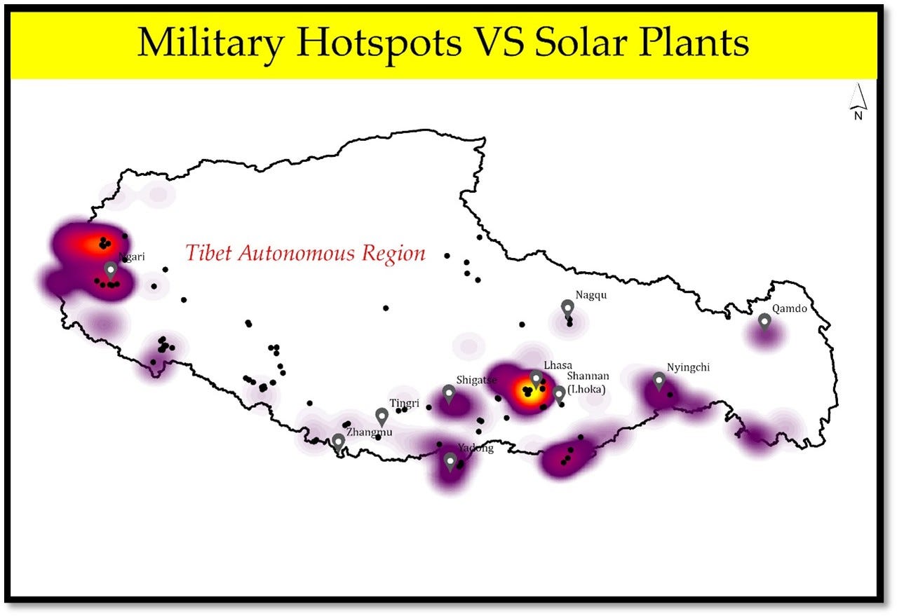
The overlaid map of solar power plants and military hotspots in the Tibet Autonomous Region suggests a notable trend—military areas with limited access to other energy sources appear to rely more heavily on solar power. In such locations, solar energy has become a key supporting source for military operations. What stands out is how these solar power plants are designed not just to generate electricity, but also to store and distribute it efficiently. They help balance seasonal energy needs and offer resilience against climate variations, thanks to advanced storage and energy-sharing technologies. On the map, areas with the highest concentration of military establishments are shown in yellow, moderate concentrations in red, and the sparsest areas in pink. While solar plants are spread across the region, their placement does not necessarily correspond to the density of military sites, suggesting a more strategic or selective deployment rather than a one-to-one distribution.
6. Parting shot
This study examines the rapid expansion of solar energy in Tibet, starting with an assessment of the region's significant solar potential and its seasonal characteristics. The optimal period for harnessing solar power varies spatially. This analysis provides a valuable foundation for understanding how renewable energy is being utilised on a large scale in one of the world's most challenging high-altitude environments.
Through the mapping and interpretation of multiple solar energy datasets, the spatial distribution of solar installations across the Tibetan Plateau has been visualised. A prominent trend emerging from this analysis is the shift toward large-scale solar projects, typically exceeding 20 megawatts, which are predominantly located in the western and northern regions of the country. In contrast, smaller, earlier-generation plants remain clustered in central Tibet, indicating an evolving spatial and temporal pattern likely shaped by factors such as land availability, elevation, and solar abundance.
The spatial analysis conducted has effectively mapped concentrations of solar facilities. While the plant count may be slightly inflated due to automated classification methods that sometimes register fragmented arrays as distinct units, the analysis offers a robust and timely representation of Tibet’s solar landscape. Importantly, the study has also brought several previously undocumented installations to light, contributing fresh insights to our understanding of renewable developments in the region.
A closer look at individual projects reveals a wide-ranging portfolio—from vast solar farms to modest but locally significant units, some of which are fully subsidised. The developments surrounding Shigatse, particularly near airport infrastructure and urban edges, demonstrate clear technological progression. In Gar County, the proximity of solar plants to military facilities suggests an emerging energy-security nexus, with solar power supporting off-grid operations through battery-backed systems.
Elsewhere, installations such as those in Chomda–Doshong follow the contours of mountainous terrain, while Kamba County exemplifies the move towards mega-scale expansion. The presence of solar arrays near Pangong Tso, potentially linked to radar infrastructure, highlights the strategic utility of renewable energy in sensitive border areas.
Remarkably, even in extremely high-altitude environments such as Chusum and Yadui, solar installations have been sited with precision, taking into account slope, solar exposure, and environmental constraints. These systems perform reliably despite harsh climatic conditions, a testament to years of adaptive engineering and technological refinement.
A defining feature of Tibet’s solar push is the deployment of advanced technologies. Bifacial photovoltaic modules—capable of capturing sunlight from both sides and increasing yield by up to 20%—have become standard in flagship projects like Huadian Caipeng and Jiawa Phase I. Large-scale battery storage systems, such as Jiawa’s 250 MW/200 MWh facility, are enabling a stable, round-the-clock energy supply. Hybrid projects, including Dangxiong’s solar thermal–PV combination, demonstrate the capacity to deliver dispatchable power and manage peak loads efficiently.
Across many sites, high-efficiency cells such as Passivated Emitter and Rear Cell (PERC), half-cut, and emerging perovskite variants are being adopted. AI-powered intelligent monitoring systems are now commonplace, supporting real-time optimisation and predictive maintenance. Structural designs are increasingly tailored to endure high UV exposure, strong winds, and heavy snowfall—once considered exceptions, these design features are fast becoming standard.
Another key trend is the rise of integrated clean energy bases, co-locating solar, hydro, and storage systems, as seen along the Jinsha and Yalong rivers. These hubs enhance regional energy security and support broader decarbonisation goals.
Connection strategies have also evolved. While earlier plants supplied power directly to the grid, newer systems often incorporate storage for greater flexibility across daily and seasonal cycles—and in some cases, mobility. Solar power is increasingly integrated with other renewables, such as wind and hydro, creating decentralised yet interconnected energy ecosystems. This reflects China’s broader strategic intent to maximise the use of renewable resources for national energy resilience.
Many installations are located far from established infrastructure, suggesting possible links to future development zones, critical assets, or military outposts. Construction timelines are notably short, with many projects completed within four months and rapidly integrated into regional or national power systems.
Though officially positioned within China’s 2060 carbon neutrality roadmap, the dual-use character of many installations is evident. Large-scale and tactical systems alike serve civilian demands while also meeting the logistical requirements of the People’s Liberation Army, revealing a deeper strategic calculus.
Ultimately, the expansion of solar energy in Tibet is more than a story of renewable transition—it is a case study in the convergence of energy, environment, and security at high altitudes. The pace, scale, and sophistication of these developments reflect a deliberate and multi-layered policy agenda.
Further investigations into other renewable sources and their synergy with solar power are currently underway. They will be featured in a forthcoming edition, offering more profound insights into the region’s evolving energy architecture.
The author thanks Lt Gen [Dr] Prakash Menon, PVSM, AVSM, VSM (Retd) and Air Marshal TD Joseph AVSM, VM, VSM (Retd) for giving constant mentorship, other colleagues, external experts and reviewers.
For regular updates on our geospatial research, stay tuned to https://takshashila.org.in/geospatial-research.
The author, Dr Y Nithiyanandam, tweets (X.com) @prof_nithiya
Disclaimer: Please be aware that the information and opinions provided in this newsletter are intended for informational purposes only. We advise readers to exercise their judgment and consider multiple sources of information before drawing any conclusions or making decisions based on the content presented in this newsletter.
Declaration: This article has been proofread using AI tools.
For more products from Takshashila Institution, refer to: https://takshashila.org.in/newsletters/