
#12 Medog Mega-Dam 2.0: Renewed Insights on Risks & Impact

TL; DR
The Medog dam’s undisclosed details and lack of data sharing poses serious risks to downstream water security and ecological stability.
The Yarlung Tsangpo basin is already experiencing stress, affecting both the quality and availability of water.
Given the region’s climate vulnerability and disaster risks, China should permanently reconsider and abandon the project.
1. Backstory
In March 2021, China’s 14th Five-Year Plan was approved, setting ambitious goals across multiple sectors, including developing a modern energy system. Among its key initiatives is creating a renewable energy hub in Nyingchi prefecture, integrating hydropower, wind, and solar energy projects. The centrepiece of this strategy is the construction of a colossal 60,000 MW hydropower plant on the Yarlung Tsangpo River (Brahmaputra), boasting a generation capacity three times greater than the Three Gorges Dam, currently the world’s largest operational hydropower facility. This project, if successful, could significantly contribute to the region's energy needs and reduce reliance on fossil fuels.
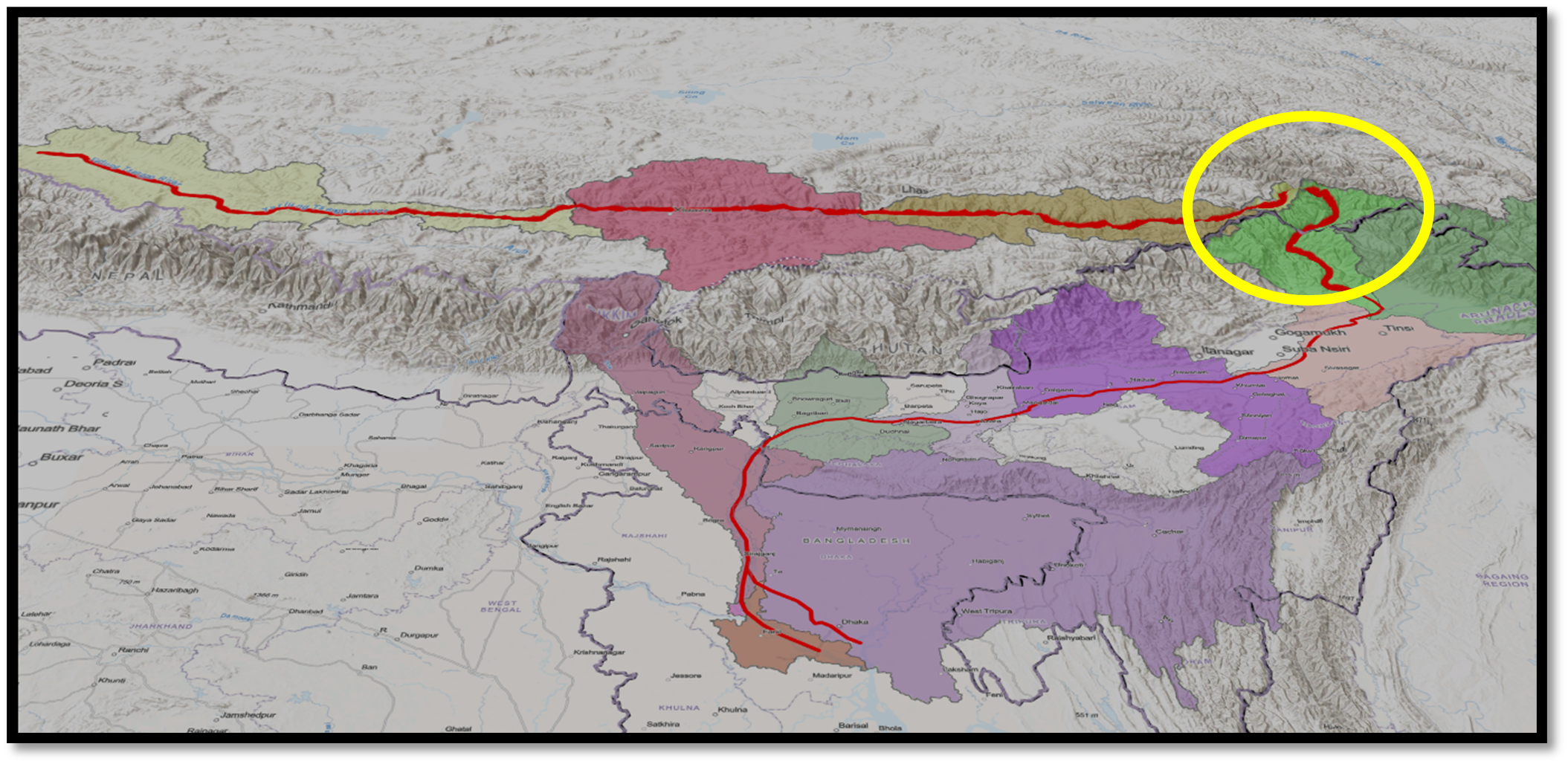
In December 2024, China’s state news agency Xinhua confirmed the government’s financial approval for this project, described as an engineering marvel of unprecedented scale in reports. The mega-dam is planned for the lower reaches of the Yarlung Tsangpo River, close to the Line of Actual Control (LAC) between China and India—a region fraught with strategic sensitivities. This proximity has intensified concerns over potential downstream impacts, including disruptions to water flow, sediment transport, and the risks of artificial floods, which could exacerbate tensions between the two nations.

The Yarlung Tsangpo, originating in the Angsi Glacier of the Tibetan Himalayas at 5,319 metres, is a unique and vital river. It flows through the Tibet Autonomous Region (TAR), carving one of the world’s deepest canyons at the 'Great U Bend' before descending into India as the Siang River and eventually transforming into the Brahmaputra in India and the Jamuna in Bangladesh. Stretching over 3,350 kilometres and spanning four nations—China, India, Bhutan, and Bangladesh—the river is vital to the region, nourishing the world’s largest delta, hosting remarkable biodiversity, and supporting millions of livelihoods.
The proposed hydropower plant near the Great Bend underscores China’s ambition to dominate large-scale renewable energy development. However, it also raises serious geopolitical and ecological concerns. The scale of the project, combined with the fragility of the Himalayan ecosystem, makes the potential for environmental disruptions significant. Furthermore, the lack of transparent data-sharing mechanisms with downstream nations has heightened fears over unilateral water resource management. This lack of transparency is a pressing issue that needs to be addressed to ensure the project's success and the region's stability.
While the project exemplifies China's commitment to renewable energy, its broader implications—spanning ecological, economic, and geopolitical dimensions—warrant rigorous scrutiny and regional dialogue. Without greater transparency and cooperative frameworks, this mega-dam could become a potential geopolitical flashpoint in a delicate regional equilibrium.
2. Medog Mega-Dam 2.0
The previous edition of the Takshashila Geospatial Bulletin offered a comprehensive analysis of the mega-dam project, delving into its background and key challenges and drawing parallels to China’s existing colossal “Three Gorges Dam.” It also provided a brief overview of climate change, disaster-related risks, and China’s strategic pursuit of renewable energy, shedding light on its underlying motivations and ambitions.
In contrast, this edition focuses on addressing critical gaps in the existing literature, taking a more detailed approach to understanding the potential impacts of China’s Mega dam project in the context of climate change, natural disasters, and evolving hydrometeorological patterns. It undertakes an in-depth examination of the Yarlung Tsang Po River basin, employing a geospatial lens to decode its dynamics and developments surrounding the basin in recent years. Additionally, this edition seeks to answer some pressing questions about downstream implications, aiming to provide a nuanced understanding of such projects' broader environmental, geopolitical, and socio-economic consequences. This expanded perspective builds upon the groundwork laid in the earlier edition and offers fresh insights into an increasingly critical issue.
3. The extended Brahmaputra River basin


Five critical watersheds influence the central Brahmaputra basin. The Tibet Autonomous Region's (TAR) Yarlung Tsangpo sub-basin is the longest and largest. Other major sub-basins fall into India, Bangladesh, and Bhutan. It should be noted that the amount of water that each sub-basin delivers to the main channels is primarily determined by the amount of precipitation that each watershed region receives. Therefore, the size of each sub-basin does not immediately reflect their actual contribution. In this instance, monsoon rains greatly benefit the eastern part of the Yarlung Tsangpo, which flows southward and enters India as the Siang River, as opposed to the western part, which experiences comparatively less precipitation. The Siang stretch at both TAR and Arunachal regions receives good rainfall due to their climatic condition. Sources states that fourteen tiny catchment regions directly dip into the main river; the most prominent of these basins is the one discussed earlier, where the major hydro project is being developed.
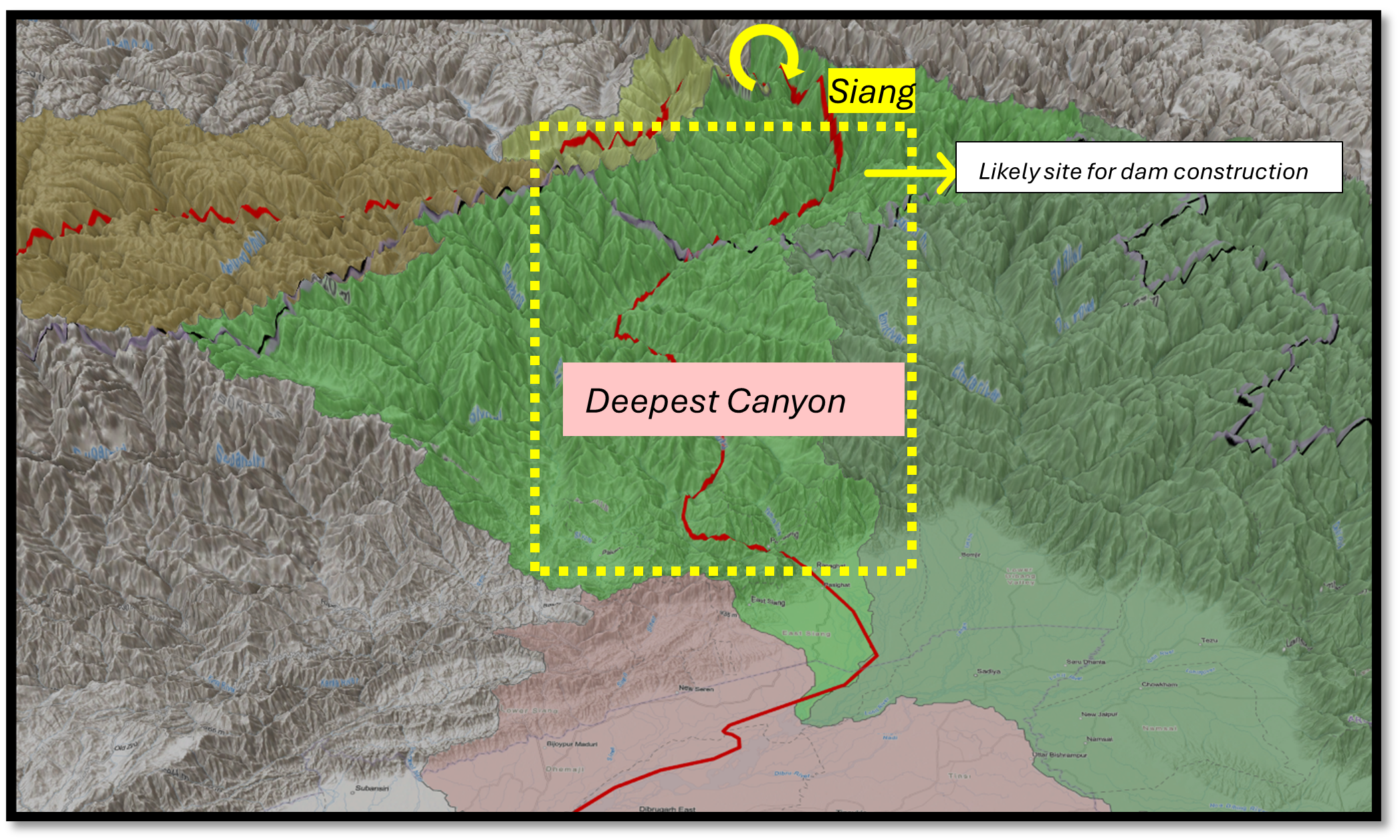
The enormous flow rate was created by the decline in elevation after the Greater U Bend when the water flow rate increased in natural gravity. The region could be the most suitable site for river runoff construction in the lower reach of the Yarlung Tsangpo. If the project is reservoir-based, with the area before the U-turn being a potential location. The utilization of natural gravity is likely the primary approach to achieve the project's estimated electricity generation capacity. The shift in land use, particularly the decline in vegetation both before the U-bend and around Medog, indicates a clear intent. However, the absence of any signs of dam toe construction leaves room for continued speculation.
4. The Yarlung Tsangpo Basin
Understanding the dynamics of an entire river basin is crucial for appreciating the intricate interplay of hydrological, ecological, and geopolitical factors that shape a river system. However, in the current discourse, the primary concern revolves around the Yarlung Tsangpo Basin (refer to Figure 3), where the proposed mega-dam project is poised to have far-reaching implications. Given its strategic, environmental, and socio-political significance, this basin warrants a more focused examination. Focusing on the Yarlung Tsangpo basin allows a more detailed assessment of the project's potential impacts, including its broader implications for downstream areas, transboundary water-sharing dynamics, and ecological sustainability.
4.1 Seasonal Flow Patterns in the Yarlung Tsangpo Basin
Understanding the seasonal flow patterns of the Yarlung Tsangpo River is crucial. More than 70% of the total flow happens during the rainy season, from June to September. The river gets its water from different sources all year long. In the dry season, from October to April, most of the river's flow comes from groundwater and water that moves underground. From April to June, melted snow is the primary source of flow. During the rainy season from June to September, the amount of water flowing off grows considerably because of rain, melting snow, melting glaciers, and the natural water flow. This leads to the highest amounts of discharge for the year. As a result, the quantity and quality of water during this time can change significantly, affecting how much water is available and how silt may be moved.
4.2 Water quality
Water quality plays a crucial role in determining the suitability of water for various human uses, including drinking, agriculture, and industry. While the basin primarily receives its water from glacial melt and monsoon rainfall, its quality deteriorates as it traverses diverse geological formations, varying meteorological conditions, and regions affected by human activities in recent times.
Previous assessments indicate that the water quality in the basin is relatively poor, with a recorded Total Dissolved Solids (TDS) concentration of 8.329 mg/L—lower than the global average for major river systems. The degradation is terrible during the wet season when peak river flow occurs. Increased sediment loads, flash floods, and runoff from surrounding terrains contribute to the decline in water quality, making it more complex to manage. Multiple water sources and varied topographies further complicate water quality dynamics.
4.3 Climate of the Basin

The Yarlung Tsangpo basin encompasses multiple distinct sub-climatic classes, as classified by the Köppen Climate Classification (1908–2016), one of the most widely used systems for categorising global climatic zones estimated based on long-term meteorological data, primarily annual and monthly averages of temperature, local vegetation and precipitation.
The Koppen climate classifications categorise the earth's places into five main climate groups and 30 different sub-climatic classes.
The more significant part of the Yarlung Tsangpo basin experiences a cold, dry mountain climate, the eastern section, beyond the Great U Bend, transitions into a warm, humid tropical monsoon climate characterised by significant rainfall. Interestingly, when the river enters India’s Arunachal Pradesh, it experiences two sub-climates: green forest and heavy monsoons.
Tibet has experienced significant climatic shifts, including changes in precipitation patterns, accelerated glacial retreat, and widespread desertification. However, the impact varies across its sub-climatic zones, as does the impact of climate change across regions. Despite these differences, the one common impact is water availability, which influences the quality, quantity, flow rate, and seasonal patterns of water reaching downstream areas in India, with ripple effects extending to Bangladesh.
The tributaries of the Yarlung Tsangpo, originating from snow-covered high mountains, are primarily fed by snowmelt. Rising temperatures and retreating glaciers threaten to alter the river’s volume and flow patterns. One such example is the study published in 2011, which reveals that “Between 1974 and 2010, the Chemayungdung Glacier experienced a 5.02% reduction in its total area, with its terminus retreating by 768 meters at an average rate of 21 meters per year. During the same period, the terminal lake expanded significantly, increasing in size by 63.7%—from 0.7 square kilometres to 1.14 square kilometres. The lake's volume also grew by approximately 9.8 million cubic meters.” Surprisingly, the headwaters of the Yarlung Tsangpo River face severe desertification due to high altitude, arid climate, and strong winds. Meanwhile, the lower reaches of the basin experience heavy monsoons, which bring different challenges like mudflow and landslides in the region.
Therefore, building a mega dam on the climate-sensitive and uncertain basin likely creates additional complexities, especially for India and Bangladesh. The risks are compounded by their vulnerability to extreme climate events and the impacts of anthropogenic activities along their riverbasins in the Brahmaputra and Jamuna rivers. These interconnected systems face cascading risks, with downstream regions, home to dense populations and critical habitats, being particularly vulnerable.
4.4 Basin’s Vulnerability to Disaster
The basin’s vulnerability to natural disasters significantly magnifies the risks. Over 600 flash flood incidents have been reported in the basin’s history, with more than 15 influencing factors identified in the river system (Fei et al., 2025). The potential for flash floods remains a serious concern due to the basin’s complex geomorphology and climatic variability. Although flash floods are less frequent in the lower reaches of the river, their occurrence cannot be discounted.

The area’s seismic activity is particularly alarming, with the past year alone recording 130 earthquakes of magnitudes four and above in TAR. This sustained seismic activity presents a continuous threat, particularly at the proposed site with high landslide susceptibility. The recent 7.1-magnitude earthquake in Shigatse Tingri caused structural deformations in nearbydams and infrastructure, further emphasising the precariousness of the area. This combination of engineering challenges, the basin’s susceptibility to multiple disasters—including landslides, earthquakes, and flash floods—and the geopolitical implications raises profound questions about the project’s long-term safety, viability, and regional impact.
The hydropower project somewhere around the Great Bend is regarded as "risky, dangerous, and irresponsible" due to several critical considerations. The dramatic elevation drop of over 2,000 metres in the Yarlung Tsangpo Canyon after the U Bend introduces formidable engineering and environmental challenges. Questions persist regarding the project’s design and methodology, mainly regarding whether it will utilise a reservoir-type or run-of-river hydropower. Such a structure could disrupt the river’s natural flow, impede the downstream transport of fertile soil, and provoke concerns about potential water diversion for China’s use—raising fears that it could serve as a geopolitical instrument under the guise of development.
4.5 Importance of Comprehensive Hydrological Data

The precipitation measured through remote sensing indicates that the river stretches around the “U Bend” and receives substantial rainfall even before entering Arunachal Pradesh. According to a World Bank report, the Tibetan Plateau averages 734 millimetres of annual precipitation, while the Yarlung Tsangpo region sees up to 2,000 millimetres. Precipitation increases significantly in the eastern Himalayas, ranging from 1,000 to 4,000 millimetres, and peaks in the Brahmaputra floodplains, with 3,500 to 4,000 millimetres annually. The Jamuna floodplains in Bangladesh receive between 1,500 and 3,000 millimetres.
The contribution of the Yarlung Tsangpo to the Brahmaputra remains contentious due to inconsistent and often outdated data. Reliable assessments require updated ground measurements of tributaries and year-round water flow monitoring to account for seasonal variations. Downstream countries like India face challenges acquiring accurate data due to limited access to upstream hydrological information.
While geospatial tools and remote sensing provide partial insights into precipitation and river runoff, they lack the precision that only detailed on-ground measurements can offer.
China’s reluctance to share consistent hydrological data has compounded these challenges, particularly amid recent geopolitical tensions. The suspension of data-sharing agreements and the failure to renew critical Memorandums of Understanding (MoUs) highlight a troubling lack of transparency. As a result, downstream nations must rely on open-source models and datasets, which reveal anomalies in river flow patterns in the Yarlung Tsang Po basin for 2024.
4.6 The Status of Run-off
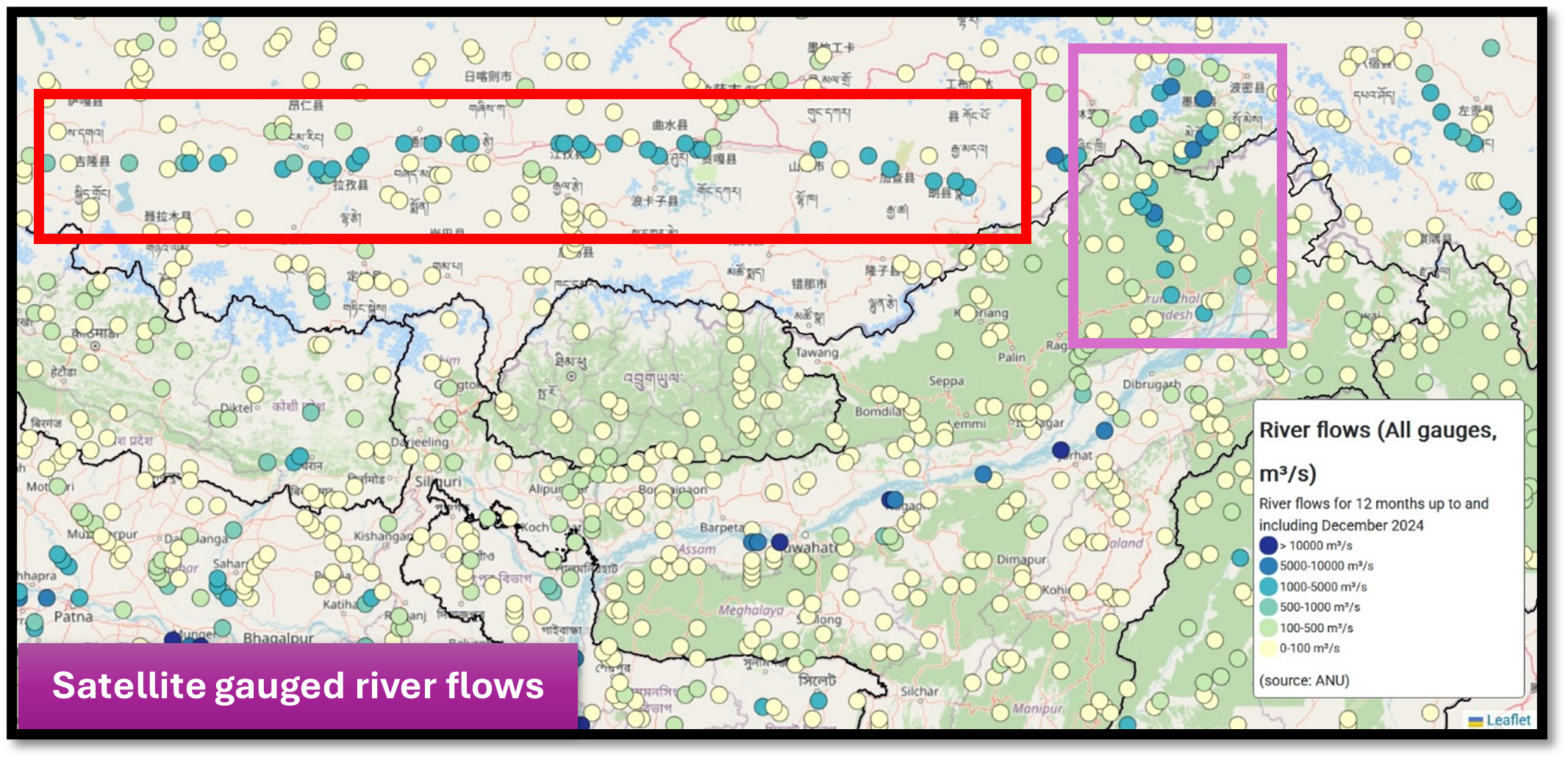
Data from the Australian National University’s 25-year remote sensing archive shows fluctuated river flow over the years in the basin, indicating potential stress on the Yarlung Tsangpo-Brahmaputra system from both climate change and upstream Anthropogenic activities in 2024 (river flow measurements at various gauges before the U-bend ranged between 3,500 and 4,200 m³/s. Closer to the U-bend, the flow increased to 5,100–5,700 m³/s, and after the U-bend, it peaked at approximately 5,800 m³/s. At specific points along the stream, the flow rate shows an all-time high in 2025, possibly due to the sudden release of water following a recent major earthquake.
China’s aggressive dam-building activities, including the proposed mega-dam on the Yarlung Tsangpo, exacerbate these concerns. These projects can disrupt natural river flows, complicating water availability and sediment transport predictions for downstream nations. The cumulative impact of such projects, combined with unreliable data, threatens the ecological balance of the river basin, the livelihoods of millions, and regional stability. Without greater transparency in sharing scientific data and collaborative hydrological studies, the long-term consequences for the Brahmaputra and its riparian nations remain uncertain.
5. Status of water storage in two distinct water bodies

Water storage levels in the Yarlung Tsangpo have fluctuated significantly in recent times. In our analysis, we examined two storage facilities for which remote sensing estimated open-source datasets are available, comparing their storage capacity over time using time series analysis. Additionally, we assessed their storage levels against historical all-time highs and the levels maintained in 2024.
The la-ang In Sutlej River, which lies within the Indus Basin just ahead of Angsi Glacier where the Yarlung Tsangpo begins, the river storage facility exhibits a discernible trend. However, five years of data show a declining trend and steeped below the long-term average (3DK data). In contrast, in the case of Yamdrok in the Brahmaputra Basin along the Yarlung Tsangpo, water storage fluctuated erratically over the past year, with all-time storage levels also varying. Unlike the Sutlej Basin, Yamdrok’s storage does not follow a clear seasonal pattern and has become increasingly skewed in recent years.
This is a concerning trend. While the Indus Basin witnessed a significant decline in water storage over the past two years, this year has seen an increase in capacity. However, the variations remain unpredictable and have become more erratic, raising concerns about long-term stability and management.
6. Spatial Distribution of Water Bodies in the Brahmaputra Basin

There are many lakes and other water bodies in the Brahmaputra basin. Some of these are in places that could cause flash floods or be affected by climate change or other disasters. Some lakes are already stressed or even ruined because of anthropogenic activities.
Looking at the whole river basin, it's clear why the Yarlung TSangpo is more important than other areas downstream. The Yarlung Tsangpo sub-basin has many water bodies on steep slopes and high elevations. The map shows where these water bodies are, focusing on their elevation and slope.
Areas with the highest risk are those at higher elevations and steeper slopes. There are clusters around Yarlung Tsangpo and other tributaries. This map is important for understanding how these water bodies are fragile and might affect downstream areas. Any changes to these lakes can impact the flow rate, quantity, and quality of water in rivers and streams further down.
7. A Defining Moment for Regional Water Politics – A parting shot
The Medog dam project, shrouded in ambiguity, embodies a crucial inflexion point in the geopolitics of transboundary water management. While its projected scale has drawn sensational comparisons to the Three Gorges Dam, the absence of transparency regarding its design, environmental safeguards, and diplomatic engagement underscores the broader challenges of unilateral hydropower expansion in ecologically sensitive regions.
Though sometimes cited as a counterpoint, India’s dam-building initiatives in Arunachal Pradesh follow a markedly different trajectory—one rooted in transparency, flood mitigation, and cooperative water-sharing mechanisms. This contrast is not merely about engineering choices but the fundamental principles governing responsible riparian behaviour. When shared river systems serve as lifelines for millions, the onus of accountability cannot be disregarded.
The question is whether China will approach the Medog dam with the same degree of responsibility and collaboration that such a project demands. Without clear commitments to mitigating cross-border risks, the project threatens to escalate regional tensions and set a precarious precedent for future large-scale hydropower developments. Until greater transparency emerges, the Medog dam remains a symbol of uncertainty—one that underscores the urgent need for dialogue, cooperation, and a shared commitment to safeguarding the ecological and geopolitical stability of the region.
The author thanks Lt Gen [Dr] Prakash Menon, PVSM, AVSM, VSM (Retd) and Air Marshal TD Joseph AVSM, VM, VSM (Retd) for giving constant mentorship, external experts and reviewer.
For regular updates on our geospatial research, stay tuned to https://takshashila.org.in/geospatial-research.
The author Dr Y Nithiyanandam tweets (X.com) @prof_nithiya
Disclaimer: Please be aware that the information and opinions provided in this newsletter are intended for informational purposes only. We advise readers to exercise their judgement and consider multiple sources of information before drawing any conclusions or making decisions based on the content presented in this newsletter.
Declaration: This article has been proofread using AI tools. Some parts of the content were published in The Diplomat & The New Indian Express.
Is there any possibility of diverting this water to Xinjiang?
👍