#11 Disclosing the undisclosed: China's Advanced firing range and probable SIGINT facilities near Shigatse, TAR
TL; DR
This report finds that a sophisticated PLA firing range near Shigatse is being used for high-altitude target practice and weapon calibration. Secondly, it finds evidence of probable SIGINT systems that can listen to a range of signals, including military and submarine communications, from vast distances.
Backstory
Have you ever wondered what an advanced firing range looks like? While media reports often mention the PLA conducting sophisticated drills "somewhere" in the Tibet Autonomous Region (TAR), this report offers the first detailed glimpse, captured through satellite images, of such a site and its major components. It can show how the landscape has evolved chronologically.
But it’s not just about the firing range. Are you curious about what kind of technology China might use for signal intelligence (SIGINT), navigation, or space situational awareness? In the second part of the report, we reveal two massive SIGINT facilities located near Shigatse along the Yarlung Tsang Po River.
This report focuses on a significant military site—likely a firing range—and two SIGINT facilities situated just 200 km from the Doklam plateau, 150 km from India’s border with Sikkim, and 30 km from the Shigatse dual-use airport. This location underscores China’s intense military preparations, where a variety of air-to-ground and ground-to-ground weapons are tested and complex target simulations are carried out. The proximity of these sites to disputed areas, including Bhutan and India’s Arunachal Pradesh, makes them critical points of interest, mainly as they sit directly along an aerial path over contested territories. The ongoing developments highlight the increasing operational readiness of the PLA forces and the expanding SIGINT infrastructure in this sensitive region.
Part I: The firing range
Firing ranges at high altitudes is essential for maintaining precision in weapon systems and calibrating older equipment, ensuring optimal performance in these unique environments. The thinner air impacts projectile trajectories, making calibration adjustments critical. Regular target practice helps recalibrate systems for use under reduced air resistance, which affects range and accuracy. For instance, the PLA’s high-altitude drills in Tibet tested long-range artillery and rocket systems for precision in low-oxygen, cold conditions. Such drills improve accuracy and integrate new and old systems for combat readiness in plateau regions.
In addition to ground artillery, air-to-ground firing is also crucial in high-altitude environments. The reduced air density can alter the trajectory of air-launched munitions, making it essential for air forces to adapt targeting systems and techniques to ensure accurate strikes. Air-to-ground training at high altitudes allows for better coordination between aircraft and ground forces, enhancing the overall effectiveness of operations. This type of training ensures that aircraft can accurately deliver munitions, even under challenging conditions, which is vital for maintaining control over strategic high-altitude regions.
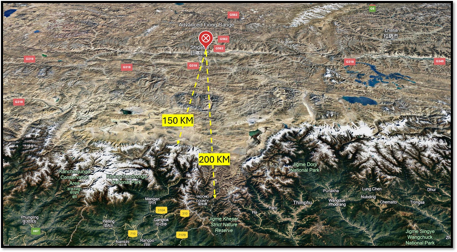
The firing range is situated at the coordinates 29°22'17"N 88°57'32" E in the flood plain of the Yarlung Tsang Po River between the confluence of two streams. The site is positioned adjacent to Highway G349, which is only 400 metres north of the firing range, and near Highway G562, which is located 12 kilometres to the east. This range is probably used for air-to-ground target practice by fighter jets and drones operating from the Shigatse dual-purpose airport or artillery firing. Its strategic location at an altitude of 3850 meters (approximately 12,631 feet) serves to assess the accuracy of targeting at higher elevations.

Large dunes, dried-up streams, and muddy tracks were the area's defining features prior to 2016. However, from July to August 2016, the landscape underwent a first sign of transformation. The initial development was the construction of a small-scale runway, measuring 200 by 50 metres, made of concrete. Subsequently, an artificial water channel was established along the western perimeter of the site, initially serving as a barrier.

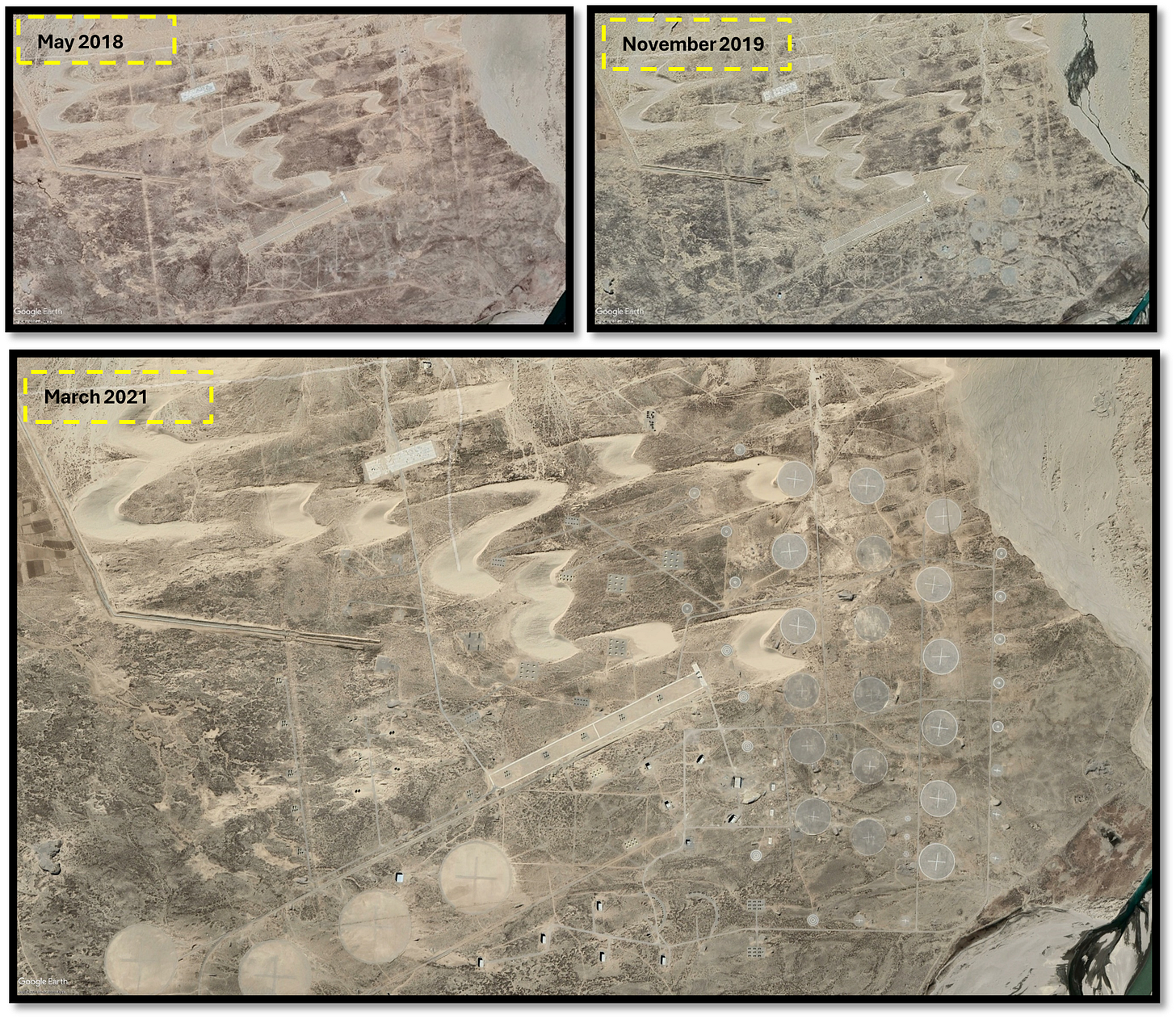
While the initial sign of construction was mushrooming in the second half of 2016, the wide range of markings on the ground evolved rapidly after the Doklam Standoff. It was a 3.13 sq. km firing range during the Doklam stand-off, which expanded to 5 sq. km in 2021. The markings are probably used to calibrate and practice on different weapon systems, possibly for air-to-ground and ground-to-ground operations. The other parts of the range are well connected with the road network, mostly demarcated muddy tracks.
The target pin surfaces are smoothed using loose soil, possibly mined from the adjacent riverbed. Over the five years from 2016 to 2021, the firing range seems to have become a testing ground for various weapons used by the PLA in high-altitude operational environments.
Within the firing range
Let us now dive into the various target simulations and markings observed inside the firing range through the lens of satellite imagery.

1. A concrete strip with fighter jets

Small concrete strips can be observed with fighter jets positioned in various places at different times, with the number of planes changing periodically. These planes, resembling the Su-30 series, appear to be decoys or old, non-functional models likely used for target practice and formation exercises. The strip is probably connected to a road network for moving the planes. Some images show destroyed planes, while others display new sets, indicating ongoing activities in the area. Despite the presence of fighter jets and other nearby assets, the strip is significantly smaller (200*50 metres) than a typical runway required for take-off and landing, reinforcing the idea that the site is primarily used for target practice. An extension piece of the concrete strip will be developed in 2024, containing hardened kinds of simulated targets.
2. Artificial water channel

A narrow channel, approximately 3 metres wide, flows into the firing range, where it ends abruptly. This channel originates from a place called Sequi, located roughly 35 Km to the east of the site. It carries freshwater diverted from the Yarlung Tsangpo River, providing an essential water supply to various villages and regions along its path.
This channel may offer a purer freshwater source than the water available in downstream areas. Along its route, the water is stored in numerous artificial reservoirs or ponds, which may serve purposes such as irrigation and domestic use for the communities it passes. The water primarily moves via natural gravity, travelling across the landscape and navigating through several barrages, confluences of larger rivers, and smaller streams. Remarkably, at one point, the channel even cuts through a mountain via a tunnel, showcasing significant engineering effort.
What is particularly puzzling is the rationale behind transporting this water over such long distances and through challenging terrain, which involves tunnelling through mountains, crossing dried riverbeds, and constructing bridges. Why the water is sourced from so far upstream, rather than utilising more accessible local water resources right next to the firing range through methods like pumping remains unclear. The reasoning behind this intricate water transport system is still a mystery, leaving questions about its intended purpose and the motivations behind its design unanswered.
3. levelled strip
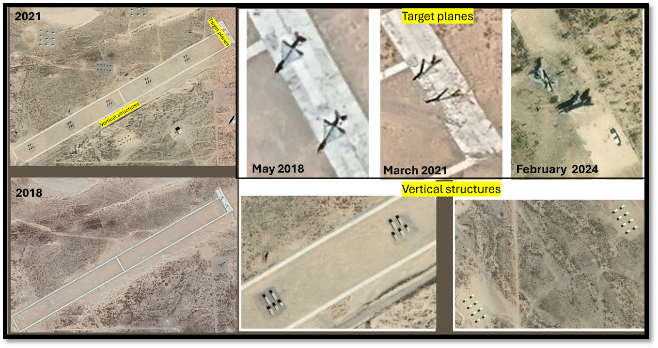
A levelled strip, measuring 1300 metres in length and 50 metres in width, is in the centre of the firing range. On one side of the strip, there is a section measuring 140 metres in length and 30 metres in width, where dummy aircraft were positioned. In 2018, two aircraft were placed in this area, pointed in a specific direction and good condition. However, satellite images from 2021 reveal that the aircraft has sustained damage. One appears to have been dislocated, with parts scattered along the direction of the hit. Subsequent photos show the aircraft becoming increasingly disoriented and displaced over time, indicating that target practice has been conducted regularly.
Additionally, the strip is dotted with vertical structures arranged into five distinct clusters, each spaced approximately 200 metres apart. Each cluster contains five vertical pillars: two in the front row and three in the second row. The land around the clusters has been levelled and paved with concrete, and vehicles have occasionally been spotted next to the clusters. There are five clusters with 25 vertical pillars on this strip extending east to west. Meanwhile, another five clusters with 25 vertical pillars are evident in the linear structure from north to south. Below the strip are two more clusters, each with ten vertical pillars.
While the vertical pillars have remained intact over the years, the condition of the aircraft and their wreckage has varied, with vehicles appearing intermittently in the area.
4-6. Target pins of varied size

At the firing range, circular target markers of various sizes are observed. The site had a circle with a 100-meter radius and rectangular markings around it in November 2017. Initially, there were also four 50-meter radius circles and some concentric circles in the southeastern corner.
Post-Doklam, significant changes were noted. By 2021, the number of large circles increased to four, each with a 100-meter radius and distinctive (+) marking. Furthermore, 18 circles with a 50-meter radius and several smaller circles with a 15-meter radius, all marked centrally, were also present. In addition, six of the 15-meter radius circles included concentric rings at 5, 10, and 15 metres within them.
This arrangement has been consistently maintained, with annual upkeep. Occasionally, the orientation of the markings is adjusted. Craters within the circles are subsequently filled as part of site redevelopment, indicating that regular target practice is conducted. These targets are not merely superficial but reinforced to endure sustained firepower. The circles with markings probably indicate air-to-ground targeting simulations and ground-to-ground calibration of weapons.
Most of the circular targets are concentrated on the eastern and southern sides of the range, with rivers bordering both ends of the area.
7. Array of structures

A network of roads that resemble arteries connects the various target patches set up in this area. There are over ten distinct patches, some situated near dunes, possibly providing protection. Each patch contains a group of structures spaced evenly apart, typically by 8 to 10 units. The number of structures in each patch varies, ranging from 8 to 10, and they are positioned in different orientations.
Some structures resemble individual houses, while others resemble probable artillery units. Notably, the number and arrangement of these structures are inconsistent across satellite imagery from different periods. These patches are located centrally within a firing range and may be used for various target practice simulations.
8-10. Mix of functional objects and decoys

The image highlights several large individual structures positioned at various points along the roads and road extensions. It also shows target simulations, including vehicle convoys arranged linearly. Notably, a significant structure marked as number 4 in the June 2024 image appears to be a large aircraft hangar, possibly constructed with durable materials and serving as a storage facility or a simulated target like a hangar.
The structures are identified as follows: number 1 refers to individual structures, numbers 2 and 3 represent individual vehicle convoys, while numbers 4 and 5 denote larger structures, potentially simulated targets or storage areas. Numbers 6 and 7 indicate recent changes in the convoys' positions and placement.
Comparing the August 2000 image with the June 2024 image reveals variations in the positions of these structures. Notably, some of these structures are active, not merely decoys. The vehicles and specific structures emit electronic signals, suggesting they are functioning units rather than static or inactive targets. This part of the firing range in the southwest section appears highly active, likely simulating scenarios that change periodically based on operational requirements.
11. Few other features

In addition to the main features previously described, there are a few more minor, unmarked elements worth noting. Three pairs of radars are positioned adjacent, along with two pairs of mobile launchers, all within an area of approximately 1,000 square metres. The radars are spaced less than 10 metres apart, and the launchers are about 10 metres apart, suggesting they might serve as decoys rather than active operational units.
Four concrete pads are visible outside the firing range on the northwest side near a river junction. Despite having markers and roads connecting them, the purpose of these patches is unknown.
Scattered throughout the area are several destroyed structures, with damaged objects and simulated features related to air operations and ground infrastructure. These appear to be used as targets during training exercises.
The monitoring station

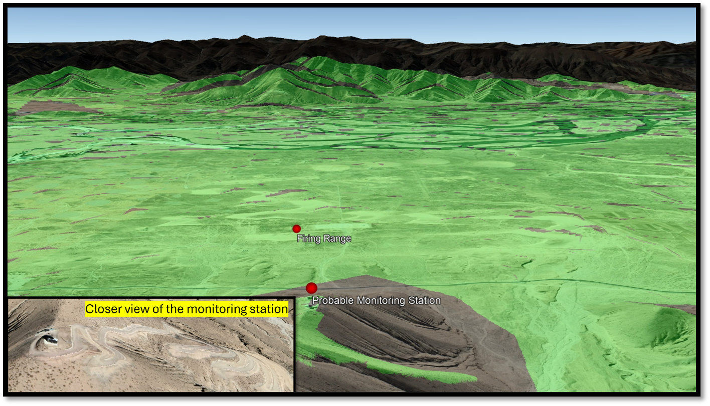
The Probable Monitoring Station is located at 4025 metres, right next to the highway and facing the centre of the firing range, which is at 3835 metres. This elevated position gives the station a clear view of the firing range.
View shed Geospatial analysis helps to determine the coverage area using 3D data, with the results displayed in green. The green areas represent the visible areas from the highest point. Considering the station's location, elevation, antennas, road construction, and existing facilities, this is likely a monitoring station for regular firing exercises.
Is this an active firing range?
While studying the developments in the firing area, a big question remains: When were these sites active in the past, and are they still functional today? We used techniques adopted in our previous studies based on remote sensing inference to find some answers. These findings reveal some interesting things, which are explained below.


A space-based approach to monitor ground activity instead of relying on traditional SIGINT methods is used. This allowed us to observe changes throughout the year. In 2017, certain areas of the range were highly active, but from 2018 to 2021, the activity gradually decreased. From 2023, the activity began to increase again, sometimes holding steady until early 2024 before declining slightly. However, overall activity levels remained high. The range is most active from May to August, with August seeing the highest usage, followed by July. Over the years, operations have primarily occurred between May and August, with occasional activity extending into September. August is consistently the busiest month, although shifting patterns may reflect weather changes or other schedule factors.
It is important to note that the above analysis is based on observations of specific sections of the firing range. It relies on limited open-source satellite imagery, which may not fully or accurately reflect the actual extent of exercises conducted. Corroboration with additional intelligence sources is recommended for a more comprehensive and accurate interpretation.
Part II: Probable signal intelligence (SIGINT) facilities
While exploring places around the firing range, we noticed some interesting structures. These might be advanced signal intelligence facilities with broader utilisation and military importance beyond the firing range.
Site A

The site is situated about 6 km west of the firing range and 38 km west of Shigatse Airport, at an elevation of 3,840 metres. Positioned along the banks of the Yarlung Tsangpo River, directly across from Shigatse City, the feature has an approximate radius of 180 metres and a circumference of around 1,134 metres.
The physical characteristics of site A without fingerprinting it are as follows:
Circle and Antenna Placement:
· First Inner Circle: The innermost circle, located 50 meters from the centre, is populated by 40 evenly spaced antennas around its circumference.
· Middle Circle: The middle circle, sitting 100 meters from the centre, acts as a boundary for the area between the inner and outermost circles.
· Last Outer Circle: The outermost circle, situated 170 meters from the centre, contains 40 antennas along its circumference, completing the outermost layer of the structure.
Radial Divisions:
The area between the centre point and the inner circle and between the inner and middle circles is divided into five segments by radial lines extending from the centre. These lines create distinct zones within these circles. Further, the image shows the structure divided into 16 equal segments by radial lines extending from the middle circle to the outer perimeter, creating additional distinct areas.
Central Elevated Structure:
At the centre of the feature is an elevated circular structure with a radius of 8 meters, constructed in 2018. This central feature stands out prominently within the design.
Site Development History:
· The site was initially a flat riverside area before construction began in June 2017. The first construction phase occurred in the middle of this space, where a small, circular, elevated structure was built.
· By mid-2018, the land had been cleared and levelled, with the outer circle completed first. Following June 2018, more sections were marked out, and the full-fledged antenna system was rapidly developed.
· Throughout 2018, additional circular divisions were completed, and the antennas were systematically installed in their respective positions, forming the comprehensive structure seen in the image.
Inference:
The physical features seen were similar to those of SIGINT systems around the world, which suggests that this might be a circularly disposed antenna array (CDAA) system used for high-frequency direction finding (HFDF).
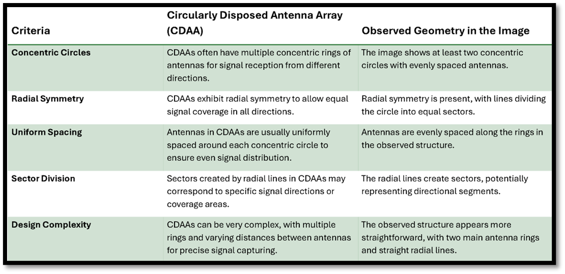
The CDAA system, created during the Cold War, is a tool used to intercept and locate signals. The US military has widely used it to find signal sources worldwide. The Soviets also developed similar systems back then. The CDAA works best between 3 and 30 MHz using two circles that scan signals in all directions to find the best way to intercept transmissions. This system is more compact than large antenna farms, which need much space and must be moved around in different directions.
Many countries have used this system, and recent studies show that China is now using old World War II tools to find and listen to signals from various directions. One study, mentioned in a CSIS document, highlights China helps to build such a facility in Cuba to listen to military activities in the United States.
Since the HFDF system relies on skywave propagation through the ionosphere, it can intercept signals over vast distances, sometimes spanning continents.
In the meantime, another site connected to SIGINT has been identified and is referred to as Site-B.
Site B

A facility with a control centre in the middle and three semi-circular boundaries containing antennae is located between the firing range and the CDAA system. It is approximately 4 km from the firing range and 1.3 km from the CDAA system, at an elevation of 3800 m. The first construction phase began in early 2017, during which the control centre was being developed and the road connecting this site from the highway was laid out. The satellite image of May 2018 shows that construction was halfway completed, but it was expedited and finished by the end of 2018. The control centre is covered with high walls, indicating its importance. Communication dish antennas are also present.
Main Structure:
- A rectangular central building, likely housing control equipment, sits at the top of the image, surrounded by a perimeter fence with road access from the upper left.
Antennae Layout:
- Multiple antennae extend from the central structure in a radial pattern, forming clusters that create semi-circular patterns around the facility.
Semi-Circular Pattern:
The antennae are organised in semi-circles:
- Inner Semi-Circle: The first semi-circle closest to the building contains approximately nine evenly spaced antennae.
- Middle Semi-Circle: The second semi-circle contains approximately 18 antennae, extending further outward.
- Outer Semi-Circle: The final, outermost semi-circle contains around 33 antennae, making the rods longer and covering a wider area.
Orientation:
- The central structure is positioned at the top (North), with the antennae spreading in a fan-like formation toward the southern part of the installation (facing south).
Number of Antennae:
- The three semi-circles collectively contain approximately 60 antennae, with increasing length as they move outward.
Overall Layout:
- The radial pattern suggests the array is designed for focused data collection, possibly for military, astronomical, radio frequency monitoring, or scientific research purposes.
Inference:
Given the physical features of the antenna array, there are some possibilities that it could be a Very Low Frequency (VLF) system. VLF systems typically require extensive infrastructure to support highly long wavelengths (3–30 kHz), often consisting of tall masts or extensive wire arrays spread over vast areas. The semi-circular arrangement of this array, with clusters of approximately 9, 18, and 33 antennae in progressively larger arcs pointing towards one direction, suggests a design for signal directionality rather than omnidirectional VLF communication. Given the size of the system, this may be designed for 1 MHZ – 1 kHz; however, it may vary.
The radial, organised pattern could be an adaptation to maintain precision in transmitting or receiving low-frequency signals. If this array were intended for VLF applications, the layout could represent a more modern or compact version, where multiple concentric rings of antennae help focus or distribute very low-frequency signals for specific tasks—primarily used for long-distance communication, particularly with submarines or applications requiring signals to penetrate through water or ground. Due to their low frequency, these signals are robust but limited in data capacity.
Notable developments in a nearby village

As we analyse the activities at the firing range and the SIG-INT facilities, it's crucial to consider the surrounding areas. Shigatse, a city with a significant military presence, was previously studied for infrastructure developments at Shigatse airport, Heliport developments, and changes in its urban area. This time, we will focus on Dalongda, the nearest village to the examined sites, located just above the firing range and signal intelligence facility. Significant changes have occurred in this village over time. In 2018, a structure storage facility was constructed, and it has recently transformed into an entire military complex. This indicates ongoing developments and the establishment of supporting facilities in the vicinity.
Parting shot
While firing ranges are a standard component of military operations, their significance intensifies when the People’s Liberation Army (PLA) conducts activities near the Line of Actual Control (LAC) with India. This highly militarised area has fighter jets, UAVs, helipads, and a robust military presence. Still, it is also aligned with critical locations like the Doklam Plateau and India’s 'Chicken Neck' corridor. The proximity of such sensitive regions underscores the importance of these developments. Construction and militarisation activities, particularly since 2018, align with shifting geopolitical priorities. By 2021, much of the infrastructure was completed, with further refinements observed up to 2024, including the reconstruction of targets and the introduction of new shelters and decoys. Although some equipment, such as fighter jets, may not be fully functional, electronic intelligence systems indicate ongoing operational readiness. The precise positioning of radars, shelters, and convoy targets suggests evolving tactical strategies to replicate real-world combat scenarios. The type of weapon being used in the firing range is unclear. Typically, firing ranges have targets at a distance, so it's not clear whether air-to-ground or ground-to-air weapons are being used. However, it's possible that precision weapons are being tested using UAVs and that precise ground-to-ground weapons are being calibrated.
Meanwhile, the SIGINT infrastructures mapped in the report are vital for aviation, space situational awareness, air operations, and, most importantly, military signal intelligence. These systems intercept both high- and low-frequency signals, with the HFDF capturing signals bouncing off the ionosphere and the VLF systems monitoring ground-based propagation extending as far as the Bay of Bengal, tracking potential marine and naval activities. This facility is likely part of a more extensive, global network of similar installations designed to monitor intrusions and gather intelligence on military and civilian operations. Though the exact nature of its operations remains uncertain, the infrastructure appears fully operational and continually expands.
Many might wonder why China would invest in these seemingly outdated signal intelligence systems, which most of the world has moved away from. However, recent developments, such as a 2024 CSIS report detailing China’s construction of a similar facility in Cuba to monitor U.S. military activities, indicate this is part of China’s broader strategy. This network of installations reflects a deliberate investment in traditional signal interception, possibly augmenting modern technologies.
The proximity of this facility to critical areas near the LAC highlights its strategic importance. While geospatial data suggests it could serve as both a firing range and a signal intelligence hub, further intelligence corroboration is necessary for a complete understanding of its function. The fact that China continues to maintain and operate these facilities demonstrates their importance in modern intelligence operations, where the fusion of old and new systems provides comprehensive surveillance capabilities. The proximity to crucial military zones only adds to the significance of this installation in regional and global military dynamics.
These developments underscore the PLA's extensive preparations and highlight the need for effective countermeasures. Understanding the scale and nature of these exercises is crucial for assessing the PLA’s military readiness and crafting appropriate responses. This facility’s presence in such a geopolitically sensitive region reinforces its role as a key player in China’s strategic intelligence operations, making it a significant factor in regional stability and global security.
Cite this article as: Nithiyanandam, Y. “#11 Disclosing the undisclosed: China’s Advanced firing range and probable SIGINT facilities near Shigatse, TAR.” Takshashila Geospatial Bulletin, 7 Oct. 2024, geospatialbulletin.takshashila.org.in/p/11-disclosing-the-undisclosed-chinas.
The author thanks Lt Gen [Dr] Prakash Menon, PVSM, AVSM, VSM [Retd] and Air Marshal TD Joseph [Retd] for giving constant mentorship, external experts and reviewer.
For regular updates on our geospatial research, stay tuned to https://takshashila.org.in/geospatial-research.
The author Dr Y Nithiyanandam tweets (X.com) @prof_nithiya
Disclaimer: Please be aware that the information and opinions provided in this newsletter are intended for informational purposes only. We advise readers to exercise their judgement and consider multiple sources of information before drawing any conclusions or making decisions based on the content presented in this newsletter.

