#10 High-Altitude Hubs: The Strategic Heliports Shaping Tibet's Military Landscape
TL;DR
- Heliports and helipads are strategically placed at key locations and near the LAC, serving as logistics hubs to enable rapid troop and equipment movement.
- Nearly 90% of helipads are situated at elevations between 3300-5300 meters, with 80% between 3600-5300 meters, highlighting their key positions.
- Helistrips are being expanded to accommodate UAVs that can land on strips shorter than 1000 meters, enhancing their utility in case of rotorcraft limitations.
- Despite these high-altitude positions, their operational capabilities remain unclear.
- The slower pace of heliport construction compared to airfields suggests the PLA's priorities under the Western Theater Command.
Backstory
Over the past ten years, the People's Liberation Army (PLA) has significantly expanded its military infrastructure and presence in the Tibet Autonomous Region (TAR) and Xinjiang, part of its Western Theatre Command. Of particular importance is the strengthening of the PLA's Army and Air Force infrastructure in TAR, aimed at high-altitude operational capability. This is a strategic move to match or gain superiority over India in the region.
The PLA's sustained focus on bolstering its military presence and building infrastructure in these areas has significantly increased its operational capabilities. The developments in the Tibet Autonomous Region (TAR) have enhanced civilian activities and augmented military operations. From India’s point of view, it is important to note the advancements in air infrastructure, which have attracted attention from researchers and analysts, especially in the aftermath of the 2017 Doklam standoff and the 2020 Galwan Valley clash. These infrastructure enhancements could impact India and other neighbours in a conflict.
Our earlier analysis published in Takshashila Geospatial Bulletin’s fourth edition used advanced high-resolution satellite images to examine TAR's air infrastructure, especially. The study focused on detailing significant military developments at large regional airports. At the same time, other researchers concentrated on fighter aircraft and missile sites. Both heliports and helipads are of equal importance.
Our current investigation thoroughly examines the developments within the helicopter force in the TAR. This includes assessing:
a. Changes in existing heliports
b. The establishment of new heliports and helipads
c. The spatial connections and interrelationships with other infrastructure and developmental activities around each site.
We have chosen eight locations that contain valuable and informative data pertinent to military matters. This analysis aims to understand the multi-dimensional role of helicopter infrastructure in PLA's high-altitude operations.
We will, however, not delve into the technical aspects of helicopter lift capabilities and deployment, as its scope is focused on Geospatial Intelligence (GEOINT).
The Role of Helicopters in the Western Theatre Command
PLA’s WTC are equipped with various modern helicopters. Among these are attack helicopters designed for combat purposes and helicopters suited for medium and heavy operations. Notably, the Z-21 heavy attack helicopter stands out as a modified Z-20 utility helicopter. Resembling the American AH-64 Apache, the Z-21 boasts advanced weaponry, enhanced high-altitude capabilities, and reduced infrared signatures, making it a formidable asset in military operations.
Monitoring and examining the establishment and development of heliports and pads at strategic locations is essential. This initiative will likely bolster logistical capabilities, facilitate rapid deployment, and enhance operational efficiency in high-altitude and border regions for any military. The infrastructure supports their strategic objectives by enabling swift troop and equipment movement, which is crucial for maintaining and expanding influence and military readiness in contested and challenging terrains.
In the case of TAR, helicopters under the Western Theatre Command (WTC) play a multifaceted role. They are indispensable for tackling the logistical and transportation challenges posed by the region's high-altitude terrain, where road infrastructure is often insufficient. In addition to providing essential support for combat operations, including close air support, troop insertions, and medical evacuations, PLA’s rotorcraft power offers crucial support in navigating the region’s challenging terrains.
The Chinese helicopters deployed in the WTC include the Z-20, a domestic medium-lift helicopter resembling the UH-60, capable of essential troop transport, sling loads, fast-rope insertions, and hoisting operations. The Z-8, with variants such as Z-8G and Z-8L, provides heavy lift capabilities, with the Z-8L having a wider fuselage for a broader range of military equipment. The Mi-17, with variants that include Mi-171SH, Mi-17E, and Mi-17-V7, serves utility, transport, cargo, and armed roles, notable for its high-altitude performance with the VK-2500 turboshaft engine (a Russian-made engine developed and produced by UEC-Klimov, part of the United Engine Corporation (UEC) under Rostec, a Russian state corporation).
Interestingly, the PLA’s induction of the Z-20 and Z-8L helicopters aims explicitly to enhance performance under challenging conditions. It is commendable that such efforts are being made, even if their practical value remains questionable. The operational information available in the public domain about these machines is limited and, when available, often perceived as unreliable.
Admittedly, the PLA's commitment to develop extensive infrastructure, including the rapid construction of heliports and the upgrade of existing facilities, underscores its dedication to supporting and strengthening its regional capabilities in the TAR.
Now, let’s delve into the spatial distribution of helicopter infrastructure in TAR.
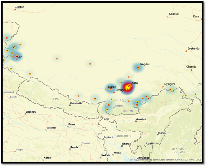
The study identified over 100 helipads in the TAR, as illustrated in Figure 2. These helipads are positioned in four primary areas:
A. Locations with significant infrastructure.
B. Strategic points near borders.
C. Disputed or occupied territories with PLA presence.
D. Major logistics hubs.
The data presented in Figure 3 indicates that most helipads are concentrated in two primary areas: Lhasa and near Aksai Chin. Lhasa has the highest number of helipads, thanks to its well-established heliport and airbase with dedicated helicopter infrastructure. The Aksai Chin region, located west of TAR, hosts numerous helipads, reflecting its strategic significance and role in supporting the PLA's ground forces in this contested area. Beyond these main clusters, the region also encompasses smaller groupings of helipads situated along water bodies, near key logistics hubs, and in other pivotal locations, thus forming an extensive and interconnected network of aerial support.

The research analysed 109 helipads based on their elevation, and the results unveiled interesting distribution patterns. Surprisingly, only two helipads are positioned at elevations ranging from 780 to 2600 meters. However, 32 helipads are located between 2700 and 3600 meters, 44 helipads between 3700 and 4300 meters, and 25 helipads between 4400 and 4700 meters. Of particular note, six helipads are positioned at elevations between 4800 and 5400 meters. These helipads exhibit a wide range of elevations, from a minimum of 780.50 meters to a maximum of 5374 meters, with an average elevation of approximately 3930 meters.
This research has mapped the locations of heliports/helipads and their crucial role in facilitating ground movements, transporting personnel to remote military locations, and supporting various tactical operations. The strategic selection of helipad locations is particularly evident at higher elevations, where optimal vantage points are vital for effective military operations. Although most helipads are concentrated between 2700 and 4700 meters, it's essential to acknowledge the presence of helipads at both higher and lower elevations. This distribution emphasises the significance of mapping out the operational capabilities of helicopters across diverse terrains, ensuring adequate support in various environments.
The elevation of the helipads and by knowing the inventory of helicopters in the WTC offers valuable insights into the operational conditions and the types of helicopters likely to be deployed in those areas. This understanding is crucial for assessing helicopter models' efficiency and operational requirements, particularly the new attack helicopters and the commonly used Mi-17 series. It indirectly suggests the specific types of helicopters that are most likely to be deployed at different altitudes.

Figure 5 illustrates the locations of helipads and heliports, highlighting their concentration near the Line of Actual Control (LAC). We employed a linear buffer to assess the proximity of helipads and associated infrastructure. The map contains the location of helipads, heliports, and airports (which probably serve as multipurpose facilities that can accommodate helicopters and UAVs in addition to planes). The infrastructure is notably concentrated at these critical points while also being dispersed across areas of interest.
There is a suspicion that these helipads and heliports may be for more than just helicopters. There are concerns that certain types of UAVs used by PLA forces might also operate from these locations. Therefore, a comprehensive examination of all features associated with these aviation facilities, including helipads, heliports, runways, and heli-strips, is necessary to extract information about their development in critical areas.
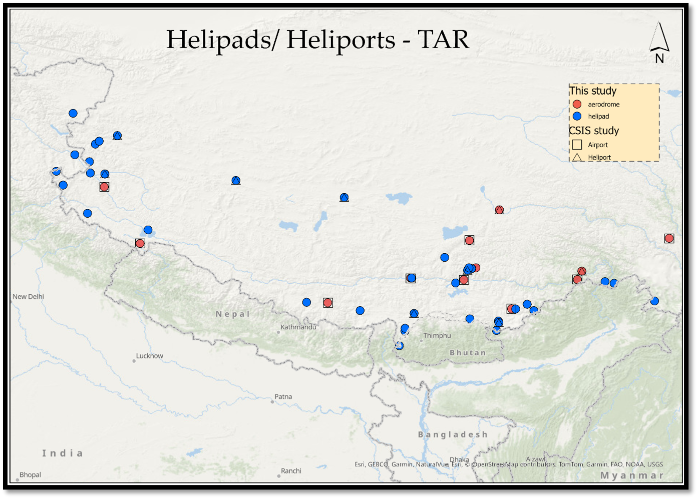
A previous study by the Center for Strategic and International Studies (CSIS) provided valuable insights into TAR's development, highlighting the establishment of several heliports and airports in the region as of 2022. However, this study further maps out the smaller military helicopter landing facilities and helipads within these heliports and airports. Figure 6 showcases the rapid development of TAR since 2022. While the CSIS data primarily focused on significant heliports, our analysis delves deeper by including the newly established smaller helipads. We have pinpointed each helipad in the region, especially those at critical locations and those that have military significance. Our study adds to the existing CSIS findings by identifying more development locations, offering a more comprehensive understanding of the region's air infrastructure. The new features uncovered in our study emphasise the necessity of recognising the significant heliports, airports, and smaller landing facilities crucial for military operations.
Analysis of selected sites that contain crucial helicopter-related infrastructure
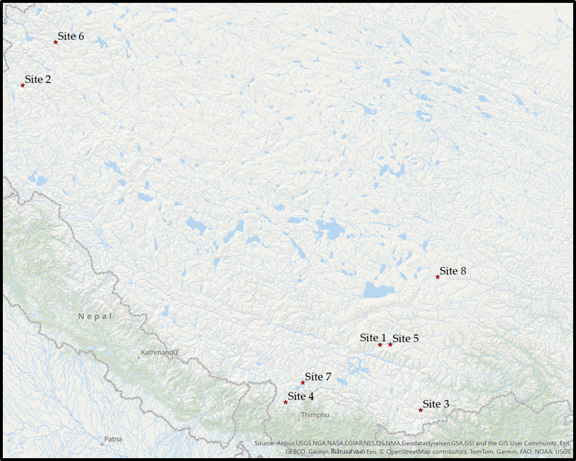
Our study selected eight locations with unique scenarios to explore the various factors and potential uses more deeply. Through a detailed analysis of these diverse scenarios, we aim to comprehensively understand these helipads' strategic importance and broader implications for military operations.
Site 1 - GB_HE_47

The facility is situated at nearly 4,000 meters on the riverbanks. It includes a Heli strip measuring 845 meters long, accommodating UAV landings. Over time, the facility has expanded to include over 14 helipads, several operational hangars, and zones designated for testing and practice. Ten helicopters were found during imaging, and some were identified as Mi-17s. This is one of the largest heliports in the region, equipped to handle helicopters, UAVs, and various military vehicles. Observations reveal multiple helicopters on-site, including attack helicopters and those used for logistics. The facility boasts Satellite Communications (SATCOM) capabilities and a control centre identifiable by specific markings. In the top right corner of the image, a fully operational residential area with an indoor stadium is visible, likely providing amenities for the personnel.
Adjacent to this residential zone is a storage facility, likely intended for fuel, and is currently under construction. On the eastern side, a city surrounded by mountains is taking shape, featuring high-rise buildings, recreational areas, and extensive sports facilities, all supported by significant road infrastructure. The foothills are reinforced with materials and structures to prevent landslides. This heliport is a Lhasa access point and hub and supports several military operations. The surrounding area includes multiple tunnels that facilitate highway passage through the mountains. Despite its riverside location, the heliport is strategically positioned to support critical operations in the region.
Site 2 – GB_HE_51
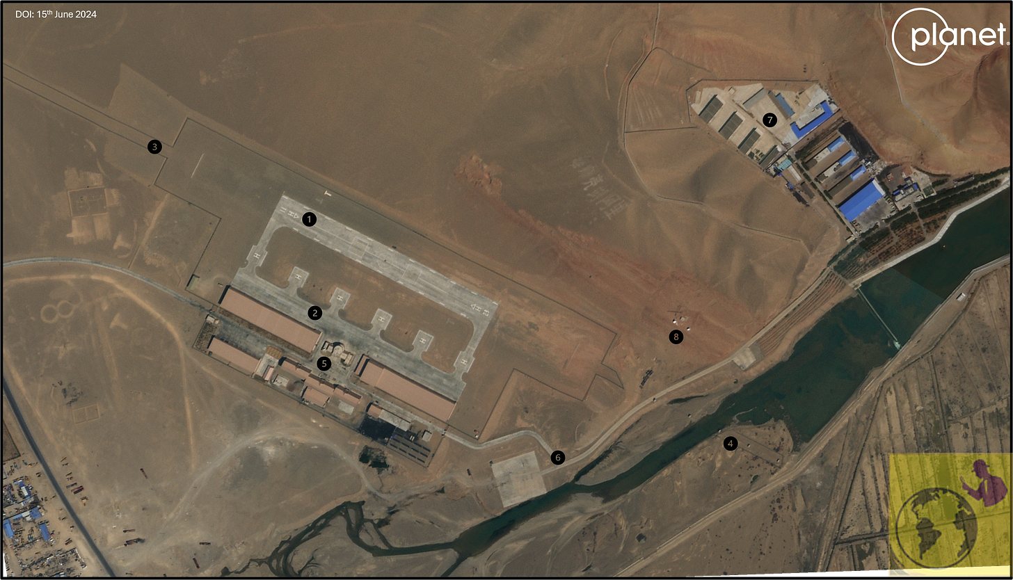
An image dated June 15, 2024, reveals an under-construction heliport with dual-purpose facilities with significant strategic implications. This heliport, strategically located just 60 km from the disputed territory between India and China, features a 400 meters strip expandable up to 700 meters at an elevation of 4300 meters. The facility's potential utility is noteworthy, given its proximity to the conflict zone. The strip is designed for emergency and forward landings and is equipped with approach passes and lighting to facilitate night and extreme weather operations, highlighting the need for preparedness in all conditions. The image also shows radio communication towers and air traffic control towers, which are essential for managing the complex operations expected at this site. Retaining walls have been constructed to protect against flooding from the nearby river.
Additionally, the heliport is well-connected to Highway 3219, enhancing its accessibility and strategic value. Extensive military activities surround the heliport, including new constructions, training exercises, and troop movements. The site's location amidst mountain peaks provides natural cover for these operations, further emphasising its strategic importance in the region.
Site 3 – GB_HE_19

The site, located at an elevation of 3,950 meters, has gained significance due to its functional Surface-to-Air Missile (SAM) site. What was merely a piece of land in 2018 has been transformed into a fully operational SAM site complex, complete with administrative buildings, accommodations, recreational facilities, etc. The adjacent land under development is likely being prepared for a heliport, with dimensions ranging from 200 to 250 meters. This new facility is just 100 kilometres from Tawang, near the India-China border in Arunachal Pradesh. The site is geographically positioned at a lower elevation and benefits from good road connectivity. Current excavation activity suggests that the soil may be used for land reclamation or potential underground operations, though this remains to be conclusive based on available imagery. Additionally, Site 3, located near the river and close to the city of Lungze, also holds strategic importance.
Site 04 – GB_HE_96

The helipad, located at an elevation of 4276 meters, appears to be an older facility than others we have observed. Although it is not a heliport, this helipad holds significant strategic value in the region. The image above shows that the military building complex is in a remote area; hence, the helipads likely serve as an essential transportation and logistics hub for nearby installations, including the PLA's PAGRI SAM site, which is just 1.5 kilometres away. This site is just 8 kilometres from the Bhutanese border and 16 kilometres from the disputed area between Bhutan and China north of the Dhokla plateau. The area around the helipad is bustling with military activity, as evidenced by numerous trenches, footprints, tyre tracks, temporary military installations, and probable craters created for military operations. Close to Nagadong and 28km east of India’s Sikkim, this helipad is pivotal due to its strategic location.
Site 05 -GB_HE_08
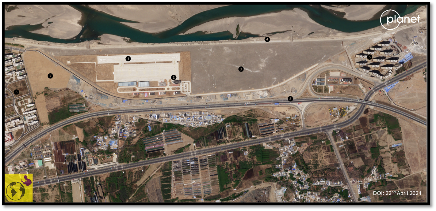
The site depicted in the above image is at an elevation of 3674 meters, nestled in a valley adjacent to Highway G318, which connects Lhasa and Nyingai. This is the second heliport we've examined in Lhasa, positioned right on the banks of the Lhasa River. The heliport features a 550-meter Heli strip and a 400-meter tarmac with fully functional systems. However, no helicopters were observed at the time of imaging. The surrounding area is experiencing substantial development, with high-rise apartments and fully operational community centres to the west of the site. Although expansion efforts have been stagnant for some time, ample land within the heliport complex exists for further development. The infrastructure suggests that the heliport may be used for UAV landing and operations. Despite a retention wall near the river, the heliport and the expansive Lhasa River are nearly at the same level. The absence of landing guidance indicates that the heliport will be operational only under limited circumstances.
Site 06 -GB_HE_34
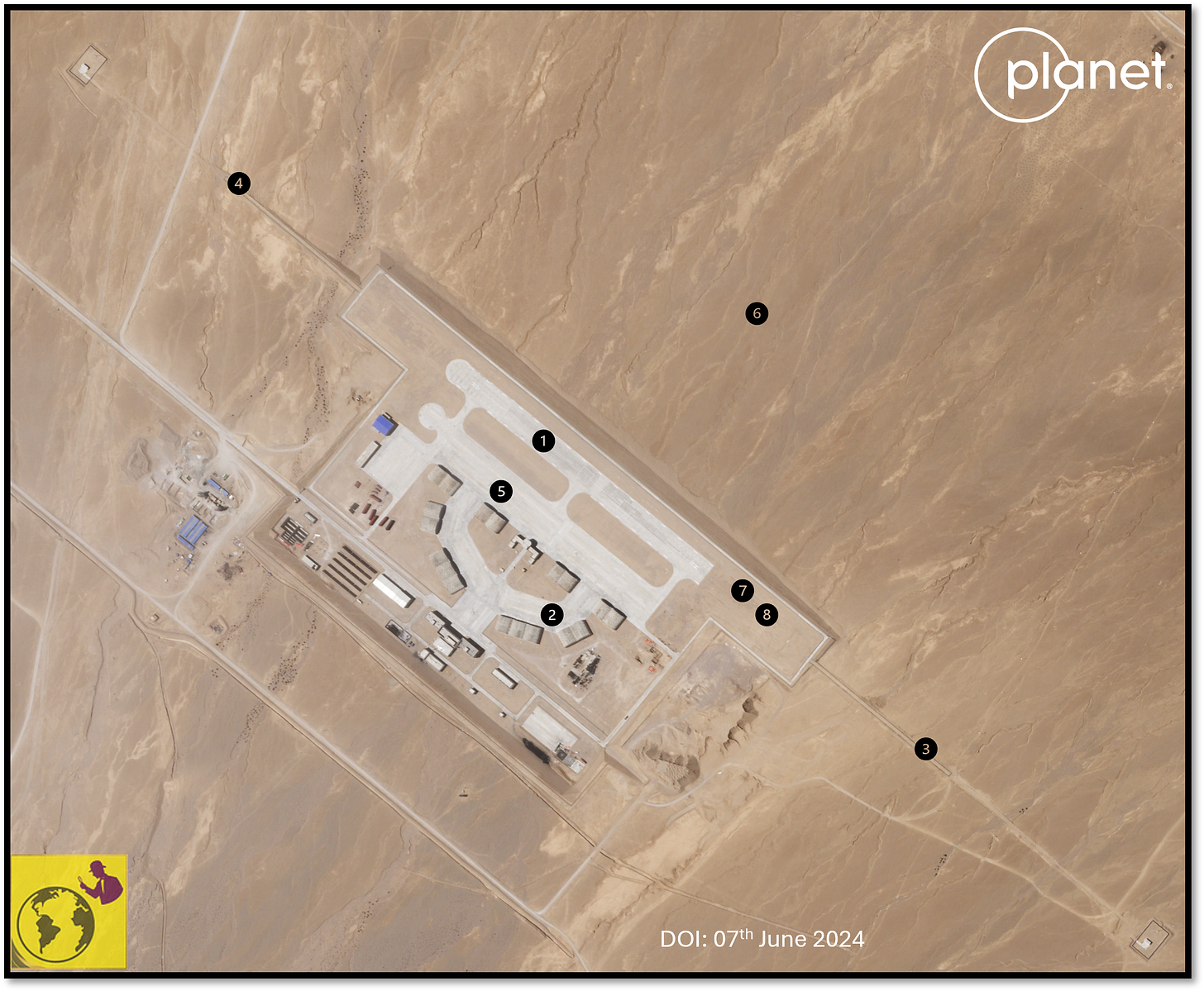
The heliport shown above is different from others we've seen so far. It is located next to Highway G219, which leads to Pangong Tso Lake and has no nearby towns, indicating its use for military operations. This heliport is built on a mountain slope with reinforced land to enhance its stability and is designed for military operations. It includes 18 probable hardened shelters and is positioned just below a dried river, providing natural protection from direct threats due to its lower elevation relative to the riverbank. This heliport's location and unique topography make it particularly interesting, as it is close to contested areas. The facility consists of two heliports with equally long Heli strips, each about 650 meters long and equipped with approach lights and other facilities suitable for various conditions, including night-time landing. These Heli strips can also support UAV operations in the region. The area around the heliport is bustling with military activities, making this a significant site to monitor during times of tension between India and China.
Site 07 -GB_HE_66
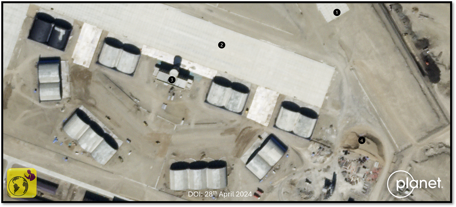
Perched at an elevation of 4,426 meters, this cutting-edge heliport is meticulously crafted to cater to both helicopters and UAVs. Comprising two runways, each spanning from 500 to 600 meters in length, with provisions for expansion up to 1 kilometre, the facility reached a significant milestone with the completion of its second runway by late 2023, greatly amplifying its operational capabilities. Boasting over 16 shelters and hangars, the heliport is a mere 63 kilometres from the Indian border and 23 kilometres from the Bhutanese border, nestled between the stunning Lake Kala and Lake Mabu. Furthermore, its proximity to a radar station, equipped with a pair of radars atop a nearby mountaintop just three kilometres away, adds to its strategic allure. This state-of-the-art facility is also conveniently situated near a modern village approximately two kilometres away, with the added advantage of being closely linked to Highway 219, thereby becoming an integral part of regional developments. The significant presence of military indicators in the area further underscores the importance of heliports. Evolving with time, the heliport may transform into a comprehensive UAV base and a significant heliport equipped with all essential infrastructure, solidifying its critical role in the region.
Site 08 -GB_HE_121

This heliport is deep within Tibet, near Nagqu, far from the Indian borders. The site is under construction and situated at an elevation of 4489 meters, approximately 2.45 kilometres from one of the region's largest train terminals. This terminal is a crucial logistics hub, connecting major cities such as Lhasa and Shigatse with other Chinese cities. The heliport is conveniently located next to Highway G19, providing excellent connectivity. The heliport boasts impressive infrastructure, including a 1-kilometre runway to accommodate UAVs and helicopters and six large hangars for asset storage and maintenance. The site is active and under construction, with visible equipment and ongoing development. Even though it is in the early stages of construction and the fuel tanks and storage systems are still being built, the heliport is expected to become a vital logistic hub. Once operational, it will support further developments and other regional heliports.
3D view of eight sites studied in this report
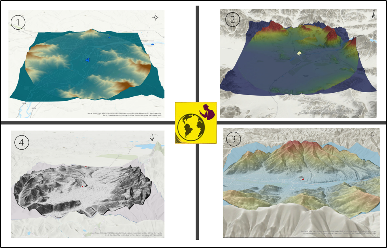
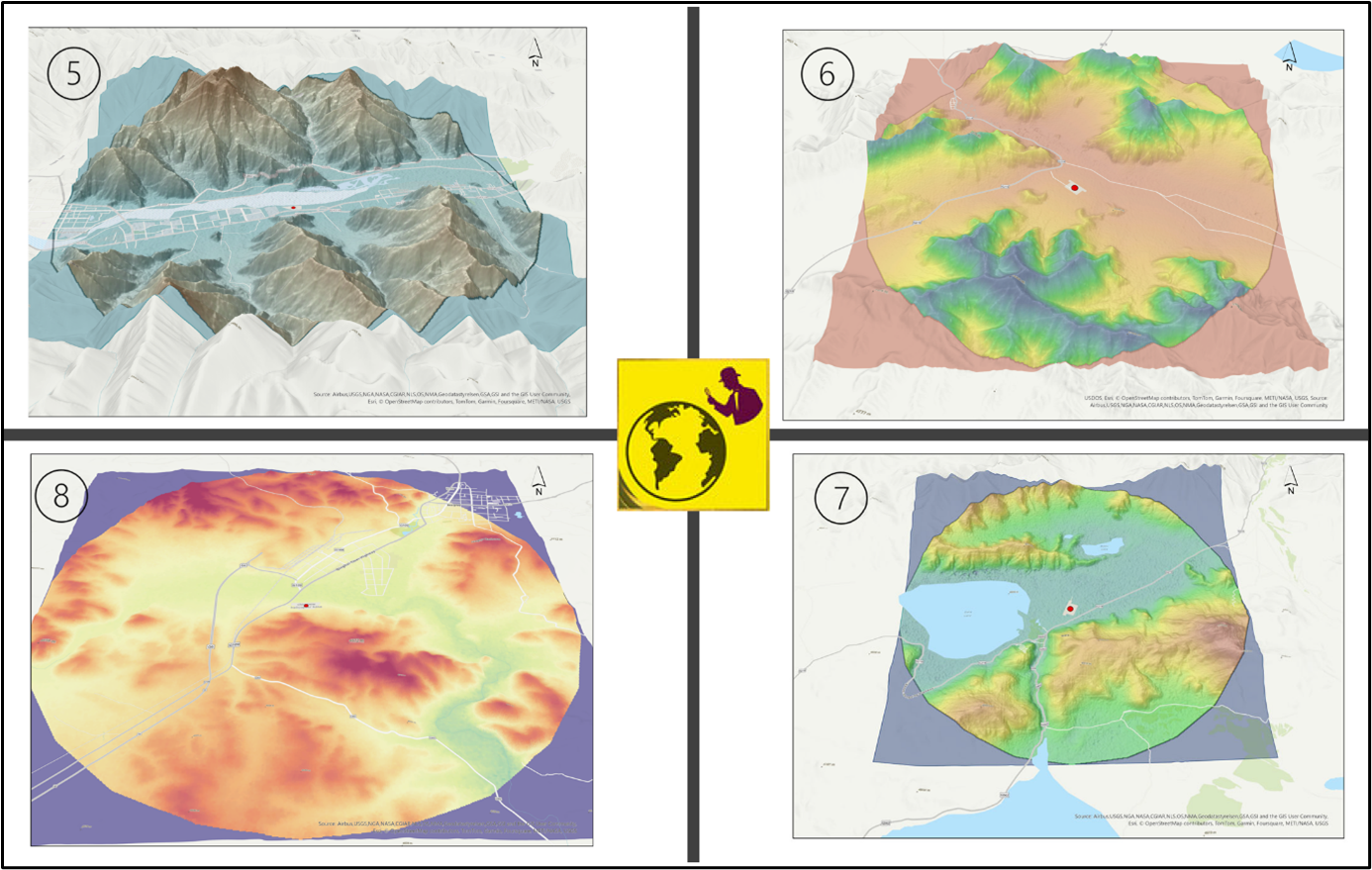
The two images show the 3D view of 8 sites from over 100 helipads and several regional heliports. The goal is to visualise the topography of these heliports, helipads, and their surroundings. Each image has numbers from 1 to 8 indicating the sites. The centre of each image shows the location of a site. Many of these sites are protected by mountains, near water bodies, and connected to highways. These locations were carefully selected for operational, logistical, and strategic purposes. This visualisation helps us understand the patterns in which these sites are established. By looking at a 10 km radius from the centre, we can see both the local topography and the strategic importance of each site.
Parting shot
The heliports and helipads at critical locations within the TAR are invaluable assets to the region's air infrastructure. These facilities are strategically established to support transporting personnel, supplies, and other necessities for PLA ground forces. Their locations are carefully chosen to leverage natural topographical protection and ensure they remain off the direct line of access from different regions.
Designed for self-sufficiency, these heliports are equipped with essential resources such as food, energy, and water. Additionally, they feature comprehensive facilities for soldiers, including residential buildings, sports facilities, and recreational infrastructures. This thoughtful planning underscores the long-term strategic importance of these heliports.
Despite their crucial role, the pace of construction and expansion for these heliports has slowed in recent years. While initial structures were established swiftly, further development has lagged compared to other regional air bases and infrastructure projects. This slowdown is likely due to the challenges of operating rotary infrastructure at higher altitudes. Meanwhile, the length of certain helistrips has been increased, and turning pads have been added at the ends. This indicates that the strips can now likely accommodate certain categories of UAVs capable of landing within a strip distance of 700-1000 meters.
In conclusion, these heliports' strategic placement and robust design ensure they remain a cornerstone of the region's military logistics and infrastructure, poised to support ongoing and future operations in the Tibet Autonomous Region.
In our research, we found several interesting military features around these helipads. We will discuss these in future editions of our newsletter. Stay tuned by subscribing.
The author thanks Lt Gen [Dr] Prakash Menon, PVSM, AVSM, VSM [Retd] and Air Marshal TD Joseph [Retd] for giving constant mentorship, as well as the two reviewers.
For regular updates on our geospatial research, stay tuned to https://takshashila.org.in/geospatial-research.
Disclaimer: Please be aware that the information and opinions provided in this newsletter are intended for informational purposes only. We advise readers to exercise their judgement and consider multiple sources of information before drawing any conclusions or making decisions based on the content presented in this newsletter.


Great work @Dr Nithiyanandam! The analysis is focused on TAR and Xinjiang which are in the direct control of China, but should we also consider other strategic locations such as Nepal's Pokhara Airport. https://swarajyamag.com/world/why-india-should-be-concerned-over-chinese-built-airport-at-nepals-pokhara-becoming-a-white-elephant-and-a-chinese-outpost#:~:text=space%20from%20Pokhara.-,If%20Pokhara%20turns%20into%20a%20Chinese%20outpost%20where%20its%20fighter,even%20beyond%2C%20will%20be%20vulnerable.