
#15 The Strait of Hormuz and the New Logic of Chokepoint Control
The Cartography of Maritime Control

In this edition, we’re looking at the world’s most critical maritime chokepoint: the Strait of Hormuz.
For years, people viewed it as merely a bridge for oil and gas. Either open or shut. Nothing in between.
The 2026 Hormuz crisis reveals that chokepoint control is no longer a binary (open/closed) but a layered spatial contest spanning seabed topology, island sovereignty, electronic warfare, and visibility asymmetry.
So where do we start? Let’s explore the backstory of the 2026 crisis, the strait’s history, its challenging geography, the geospatial challenges of monitoring vessels and movements, and a concise chronicle of major developments in the strait.
1. The Backstory
Before February 2026, every single day, roughly 20 million barrels of oil and petroleum products moved through the Strait of Hormuz. That one corridor accounted for more than a quarter of all seaborne oil traded globally and about a fifth of everything the world consumed. The numbers for gas were just as staggering: over 112 billion cubic meters of liquefied natural gas passed through each year, mostly heading to China, India, Japan, and South Korea. One in five LNG tankers in the world passed through this stretch of water.
When it comes to India’s dependence, about 45 to 50 per cent of India's crude oil imports used to go through the Strait of Hormuz, and Liquefied Natural Gas (LNG) dependence was just as dire, with 52 per cent of it coming through the single route.
Then the West Asian war began.
Regional military strikes triggered a chain of retaliatory actions. Mines were deployed. Blockades were enforced. And the waterway that had hummed with traffic for decades went almost completely silent.
Average daily ship transits collapsed, from 129 ships a day in late February to just six by late March. In just one month, the waterway experienced a 95% collapse. It represented the largest recorded disruption to maritime oil flows through a single chokepoint in the modern era.
For readers new to the term “maritime chokepoint”, the next few lines are for you.
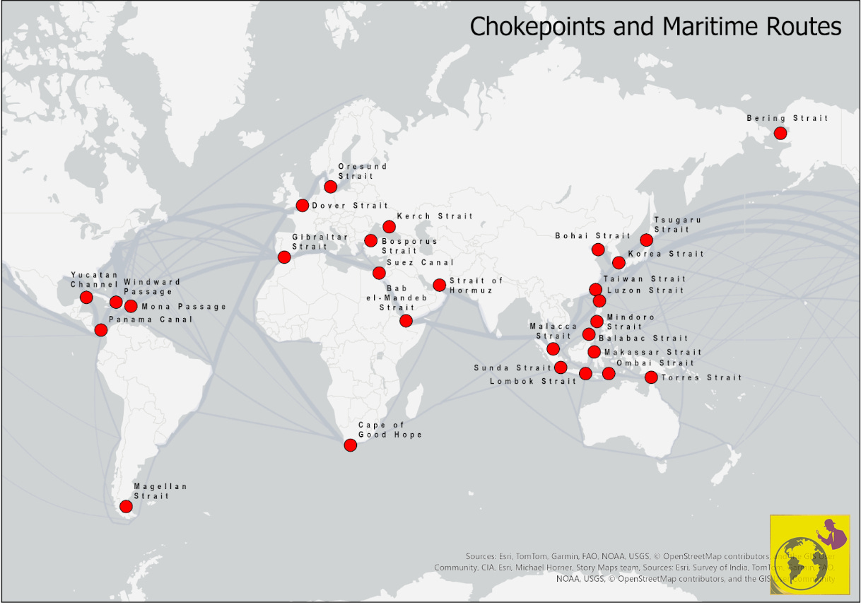
A maritime chokepoint is a narrow stretch of water where geography forces ships into a single, unavoidable corridor like traffic merging into one lane on a motorway. Whoever controls those banks controls what passes through them. When it closes, back routes are longer or rarely available.
The world’s first instinct after the Iran blockade, naturally, was to look for a way around the Strait of Hormuz. That instinct encountered a significant obstacle.
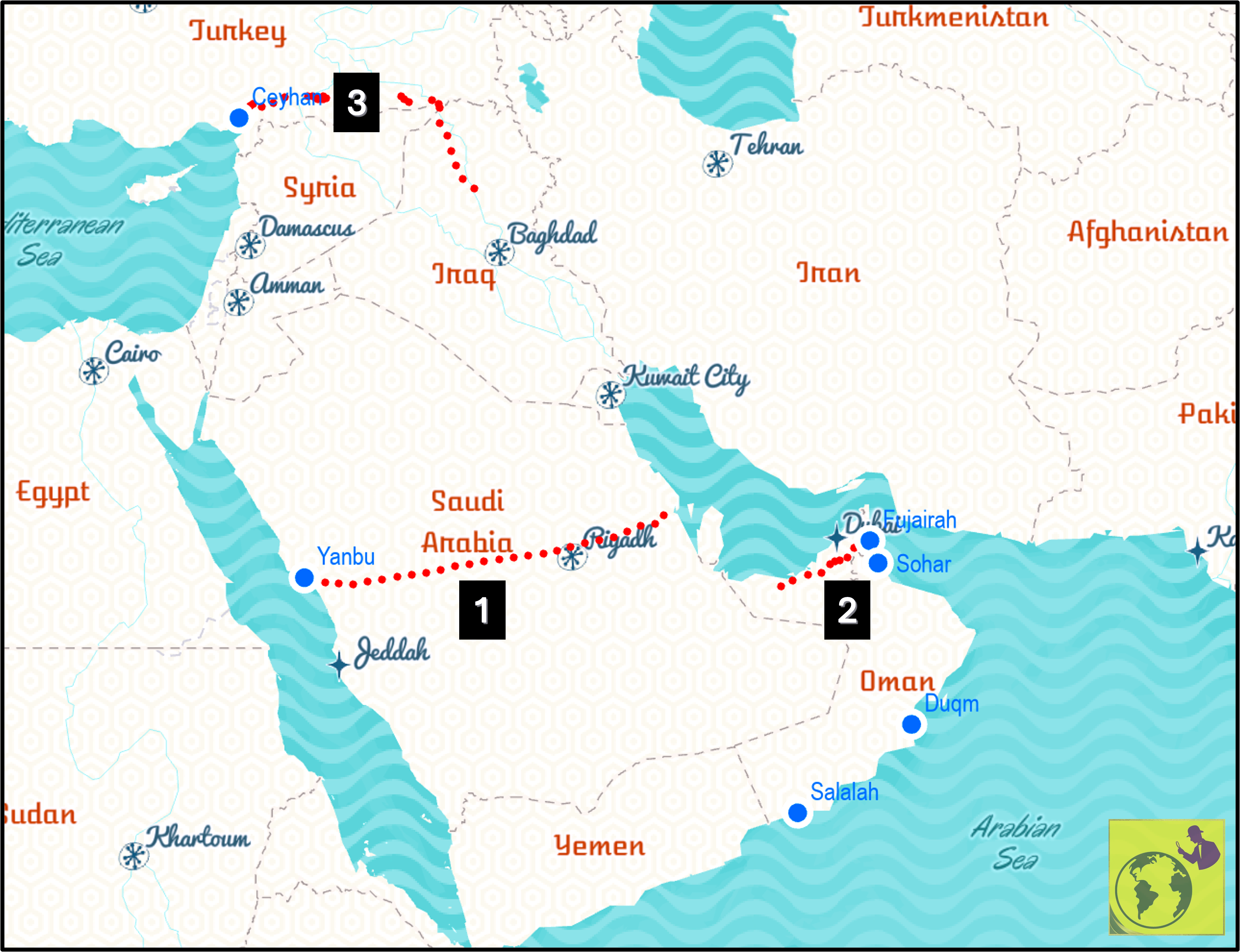
All the alternative bypass pipelines combined can move perhaps 3.5 to 5.5 million barrels a day. Saudi Arabia’s East-West pipeline and the Abu Dhabi pipeline, also known as the UAE's Habshan-Fujairah route, are useful but nowhere near enough to replace 20 million barrels.
And for LNG? There are no alternatives. Unlike crude oil, which can be moved by pipeline, LNG requires specialised cryogenic tankers and liquefaction/regasification terminals that cannot be replicated on land routes between the Gulf and Asia. Every cubic metre must therefore travel by sea.
What followed was not just an energy crisis. The disruption quickly cascaded into insurance, freight, and port operations.
Over 20,000 seafarers found themselves stranded in a high-stakes standoff nobody had planned for. The shipping lane became economically closed long before anyone formally declared it so.
The 2026 crisis was new in its scale and speed. The logic behind it was not. The Strait of Hormuz has been a contested chokepoint for over four thousand years, and that history shapes every decision made there today.
To understand what happened in 2026, it is critical to take into account the strait’s 4,000-year history of control and disruption.
2. The Historical Context
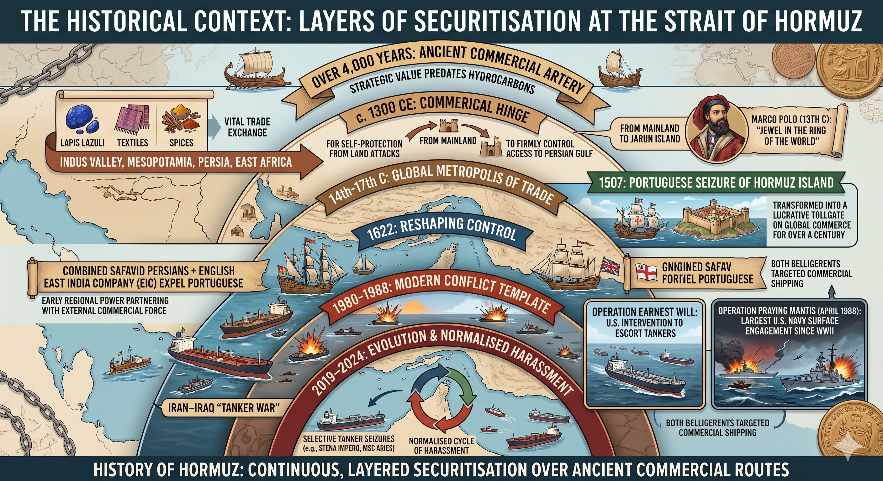
To understand the modern securitisation of the strait, we must recognise that its strategic value long predates the discovery of hydrocarbons.
For millennia, the broader Gulf corridor has functioned as a vital maritime trade artery, facilitating the exchange of lapis lazuli, textiles, and spices between the Indus Valley, Mesopotamia, Persia, and East Africa.
It has always been a commercial hinge. Around 1300 CE, the local polity shifted its centre of power to Jarun Island to strengthen maritime control and defend against land attacks.
In the 13th century, Venetian explorer Marco Polo passed through, famously describing Hormuz as the “jewel in the ring of the world.”
From the 14th to the 17th centuries, it was a global metropolis of trade. This immense wealth attracted external maritime empires. In 1507, the Portuguese Empire seized Hormuz Island, transforming the strait into a lucrative tollgate on global commerce for over a century.
It wasn’t until 1622 that a combined force of Safavid Persians and the English East India Company expelled the Portuguese, an early example of a regional power partnering with an external commercial force to reshape maritime control.
The Tanker War during the Iran–Iraq War (1980–1988) established the modern template for conflict in the Strait of Hormuz. Both belligerents targeted commercial shipping, prompting U.S. intervention under Operation Earnest Will to escort tankers. This effort culminated in Operation Praying Mantis (April 1988), the largest U.S. Navy surface engagement since World War II.
From 2019 to 2024, this conflict evolved into a normalised cycle of harassment and selective tanker seizures (such as the Stena Impero and MSC Aries).
The history of Hormuz is one of continuous, layered securitisation of ancient commercial routes.
While carrying a rich history, its geography also plays a crucial role.
3. The Geography
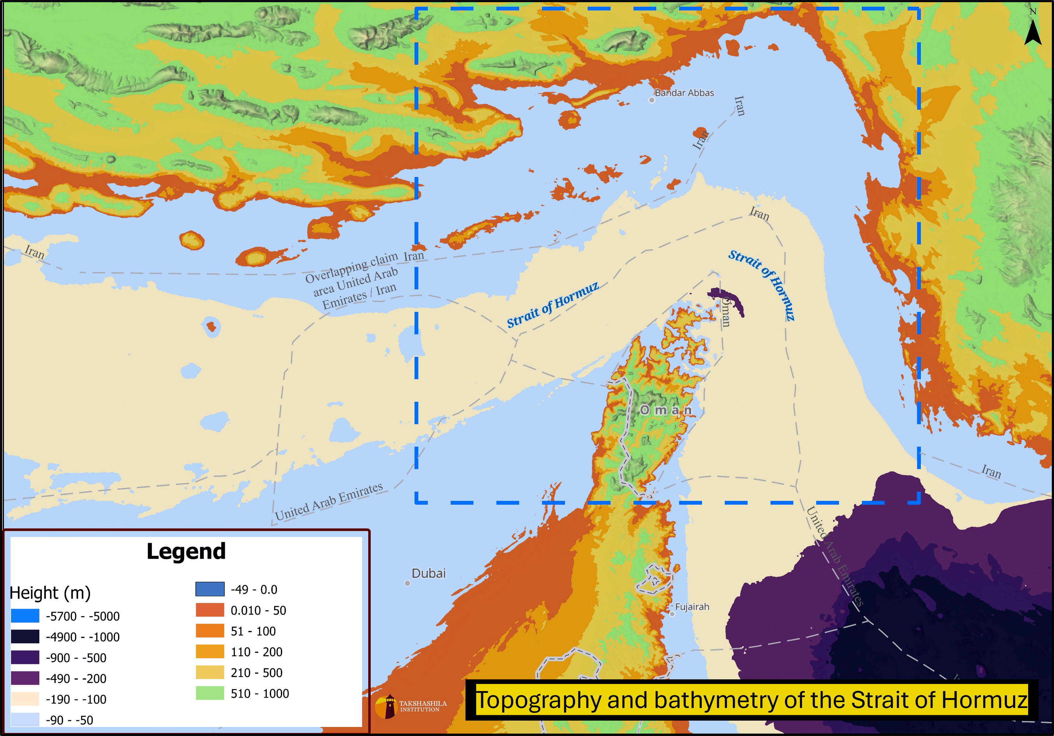
The physical geography of the strait – its tectonic origins, shallow Iranian shelf, and deep Omani channel – is not incidental to this history. It is what makes the strait both irreplaceable and indefensible.
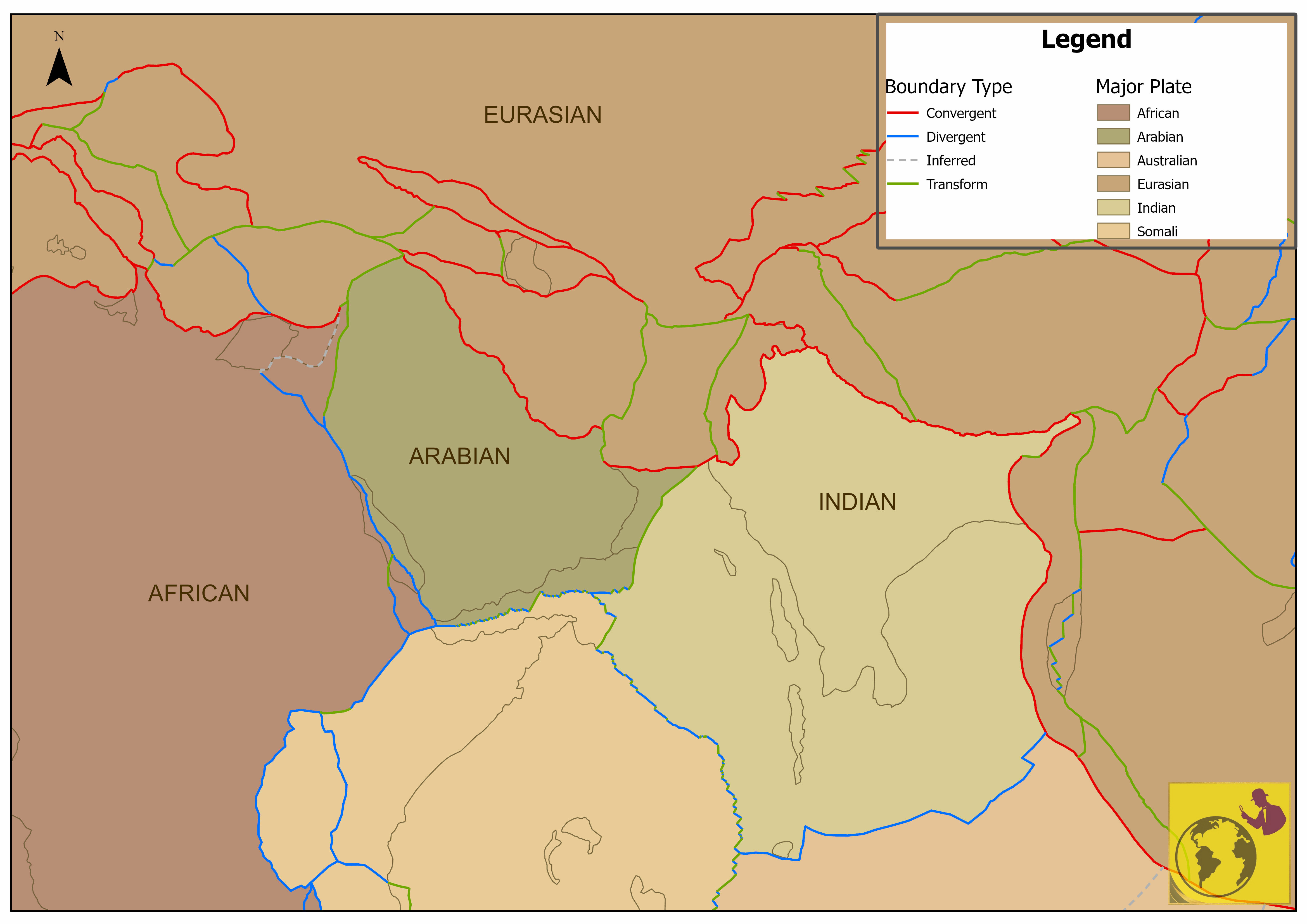
Approximately 35 million years ago, the Arabian Plate began its northward convergence with the Eurasian Plate. The Arabian Plate converged with the Eurasian Plate, driving folding, uplift, and basin formation in the region.
This tectonic collision created the shallow, sediment-rich Persian Gulf floor, and it is that shallowness, particularly on the Iranian side, that defines the modern tactical geography of the strait.
During the Last Glacial Maximum (~20,000 years ago), sea levels were 100 metres lower, and the Persian Gulf floor was largely dry land.
The tectonic reality today is that the strait is geologically narrowing over geological timescales.
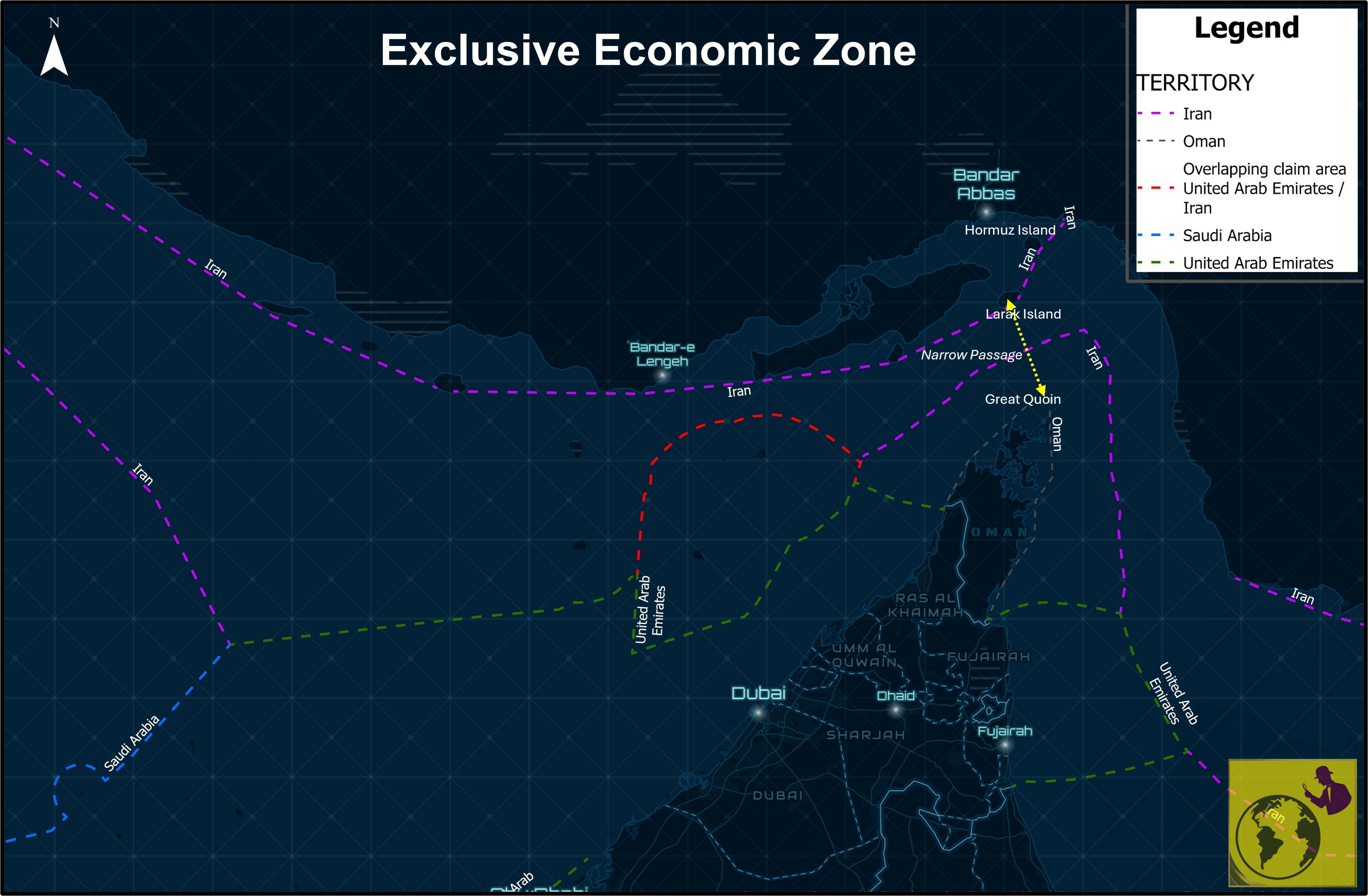
When it comes to the dimensions of the strait, it stretches about 167 km in length and narrows to roughly 33 km at its tightest point. But the navigable space available to vessels is far narrower and more constrained.
In 1968, the International Maritime Organization introduced a Traffic Separation Scheme (TSS), with two shipping lanes, each about 2 miles wide, separated by a 2-mile buffer. The overlap of Iranian and Omani territorial waters in some areas narrows the passage to about 21 nautical miles between Great Quoin and Larak Island, causing these lanes to run very close to the coasts.
Ships do not move freely between lanes in the Strait of Hormuz, because routing depends on bathymetry, the traffic separation scheme, vessel draught, and the security situation at the time.
The deepest waters lie off Oman’s Musandam Peninsula, while the Iranian side is shallower in parts, so the eastern approaches are less suitable for huge, deep-draught tankers.
In practice, that means VLCCs usually prefer the deeper Omani corridor, especially when tension rises or when vessels want to stay clear of the more exposed waters near Larak and the Iranian coast.
For India, the situation matters because its crude imports rely heavily on VLCC-class carriers, leaving them with few practical alternatives through the strait and making their route both essential and vulnerable.
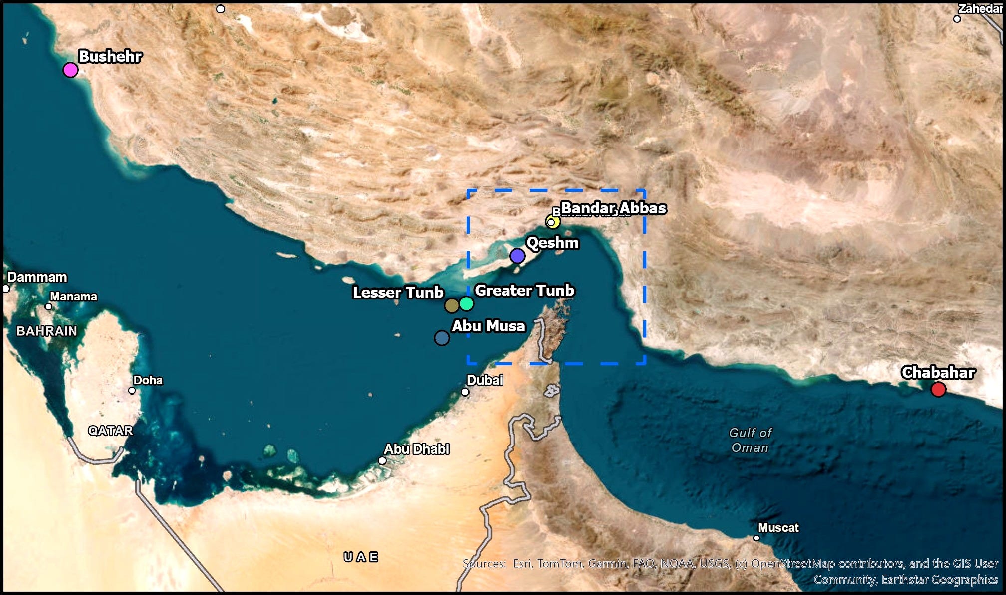
When it comes to control over islands in the conflict zone, Iran controls seven of the eight major strategic islands that dot the strait. Iran and the UAE hotly contest three of these islands: Abu Musa, Greater Tunb, and Lesser Tunb. Iran maintains a military presence on all three and operates major naval bases at Bandar Abbas, Bushehr, Chabahar, and Qeshm.
The U.S. Defence Intelligence Agency estimates that Iran possesses over 5,000 naval mines capable of rapid deployment, posing a massive area-denial threat in these narrow waters. The hydrographic realities of monsoon-linked current patterns, dust, haze, and variable visibility almost guarantee maritime miscalculation.
The shallow Iranian shelf that bathymetric analysis shows is a tactical vulnerability and became just that: a place where mine-laying was possible and VLCC routing was forced. Phase 1's 95% traffic collapse was a direct consequence of geography, not just political will. Let’s move on to what’s happening now.
4. What's been going on in the last 60+ days?
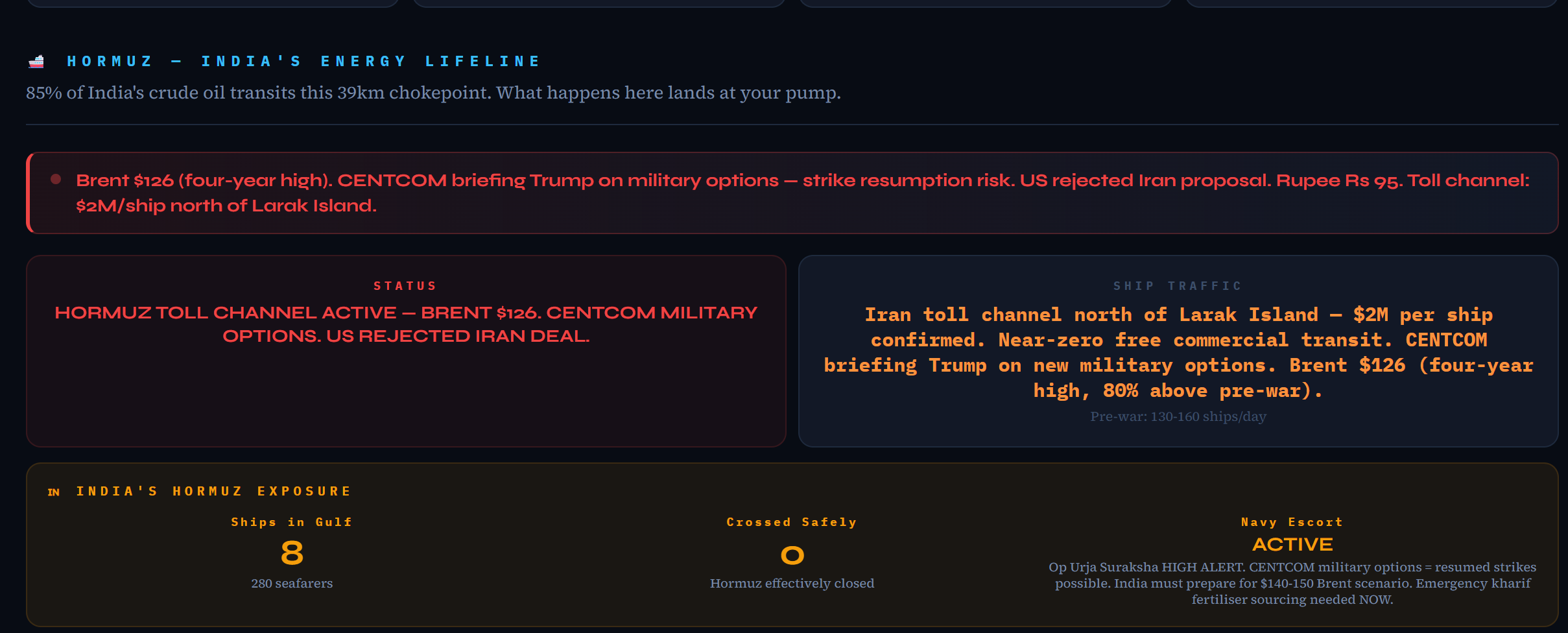
Below is the 61-day chronicle, extracted from my dashboard: the India Risk Assessment Dashboard, which has a dedicated section to track the Strait of Hormuz. The information curated in the dashboard is from 50+ reputed international sources and verified manually.
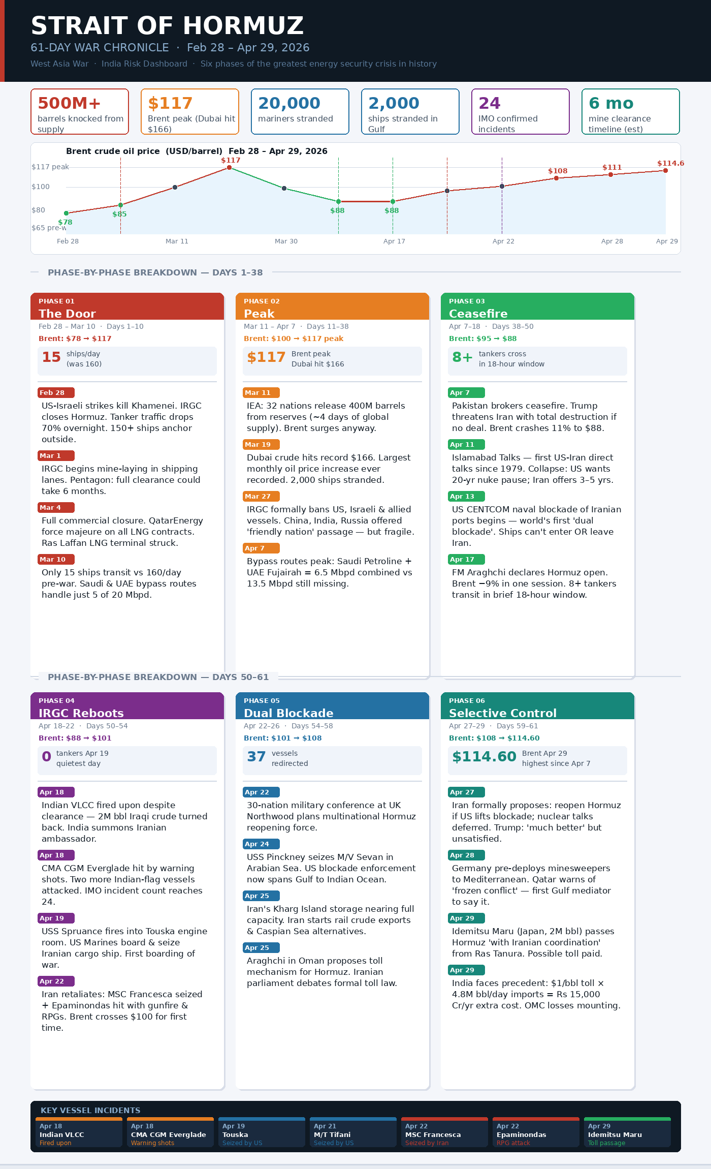
In my inference,
Iran did not try to “close” the Strait of Hormuz in the traditional sense. It tried to change how the strait works.
This conflict wasn’t a straight escalation. It appears to have followed a controlled-escalation pattern.
In the early phase, traffic collapsed not because of constant naval battles but because of risk. Mines, patrol zones, and uncertainty made the route too dangerous. Insurance costs surged. Ships stayed away.
Geography played a key role. The shallow Iranian side became a zone for mines and disruption.
The deeper Omani channel became the only viable path for large vessels, and therefore the most exposed one.
Iran didn’t need to control the entire strait. It only needed to make that narrow, unavoidable corridor unpredictable.
The brief reopening on April 17 is the turning point. It indicated that Iran could open and shut the strait quickly and on its own terms. This suggests selective control rather than a full closure.
By the final phase, the situation became clearer. Some ships were allowed through with coordination. Others were blocked or attacked. This is not closure. It is selective access.
There’s a historical echo here. In the past, powers didn’t always block trade routes; they controlled and taxed them. What we are seeing now is a modern version of that idea.
The result is something new. A chokepoint is controlled in layers, with both sides able to disrupt it, but neither side is fully in charge.
For countries like India, the risk is deeper than just dependence on oil imports.
It is physical. Large tankers have no choice but to pass through the deeper channel.
That places them directly within range of shore-based threats.
There is no alternate route for these vessels. Which means the real question is no longer whether the strait is open or closed. It is who decides which ship gets through.
It's interesting to note that the bigger vessels are struggling to pass. Class B vessels (a separate commercial cargo/special purpose classification) carrying the Indian and Sri Lankan flags were able to come and go freely by hugging the Omani coast closely. While not much information is available about the ownership of these vessels, their movement patterns suggest they may be used for informal or illicit trade.
5. Seeing Through the Noise: Intelligence and Visibility Challenges
To understand what happened in the strait, we must first grasp the limits of our visibility and recognise that these limitations were, in themselves, a weapon.
With the high-end satellites and other modern technological developments, it appears that tracking vessels and even boats is basic. But smaller countries still need to leverage cutting-edge solutions in the maritime domain. On top of this challenge, the geopolitical situation has partially made the tracking blind.
Tracking is not simple; check out my blog on this topic, “Why Tracking Ships at Sea Is Not as Easy as It Seems.”
While this war has created limited access to open-source intelligence and commercial high-resolution satellite imagery, it has also restricted the availability of other critical information. Even groups like Bellingcat, which build open-source tools to monitor events such as infrastructure damage, face constraints without depending on high-resolution imagery.
Vessel tracking largely depends on the signal it transmits, primarily for navigation and collision avoidance. It is called AIS (Automatic Identification System).
When those signals are disrupted or switched off, visibility drops sharply.
Here are the two challenges AIS-based observation brought out:
First is selective visibility. AIS transmission can be switched off or manipulated in practice, even though it is central to safe navigation and collision avoidance. Vessels can choose when to be seen. That creates “dark vessels”.
Traditionally, that term points to military ships. But in this crisis, commercial vessels also went dark. Why? Some switched off signals to avoid being targeted by Iran. Others, moving with Iran’s clearance, stayed hidden until they passed through the strait to avoid misidentification or false flag risks.
The second is GNSS spoofing. Since the first week of March, spoofing has hit over 1000 vessels across the Gulf.
The time-lapse video of recorded spoofing incidents highlighted as “RED” around the conflict zone from March 1 to April 14 was extracted from Flightradar24.com.
You see something strange. There is almost no red over the waters of the Persian Gulf.
Why? This chokepoint data is based on air traffic. Given the limited flights over the region, the dataset appears to be empty over the Gulf. But that doesn’t rule out spoofing. When we tracked ships, the positions were clearly skewed.
Some of the ships looked displaced. In a few instances they were falsely represented on land. That’s a strong signal. Spoofing also appears to have been widespread across the wider conflict zone.
What does spoofing do?
It feeds false signals to a ship, making it think it’s somewhere else, moving differently, or even at a different time.
In open seas, that’s risky. In a narrow strait, it’s dangerous.
A drift of just 2 miles can materially increase the risk of grounding, collision, or misinterpretation.
Furthermore, larger vessels are not the only ones affected; small boats and traffic also feel the impact when they use GNSS as a navigation aid. And such events happened at scale.
At one point, zero tankers crossed the strait on a single day. Around 1600 vessels waited, looped, or vanished from tracking systems because they remained stuck in one place for a longer time.
The result? It is a chokepoint with few ships moving due to a partial blockade, and the situation is unclear.
Control of a maritime chokepoint in 2026 encompasses three overlapping domains: physical passage, positional intelligence, and electronic visibility – each of which Iran and the US contested simultaneously. The region has seen a positive trend over the last two weeks with fewer spoofing incidents.
On one side, authorities have restricted access to high-resolution satellite imagery, limiting what the world and even adversaries can see in near real time.
But that does not mean visibility is gone. It has shifted.
There are growing indications that Iran still has access to space-based intelligence through alternative channels. Reports suggest the use of Chinese commercial and dual-use satellite imagery, as well as navigation support systems, to monitor and potentially target activity in the region.
At the same time, China’s expanding satellite network and private geospatial firms continue to generate detailed imagery and analysis over the conflict zone, even as some Western providers scale back access.
The result is a fragmented picture. Visibility is no longer uniform or shared. Some actors see less. Others may still see enough.
And in a contested space like the Strait of Hormuz, that imbalance matters just as much as physical control.
6. Parting Shot
In the early days of the West Asia war, the focus was on strikes and counterstrikes.
But as the conflict evolved, the centre of gravity shifted.
The narrow passage. The Strait of Hormuz is not just a route. It is a global lifeline.
Any disruption here ripples instantly across economies that depend on the steady flow of oil, gas, and their downstream products.
A blockade was always part of the playbook. US-led assessments, backed by years of research and declassified analysis, anticipated that Iran could attempt to disrupt the strait. The assumption, however, was that such efforts would remain contained and ultimately prove ineffective against a superior naval force.
That assumption was only partially validated. Iran's layered denial did not require defeating US naval superiority. It only required making passage sufficiently uncertain. What was underestimated was the method.
Not a large-scale naval confrontation, but a layered approach: drones, small boats, mines, and signal disruption. These tools do not need to overpower a navy. They only need to create uncertainty. And uncertainty is enough to slow, divert, or halt global shipping.
The shallow (60-100 m) Iranian shelf, whose bathymetric analysis shows it to be unsuitable for VLCC manoeuvres, became a mine-laying corridor. Iran’s island holdings can be read as a dispersed support architecture that complements shore-based capabilities.
What we are seeing is not a traditional blockade. It is a hybrid control model – physical, digital, and psychological.
The full picture is still incomplete. Much of what happened on the water remains obscured by limited access to high-resolution satellite imagery.
When that data becomes available, the map will likely look very different.
Key indicators to watch?
The story does not end here. A few measurable signals on the ground will shape the next phase.
1. Coordinated ship passages
Watch if countries like Japan, India, or South Korea begin formally coordinating with Iran for safe transit. That would signal a shift toward managed access.2. Minesweeper deployment
If Germany and others move forward with mine-clearing operations, it points to a possible reopening timeline in weeks.3. Storage pressure at Kharg Island
As oil storage fills up, Iran will face pressure to allow more ships through. Rising tanker loading activity will be a key sign.4. Ships turning AIS back on
If more vessels near the Strait of Hormuz start transmitting again, it suggests growing confidence and a more stable flow.
For more up-to-date information on West Asia, check here: https://nithiyageo.github.io/india-risk-dashboard/
Additional resources for reading:
Possible impacts to India: 1. Geopolitics of LPG Supply in India; 2. Geopolitics of Fertiliser Supply in India
For more updates on the West Asia war, check out Takshashila Institution's West Asia War – Weekly Dossier
Disclaimer: Please be aware that this newsletter provides information and opinions intended for informational purposes only. We advise readers to exercise their judgement and consider multiple sources of information before drawing any conclusions or making decisions based on the content presented in this newsletter.
Declaration: This article has been proofread using AI tools.
For other newsletters from Takshashila Institution, refer to https://takshashila.org.in/newsletters/
Course Alert: Takshashila Institution’s Postgraduate Programme (PGP) in Public Policy. 48 weeks. Starts 20 June 2026. The early bird closes tomorrow.
Apply now: http://school.takshashila.org.in/pgp