#9 Unlocking Tibet: In-Depth Mapping of Transport Infrastructure Through Geo-Spatial Analysis
TL;DR
Geospatial maps help understand the connections between transportation networks. The study used advanced geospatial analysis, using data from various sources, including open-source information.
The study mapped Tibet's comprehensive transportation network, which integrates roads, railways, and air infrastructure. This network has the potential to transform the region economically, socially, and militarily, thereby influencing regional stability and significance.
Tibet's transport infrastructure has grown massively since 1959, with a 16-fold increase in road networks, the introduction of strategic rail lines, and new air infrastructures bolstering China's logistical capabilities and regional connectivity.
Why is this article a must-read for you?
Suppose you follow Chinese infrastructure development in Tibet. In that case, you've likely heard about their impressive road systems, engineering feats in high-speed rail across challenging terrains, and rapidly expanding air infrastructure. This article uses geospatial tools to compile and analyse the information generated through various sources, offering a comprehensive visual view of Tibet's transportation network. By exploring these maps, you'll gain a deeper understanding of the vast infrastructure, its potential strategic implications for neighbouring countries, and insights into potential regional growth and plans.
The Backstory
China's ongoing efforts to overcome the significant barriers that impede movement between the Tibet Autonomous Region (TAR) and other Chinese provinces are part of larger strategic goals. These barriers, including surging rivers, rugged mountain terrain, fragile ecosystems, and extreme climatic conditions, have been a part of Tibet's landscape for centuries. The year 1959 marked a significant shift when the transportation of supplies from provinces like Yunnan, Sichuan, and Qinghai heavily relied on humans and livestock. Since then, Tibet's transport infrastructure has seen substantial growth. The total road network in TAR, which was 7,300 km in 1959, expanded to 120,000 km by 2021, a growth of 1543%. This development includes major highways that connect cities, towns, and rural areas within TAR. The integration of Tibet into the Belt and Road Initiative (BRI) in 2016, a global infrastructure development strategy, has further accelerated this infrastructure growth, profoundly transforming TAR's social and economic landscape.
Despite its sparsely populated mountainous terrain, constructing rail lines in Tibet has been a strategic imperative for China. The inauguration of Tibet’s first rail line, the Qinghai-Tibet Railway, in 2006 was a significant milestone. This strategic vision is evident in that by 2020, Tibet will have only about 800 km of railway, a length comparable to that of Shanghai, despite Tibet being approximately 200 times larger in land area. However, this scenario is beginning to change. In 2021, China launched Tibet’s first high-speed rail line, connecting the regional capital Lhasa with Nyingchi. This line significantly enhances the capability to transport civilians swiftly, as well as PLA troops and equipment, across the eastern part of Tibet, thereby bolstering China's logistical capabilities. The implications of these developments are underscored by notable railroads such as Qinghai-Tibet (2000 km) and Sichuan-Tibet Railway, which connects Tibet externally; meanwhile, Lhasa-Shigatse (253 km) and Lhasa-Nyingchi (435 km) are the major rail projects that network internally within Tibet, underscoring the importance of Tibet's transport infrastructure.
As per literature, in recent years, air infrastructure has been significantly enhanced alongside the expansion of road and rail networks. Between 2017 and 2022, five airports were upgraded, and four new airports were established. Additionally, nine heliports became operational, further strengthening the region's air connectivity.

Why it is essential to understand transport infrastructure?
Studying the expansion of roads and other transportation networks in Tibet is essential for India. Firstly, enhanced connectivity in TAR can significantly impact regional trade dynamics, facilitating faster and more efficient movement of goods between China and South Asia. The development of robust transport infrastructure in Tibet enhances China's logistical capabilities, affecting the strategic balance in the region. Improved roads and railways mean quicker mobilisation of military assets, a critical consideration for India given the long-standing border disputes with China. Moreover, the environmental impacts of such infrastructure projects are significant. The fragile ecosystem of the Tibetan plateau, with its unique biodiversity and delicate balance, is susceptible to disturbances from large-scale construction activities. Understanding the environmental repercussions of these developments is vital for India, particularly concerning transboundary river systems originating in Tibet, which are lifelines for millions in South Asia. Lastly, the socio-economic transformation of Tibet, driven by improved infrastructure, can lead to demographic shifts and altered socio-political dynamics in the region, influencing Tibet's stability and potentially affecting neighbouring areas, including India. Therefore, a comprehensive study of the transportation network expansion in Tibet offers valuable insights into the broader implications for trade, security, environmental sustainability, and regional stability, all of which are paramount to India.
Road Infrastructure of Tibet Autonomous Region (TAR)
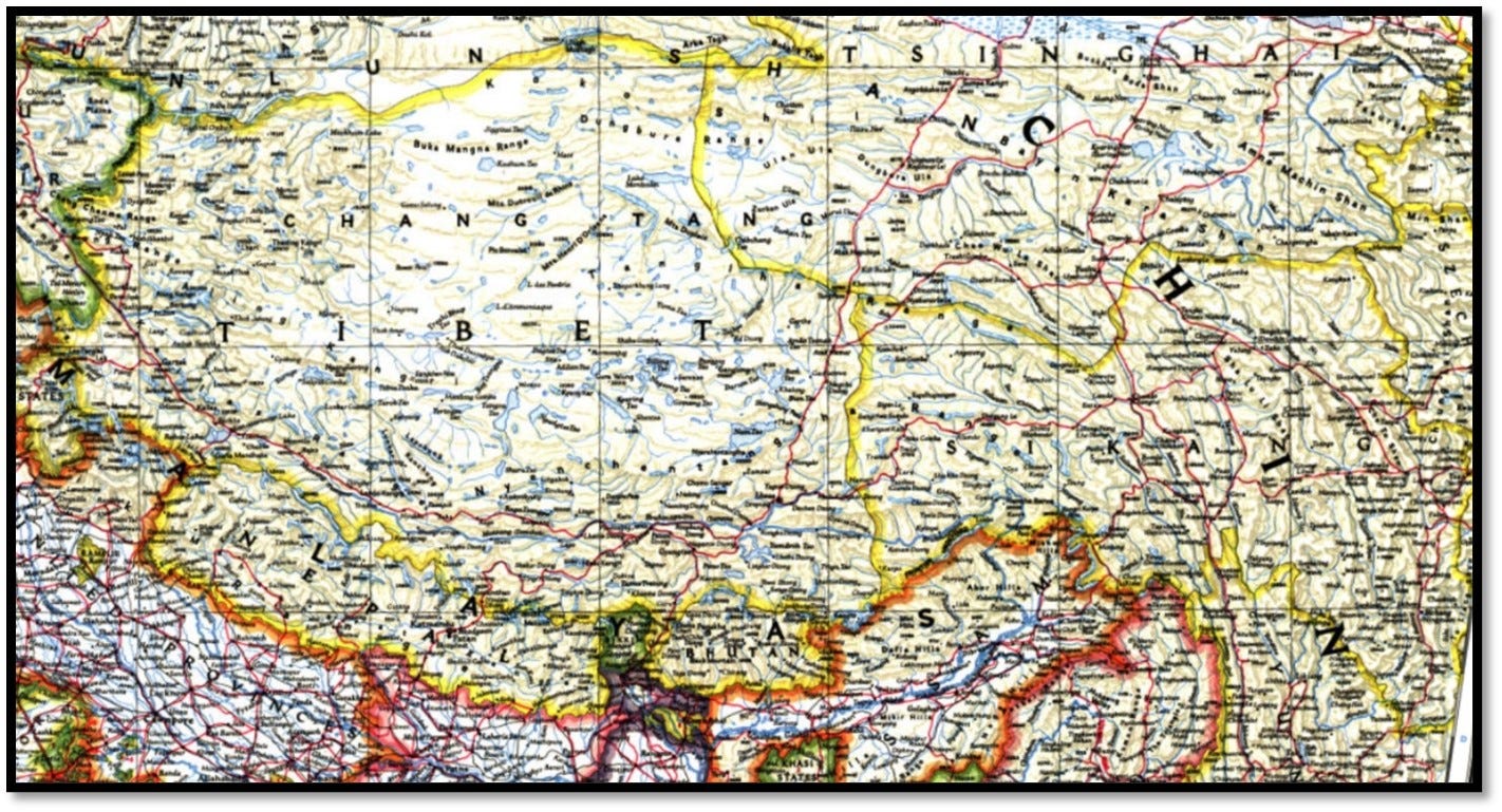
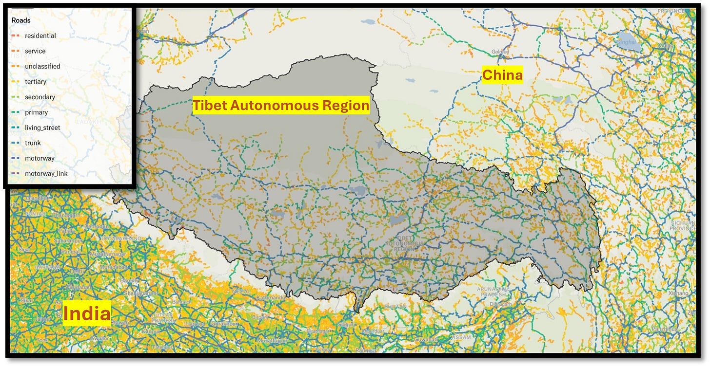
It is well-established that road infrastructure is crucial for various aspects, including a region's economic development. Figures 2 and 3 clearly illustrate that road networks have significantly expanded. When comparing maps from the pre-independence era to those of the present day, it is evident that the networks have rapidly extended both in length and breadth. This article will further explore whether this growth has primarily been in significant roads or if there has been a more extensive development of minor networks in the region.
Refer to Figure 2, which illustrates both minor and major roads. Specifically, the various categories of roads are detailed, with trunk and other significant roads depicted by blue lines. These trunk roads connect significant towns and critical areas along the border. Additionally, the figure shows minor roads, including tertiary and secondary roads extending across small villages and remote posts situated in regions closer to the border, remote villages in the valley, and rugged mountains.
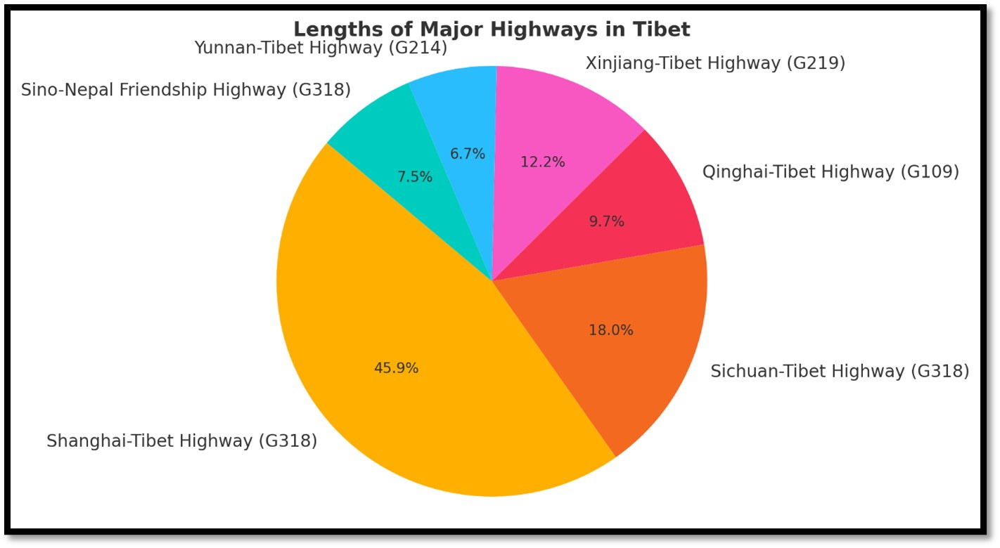
While minor roads are crucial for last-mile connectivity, developing major roads is essential for significant progress. Let's delve into this topic through the maps (Figure 4 & 5). The maps illustrate the network of substantial roads established over the past few years. The total length of highways in Tibet spans close to 18,000 km. Among these, the G318, the longest highway in Tibet, connects Shanghai to Tibet. Other significant highways include G109, G219, G214, and the Sino-Nepal Friendship Highway (also part of G318). The connectivity of these highways is detailed in Figure 4.
In addition to the major trunk roads, the trunk link roads play a crucial role in connecting the primary arteries with various regions. These can be considered secondary roads within the area, collectively spanning close to 14,000 kilometres across some of the most challenging terrains in the world. Different forms of minor roads extend further from these secondary roads, reaching villages and remote areas. Refer to Figure 5, which illustrates the significant and primary highway links. The types of roads are asphalt, concrete, gravel, paved, unpaved, and dirt.
Rail Network Infrastructure in Tibet

In late 1999, while other engineers were still figuring out how to make it work, Zhang Luxin, a renowned engineer with extensive experience in railway construction, proposed a new plan. His idea involved following the plateaus that stretch for hundreds of miles. Although the plateau is flat, it is situated at a high altitude and subjected to harsh weather and melting permafrost, making it a challenging route. Zhang argued that it is the best route because it has been used for other purposes. Since the 1970s, this path has been used for an oil pipeline and the route of the Qinghai-Tibet Highway. Many doubted Zhang's plan, believing workers could not survive the high altitudes. More than 644 kilometres of the railway would be built on permafrost, which remains frozen throughout the year. Some considered the technology for building on permafrost too new and risky. However, Zhang persuaded them that it was feasible. Officials approved the route from Golmud to Lhasa, and construction began. This project became one of the most challenging railway lines ever built, high up in the mountains. Today, we see numerous high-speed railways and long tunnels constructed with cutting-edge technology.
The Belt and Road Initiative (BRI) includes several projects in Tibet that are also aimed at enhancing connectivity between China, Nepal, and Bhutan. Central to this effort is the development of the Trans-Himalayan Multi-Dimensional Connectivity Network. This network includes infrastructure projects such as the railway extension towards the Nepalese border at Gyirong, which aims to connect with the planned Kathmandu-Kerung railway. These rail and road links are expected to facilitate trade and transit between Tibet and Nepal, promoting economic integration and regional cooperation. Additionally, there are discussions about extending road connectivity from Tibet to Bhutan, which would further enhance regional connectivity under the BRI framework. These projects are part of China's broader strategy to strengthen economic ties and enhance logistical links in South Asia through Tibet.
The Tibet railway network, notably the Qinghai-Tibet Railway and its extensions, is both a challenging and impressive feat due to several unique factors. The railway traverses some of the world's highest and most inhospitable terrains, with sections reaching over 5,000 metres, presenting significant engineering and human health challenges, such as altitude sickness and extreme weather conditions, including sub-zero temperatures and strong winds. Much of the railway is built on permafrost, requiring innovative engineering solutions to ensure stability, such as laying tracks on thick layers of rock and concrete to prevent the permafrost from melting and destabilising the tracks. Constructing the railway in a fragile ecosystem requires careful planning to minimise environmental impact. This includes building bridges over animal migration paths and using unique materials to reduce soil erosion. Transporting materials and machinery to such remote and high-altitude locations posed significant logistical challenges, and the workforce had to endure difficult living conditions. Ensuring a continuous supply of necessary materials was complex.
Despite these challenges, the Qinghai-Tibet Railway, completed in 2006, is a remarkable engineering achievement. It includes the Tanggula Pass, the world's highest railway pass at 5,072 metres, and the Fenghuoshan Tunnel, the highest railway tunnel in the world. Advanced technologies were employed to address the challenges of building on permafrost and high altitudes, such as cooling pipes and insulation layers to stabilise the ground and pressurised train cabins to ensure passenger comfort at high altitudes. The railway has significantly boosted the economy of Tibet, facilitating the transport of goods and people, improving access to remote areas, promoting tourism, and providing better connectivity for local populations. The extension of the railway network towards Nepal and potentially Bhutan demonstrates China's commitment to regional connectivity under the Belt and Road Initiative, aiming to enhance trade and economic integration between China and its South Asian neighbours.
Air Infrastructure of Tibet Autonomous Region

Air infrastructure is vital in Tibet, overcoming significant geographical and topographical challenges, including high altitudes, mountainous terrain, and harsh weather conditions that make ground transportation difficult. It provides a reliable alternative for moving people and goods efficiently, boosting tourism and facilitating trade. Strategically, air connectivity allows for the rapid deployment of troops and supplies, which is essential for border security. It also enhances accessibility to remote areas, ensuring the delivery of essential services and promoting cultural exchange and integration. Key airports like Lhasa Gonggar and investments from initiatives like the Belt and Road Initiative (BRI) are central to these efforts, highlighting air travel’s crucial role in Tibet’s economic and social development.
The air infrastructure in Tibet has significantly improved over the years. Several old airports have been renewed, and new airstrips are being constructed. Additionally, many shorter airstrips and heliports have been strengthened.
In our previous research, we covered some of these developments. However, in this edition, we have found that the infrastructure has grown even more. For instance, the number of airstrips has increased from 9 to 13 in the last two years. Existing literature on the topic identified nine airstrips till 2022. Meanwhile, our current study has identified 13. The number of functional and non-functional helipads identified through open-source intelligence is significantly higher than previous research in the public domain.
As stated in earlier research, most airports and airstrips in the Region serve dual purposes, catering to tourism and civilian movement within the country and acting as military bases for the PLA's Air Force. Although the capacity for military operations at these airstrips is unclear, Tibet has several functional civilian airports, with Lhasa Gonggar International Airport being the largest and most important. Lhasa Gonggar Airport has a significant capacity to handle 9 million passengers annually. The airport's Terminal 3, which opened in 2021, contributes significantly to this capacity with 21 additional boarding gates and extensive facilities designed to accommodate high passenger volumes. Other notable airports in Tibet include Nyingchi Mainling Airport, Shigatse Peace Airport, Ngari Gunsa Airport, and Qamdo Bangda Airport. These airports form a network facilitating domestic and limited international travel, primarily connecting to major Chinese cities and Kathmandu in Nepal.
Overall connectivity: transportation nexus

Integrating Tibet’s Road, air, and rail infrastructure creates a transformative nexus that significantly impacts tourism, economic activities, and military logistics. This comprehensive transportation network facilitates greater accessibility, enabling a surge in tourism by connecting remote areas with significant cities and international destinations. For instance, the Qinghai-Tibet Railway and newly expanded air routes have improved connectivity, boosted the number of tourists and contributed to the local economy.
Furthermore, the development of these infrastructures supports large-scale economic projects and civilian activities by enhancing the flow of goods and services, which is vital for Tibet's economic growth. The railways and highways, such as the Qinghai-Tibet and Sichuan-Tibet Highways, play a critical role in the movement of both civilian and military personnel, underscoring their importance.
Overall, the enhanced transportation infrastructure in Tibet fosters regional economic development and tourism and strengthens the military's logistical capabilities, contributing to the area's stability and significance.
Nexus between Transportation network and PLA presence

Figures 10 and 11 illustrate the strategic distribution and connectivity of major PLA bases in Tibet. Figure 12 depicts the locations of these bases across the region, while Figure 13 highlights the comprehensive network of road, railway, and air infrastructures connecting them. This map underscores how transport infrastructures are designed with dual purposes, serving both civilian needs and military operations.
Settlement infrastructure and road connectivity


Figure 12 shows the distribution of major cities, small and medium towns, and villages within the Tibetan region. Some of these settlements are close to the borders shared with India and Bhutan.
Figure 13 highlights the connectivity of these settlements to major roads. This visualisation specifically showcases the significant roads, indicating a well-established network. It is important to note that this network includes paved and unpaved minor roads, serving multiple purposes. These minor roads provide crucial last-mile connectivity, linking remote posts and villages to the broader transportation system.
The complexity of the terrain
Tibet's terrain is complex, with vast plateaus, towering mountain ranges, and dramatic altitude variations, posing challenges for infrastructure development. The 3D map of Tibet Autonomous Region and other vital prefectures follows:
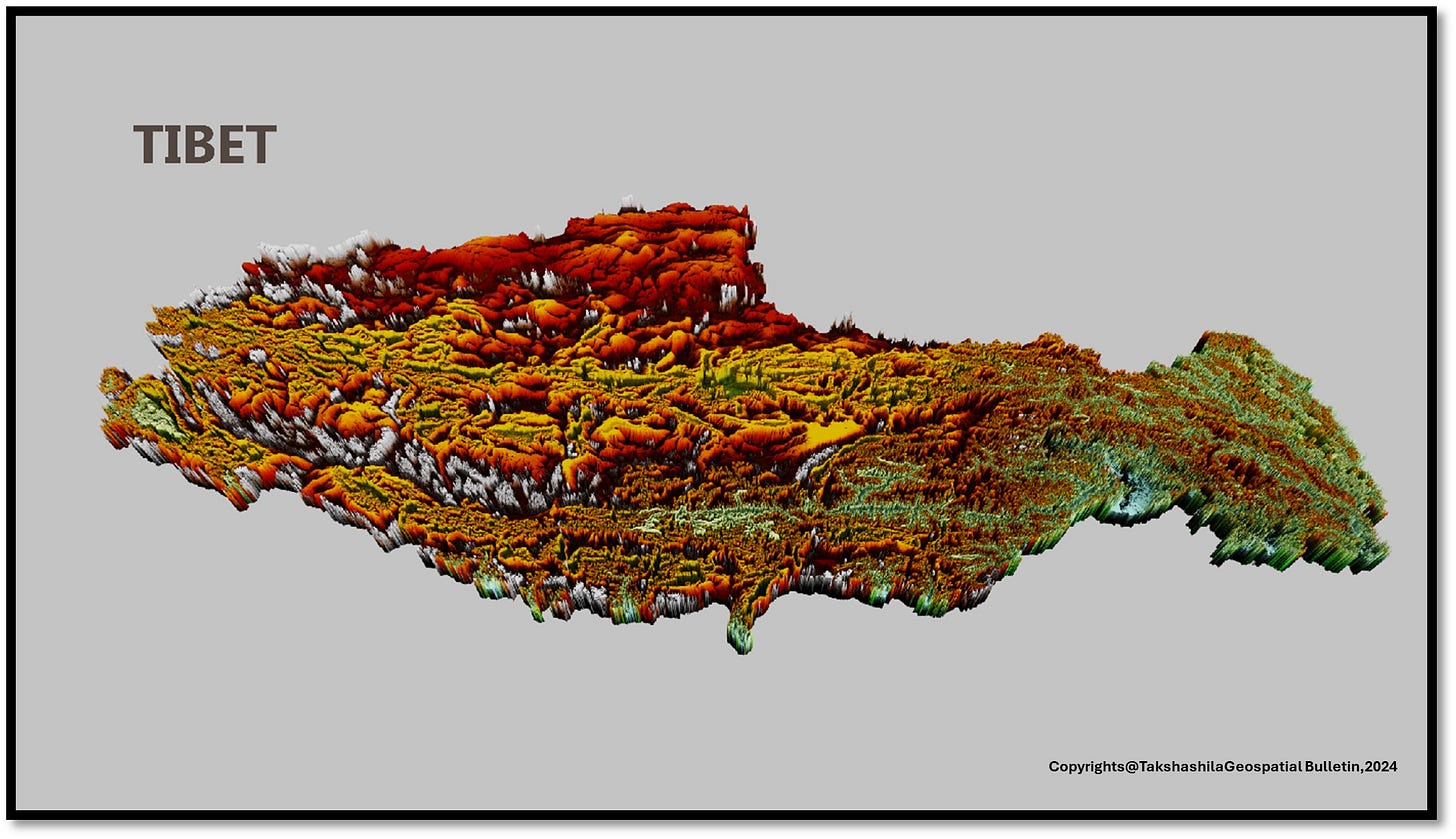
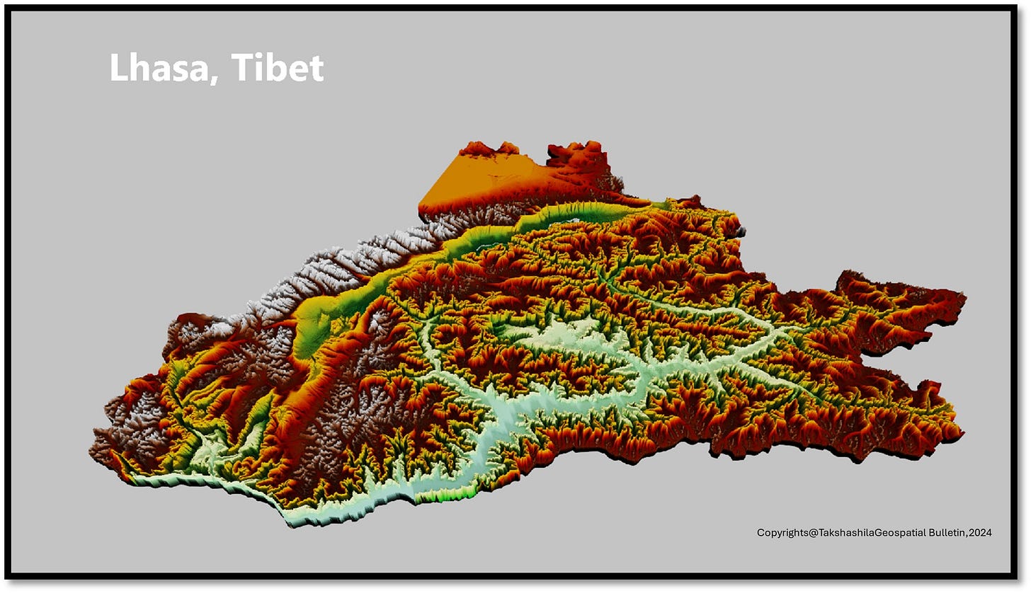
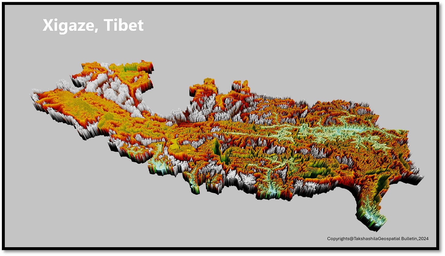
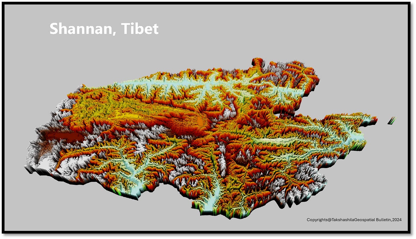
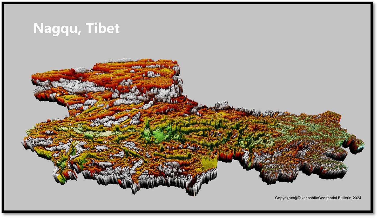
The maps (1414–18) show how challenging it is to find flat land for development in Tibet due to its rugged terrain. Few flat areas are suitable for construction, making land availability a significant challenge. Despite these obstacles, essential infrastructure projects, especially transportation, have been successfully established in the region. The images illustrate how even the most minor pieces of land are creatively used for various purposes, highlighting the region's resourcefulness in overcoming geographical constraints to develop essential infrastructure. This reflects the difficulties and achievements in adapting to Tibet's unique environment.
Tunnels and culverts in the complex terrain

In our study, we have mapped the locations of over 400 culverts and more than 600 spatial segments of tunnels in the region. The culverts are built primarily to allow water and debris passage over canals, rivers, streams, and ditches. On the other hand, the tunnels are designed specifically for road and railway systems, forming integral components of transportation networks. Tunnels and culverts are essential for ensuring the efficient use of transportation infrastructure under all weather conditions. Additionally, the tunnels reduce travel times and improve access to strategically important areas, offering economic or military advantages.
Culverts play a critical role in maintaining transportation routes' structural integrity and functionality by preventing water accumulation and erosion, thereby mitigating potential damage to the infrastructure. Meanwhile, tunnels facilitate seamless traffic flow through challenging terrains, such as mountains and hills, enhancing connectivity and accessibility. This improved connectivity supports economic activities by providing quicker routes for transporting goods and services. It enhances the mobility of military forces, ensuring rapid deployment and logistical support in critical areas. Integrating these infrastructural elements demonstrates a sophisticated approach to overcoming geographical challenges and optimising the transportation network for multifaceted benefits.
Parting shot
The insights shared in this edition aim to provide foundational spatial information about the transport infrastructure of the Tibet Autonomous Region, showcasing its readiness for economic expansion, resource utilisation, and military fortification compared to neighbouring areas. The focus has been mapping the various types of existing infrastructure and the inherent complexities of Tibet's unique and challenging terrain.
This analysis highlights the significant progress made in constructing roads, railways, and air links in one of the world's most challenging regions. The vast plateaus and towering mountain ranges necessitate specialised construction techniques and meticulous planning. Developing such infrastructure is a technical achievement and a necessity, enhancing connectivity and fulfilling civilian and military needs.
Our research extends beyond this initial study. We are delving deeper into the remote sensing of infrastructure and the engineering methods employed in Tibet's transport systems. Understanding the composition and resilience of the materials used is crucial for assessing these constructions' long-term sustainability and durability in harsh environmental conditions.
Moreover, future editions will comprehensively analyse key transport hubs and their evolution. This will include detailed studies of major highways, railway lines, and airports, examining how their development has impacted regional growth and security dynamics. By mapping these elements, we aim to provide a holistic view of how transport infrastructure supports broader socio-economic and strategic goals.
The author thanks Lt Gen [Dr] Prakash Menon, PVSM, AVSM, and VSM [Retd] for giving constant support and motivation, as well as the two reviewers.
Special thanks to our research interns for making 3D maps.
For regular updates on our geospatial research, stay tuned to https://takshashila.org.in/geospatial-research.
Disclaimer: Please be aware that the information and opinions provided in this newsletter are intended for informational purposes only. We advise readers to exercise their judgement and consider multiple sources of information before drawing any conclusions or making decisions based on the content presented in this newsletter.



Excellent analysis done Dr Nithiyanandam. Expecting more to come on Status on Border dispute of Indo China.
Professional analysis with evaluation done by Dr. Nitya. There are very few to do such analysis. Pls keep going.