#1 Unravelling Secretive Military Infrastructure in Myanmar's Coco Island groups
The Backstory
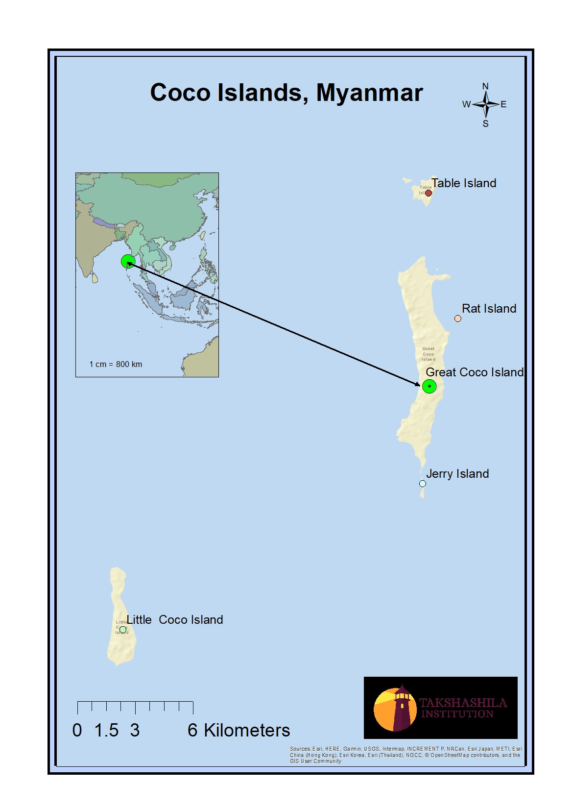
Recent satellite images show that there has been significant military development in the Coco Islands groups. The Coco Islands are popular due to their strategic location, which is directly in line with the Malacca Strait, a vital point for global oil supply routes from the Gulf to the South East and India's key defence establishments to the West. Also, the islands are only 54km from the Indian Military base in Andaman and Nicobar Islands. The Chinese Military is believed to be monitoring the Indian Naval base Visakhapatnam, DRDO's Integrated Test Range facility in Balasore District of Odisha, and more importantly, activities in Malacca Strait through a signal intelligence facility on the island. Having a signal post nearby and a direct line of sight is essential for signal intelligence and eavesdropping on conversations from the other side. Satellite images show a noticeable military presence in different parts of Coco Island groups, including - Slipper Island, Table Island, Great Coco Island, Jerry Island, and Little Coco Island. It's important to note that Little Coco Island is located on the Little Coco Reef, while the other four islands are situated on the Great Coco Reef.
The speculations around the island group are apparent, given the quantum of developmental activities happening in recent years. The construction and operation of such a sophisticated military base far from Yangon City in Myanmar, which Myanmar itself neither needs nor has the financial means to afford, strongly indicates that it may have been clandestinely established and is being operated by China. The Coco Islands remain a fascinating and enigmatic corner of our world, inviting people to explore and uncover their secrets.
Recent speculation
This is not the first time the coco islands have been in the limelight. The place gained prominence and became a concern for the strategic community in India in the early 90s when it was believed that a Chinese signal intelligence facility was established with a 45-50 m antenna tower, radar station and other electronic facilities. Since then, the development activities in this area have been increasing and are getting attention only when high-resolution satellite images are released. A report by Chatham House based on high-resolution Maxar satellite images of January 2023 divulges new construction activity on the Great Coco Island. The report indicates that "Myanmar could conduct naval surveillance operations from Great Coco Island. As stated previously, it is unlikely that the Myanmar Navy could conduct surveillance operations independently. The constructions, such as an extended runway, new hangers, a large pier, and suspicious constructions on this isolated archipelago near a strategic Indian navy outpost, are currently shrouded in mystery".
Military development in the Coco Islands group
A decade's satellite imagery shows a deliberate and continuous construction of military infrastructure on the islands to support all military branches, including the Army, Navy, and Air Force. We conducted a thorough analysis of the islands using remote sensing techniques, leading to various observations that reveal their unique characteristics and features.
A mysterious “radar station”
On top of Great Coco Island, a radar station has been strategically placed at a height of 102 meters above sea level for military purposes. In December 2013, satellite images showed that trees had been cleared and construction was underway. The image of April 2022 indicates that the station has been strengthened and converted into a fully functioning signal intelligence post with a robust military radar infrastructure. With this radar system, the military can monitor and collect information on air and maritime activities within Myanmar's borders, thereby improving their border security and defence capabilities. However, the Chinese may also use this to monitor activities in India's Andaman Nicobar and far away - the western coast of India and Malacca Straight using High-Frequency radar. There are suspicions of cooperation between Myanmar and China in installing this radar, a source of worry for India.

Towards a bigger airbase
Our analysis of satellite imagery of Great Coco Island on Google Earth has revealed significant expansions to the runway and infrastructure. The northern end of the runway was extended between October 2014 and October 2016, resulting in a longer runway of 2.5km instead of 1.5km. Furthermore, the width of the runway was increased from 30m to 50m around 2020 and 2021. An operational hangar of approximately 46m x 45m has been in use since last year, and land has been cleared near the runway, suggesting that additional hangars may be constructed in the future. On the western side of the airstrip, we observed the emergence of several buildings that could support the infrastructure of a military base between 2017 and 2018. Some buildings are guarded with tall walls, indicating they are likely part of a military establishment and not civilian housing. With these expansions, the airbase will be able to house a wide range of modern aircraft, including many Chinese military planes.

The Enigmatic part of the Unseen Coco Island
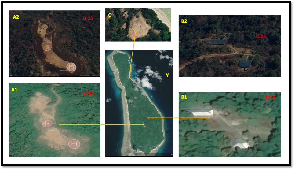
Little Coco Island, located just 15km southwest of Great Coco Island, appeared to be a crucial military hub. Despite being the second largest island in the Coco Islands group, with a length of approximately 5km and a maximum width of 1.3km, it is covered in dense vegetation and lacks any civilian community. The thick coral reefs and dense vegetation surrounding the island make it unsuitable for civilian habitation.
Significantly, two well-maintained helipads with a radius of 7m were discovered next to each other at the highest point of the island and were established in 2017, becoming operational in 2018. Furthermore, two shelters accommodating 100-150 people were found roughly 350m from the helipads. Although the shelter appears old, it might have been operational for up to two decades. In addition, a third helipad was found in the northern plain region of the island, which has been inactive for over a decade. The helipads and shelter are connected well with the road network. The existence of these facilities in such a remote location on the island has sparked speculation regarding potential military activities in the area.

Declining vegetation
The island groups are primarily covered in evergreen forests, which house various species. However, our research indicates that these islands' vegetation has decreased. We utilised time series and open-source Landsat satellite imagery to observe that although there are seasonal changes in vegetation density, the overall health and density of the vegetation cover have been declining. The time series was performed over NDVI (Normalised Difference Vegetation Index). Higher values indicate healthy vegetation, while lower values indicate poor or no vegetation. Despite increasing rainfall over the last thirty years, raising ambient temperature may not be a concern as the place exhibits similar climatic conditions throughout the year and experiences good rainfall except for three months (January, February, and March) in a year. It is essential to note the stark contrast in vegetation cover between Little Coco Island and Great Coco Island. Regrettably, the central region of Little Coco Island has undergone a substantial deterioration in both the quantity and quality of its vegetation, which was once flourishing. The decline is evident in the False Colour Composite (FCC) of Infrared, Red, and Green used in digital image processing to visualise the quality and quantity of vegetation cover. Dark red indicates highly dense vegetation and light red indicates sparse vegetative surface. The reduction in vegetation cover appears to be linked to potential military infrastructure over the years rather than climate change.


Parting Shot
The recent developments in the Great and Little Coco Islands suggest an increased likelihood of extensive military activity. These developments include changes to land cover, deforestation, and the construction of larger airbases, helipads, naval piers, and advanced signal intelligence facilities. Myanmar's relationship with China makes the island group a potential military outpost for China. This would enable China to closely monitor India's nearby military installations and movements in Malacca Strait and the Bay of Bengal.
Our comprehensive examination of the Great and Little Coco Islands has uncovered compelling evidence of an underground facility that may be assisting Chinese submarines. This finding holds significant strategic operational and tactical implications for the Indo-Pacific region. Keep an eye out for our subsequent newsletter, which will provide further details on this crucial topic.
Disclaimer: Please note that the research analysis and interpretation of remote sensing data may vary concerning the algorithm used, level of data processing, analyst skills, and quality of input datasets. The inferences compiled here are limited to the open-source dataset and tools available to the research team.


