#5 Unveiling the dragon's footprint: Geospatial intelligence of recent developments in the Doklam plateau.
TL; DR
PLA continues to expand its presence in the Doklam plateau area, deepening the threat posed to the Siliguri Corridor.
Occupation astride the Mochu River, extending up to 9 kilometres inside territory disputed with Bhutan.
Recent Sino-Bhutan talks on border issues are unlikely to impact China’s de-facto occupation of the Doklam Plateau.
Doklam’s history and assertions
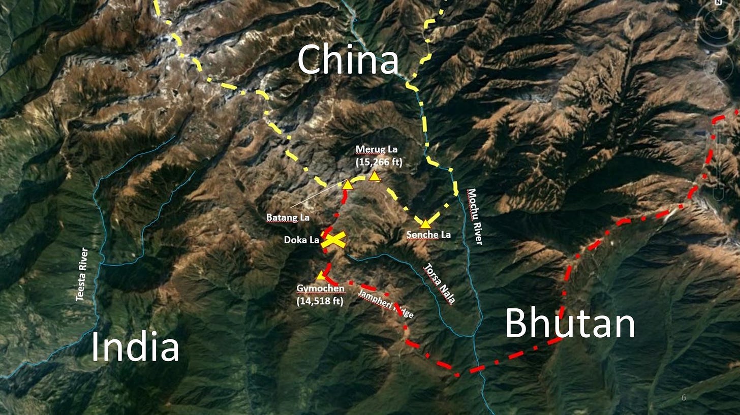
The Doklam tri-junction, a vital region in the Himalayas, has become a focal point of geopolitical tension between India and China, marked by historical complexities and territorial disputes. The issue's roots trace back to geopolitical shifts in the 17th and 18th centuries, shaping the Himalayan landscape and British involvement. The Anglo-Chinese Convention of 1890, a pivotal treaty delineating boundaries, omitted Bhutan as a signatory. The current Doklam border dispute revolves around conflicting interpretations of the treaty and India’s legal rights. China’s low-level patrolling/ civilian herding dates back to 1966, escalating in 2017 when a standoff ensued over a road construction project. Despite de-escalation efforts post-2017, China continued its construction activity.
To comprehensively understand events in the Doklam plateau up to July 2020, encompassing its history and developments, I suggest exploring The Doklam Imbroglio. This detailed resource offers valuable insights into the issue.
In this article, we have examined the recent military advancements undertaken by China’s People’s Liberation Army (PLA) in Doklam, particularly over the past two years, utilising satellite imagery and Geospatial Intelligence as valuable resources.
Recent developments in the Doklam plateau
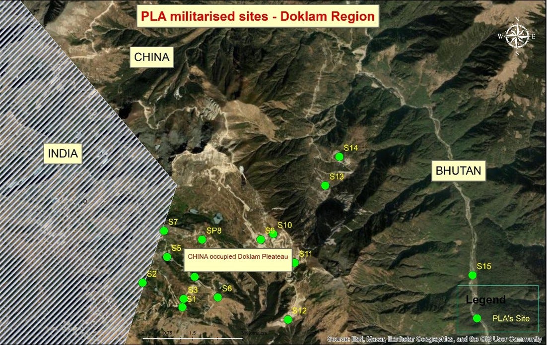
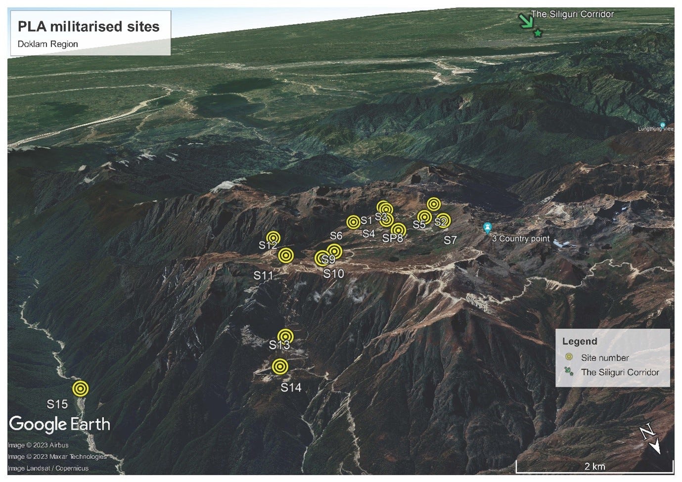
The sites examined in the study are the Chinese-occupied Doklam plateau, which lies north of the Jhampheri ridge, bordered by India’s state of Sikkim in the west and the Mochu River in the east. The mountain peaks of Batang La, Merug La, Senche La, and Mt Gymochen surround this area.
Doklam plateau

Site Number 1 (Figure 4) is located at an elevation of 4,232 meters above sea level on a mountain peak oriented towards the Indian side. It hosts a complex network of military facilities and structures at the peak’s highest point of 4,235 meters. The site is easily reachable via well-established roads that connect it to the surrounding areas, and it is located just under 2 kilometres from the Doklam standoff point. The road connecting the standoff point and site 1 holds several helipads. The PLA made military fortifications on this site, which included solar panels, communication trenches, a communication tower, temporary shelters, and a few gun positions. It is to be noted that the shelters were established after 2019, as indicated by the images from 2017 to 2023.
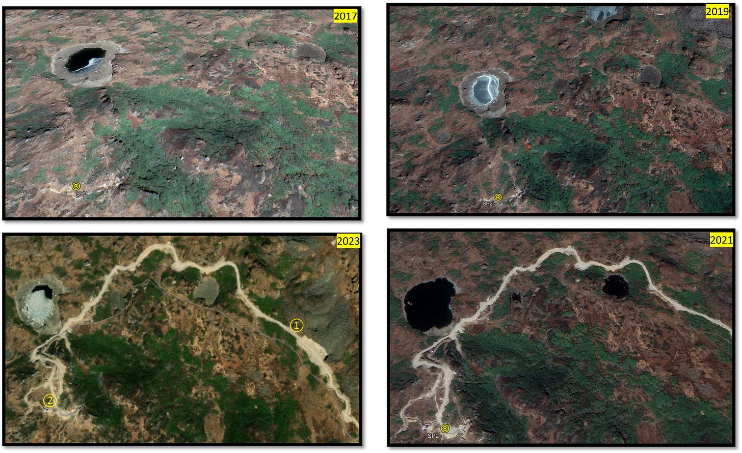
Site No. 2 (Figure 5) is located on the closest mountain slope to the Indian border, with an elevation of 4265 m. It is less than a kilometre from the 2017 standoff site. From the available images, it seems the site has been cleared, and roads have been constructed up to the top of the mountain in 2021. The expansion on this mountaintop has been steady, and an observation post has been set up.
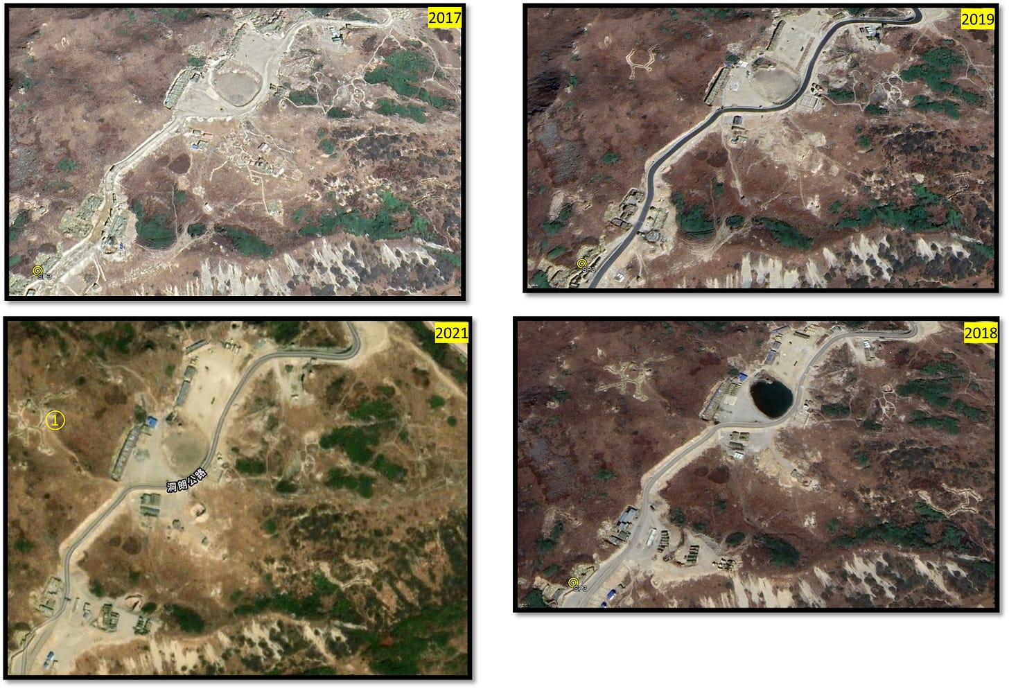
Site number 3 (Figure 6) is adjacent to a roadway traversing the Doklam plateau from the Doklam standoff point. This location features distinct markings, trenches on the east-facing slope, and camouflaged shelters. Notably, this site represents the forward point where military vehicles, gun positions, and supporting sheds exist.
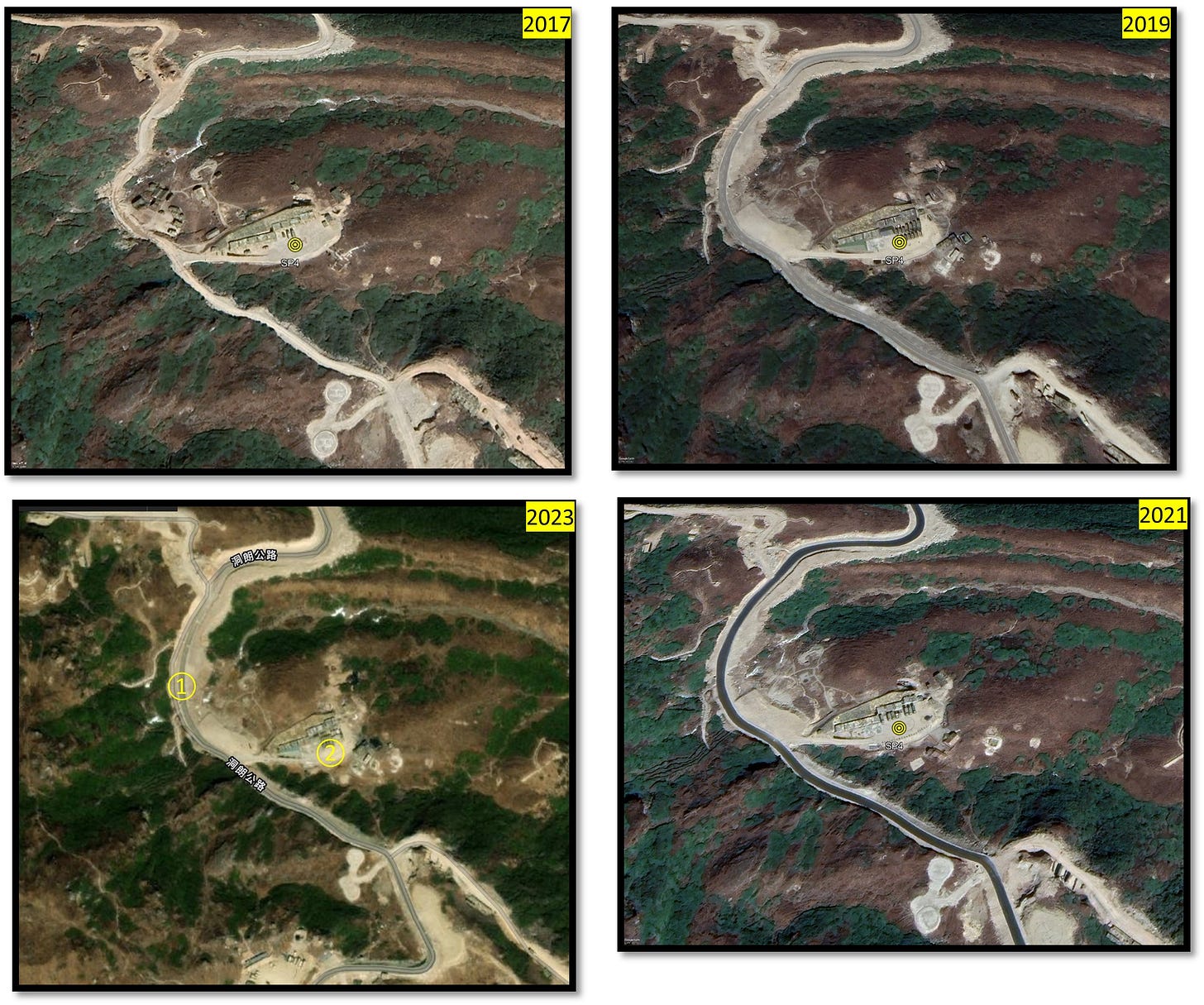
Site number 4 (Figure 7) comprises a structure with numerous vehicles, including a command post where significant activity occurs on the leeward slope. As such, Sites 3 and 4 have developed significantly in recent years, including trenches, gun positions, helipads and other military infrastructure. The infrastructure on either side of the flatland road has remained unchanged since 2017.
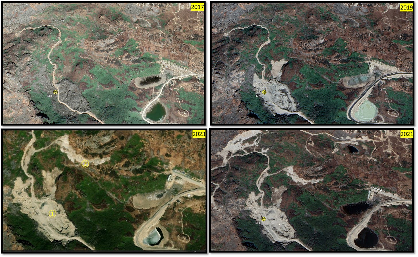
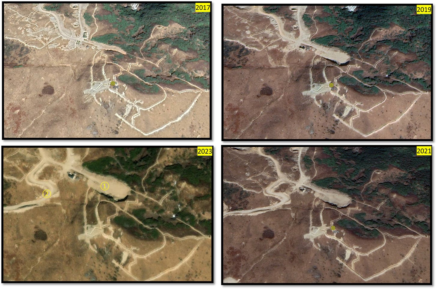
Site 5 (Figure 8) and 6 (Figure 9) are on leeward slopes. Notably, the area has developed significantly since 2019, and the shelters appear camouflaged along the road towards the northeast of Doklam. Site 5 is located at an elevation of 4,235 meters, while Site 6, an extension of Site 5, is at 4,323 meters. Ongoing construction and land reclamation on the mountain slopes suggest continued developments in this area.
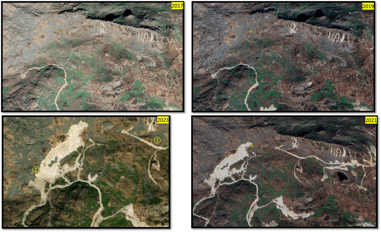
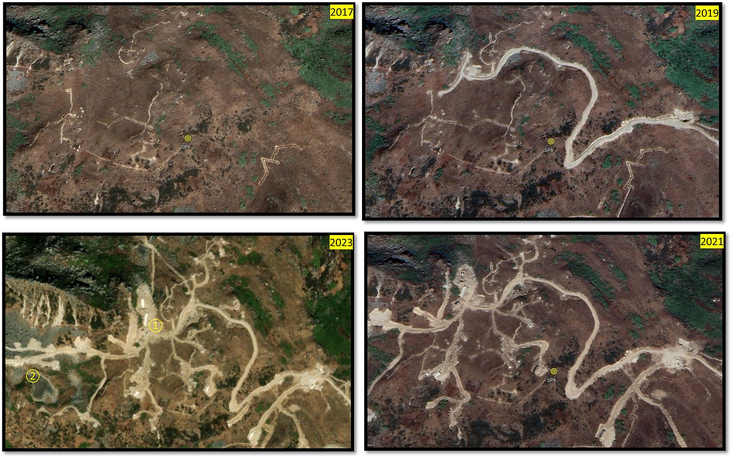
On the same ridge, Site 7 (Figure 10) and Site 8 (Figure 11) are at 4337 and 4318 meters, respectively. Site 7 is undergoing similar activity as Site 5, in which land clearance is being carried out on the slope. Meanwhile, site eight at the top of the mountain has robust road connectivity and numerous gun positions, trenches, and pillboxes. These pillboxes at the summit top provide direct views toward Doka La in the southwest, Merug La in the north, and Senche La in the east. The flat land on the mountaintop, closely linked to Site 8, spans approximately 45 acres.
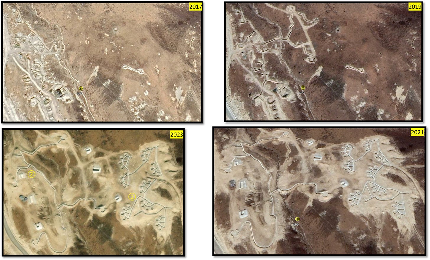
Site 9 (Figure 12) is located at an altitude of 4179 meters and covers an area of approximately 15 acres. It overlooks the Indian Territory. It is only two kilometres from Senche La, less than four kilometres from Batang La and less than five kilometres from the standoff point. In 2021, significant developments occurred at this site, previously limited to trenches and artillery positions on a mountain slope to the left of a road leading from the Standoff point towards the Senche La. Back in 2019, the site had a modest setup, but by 2020 and 2021, the monitoring post underwent a substantial transformation. A relatively flat piece of land at a slightly higher elevation now serves as a potential ammunition dump or a post with a secret underground vault and robust iron doors. This facility, marked with firing loopholes in trenches along the road approaching the standoff point, suggests heightened sensitivity. Notably, developments in this region have been relatively subdued post-2021.
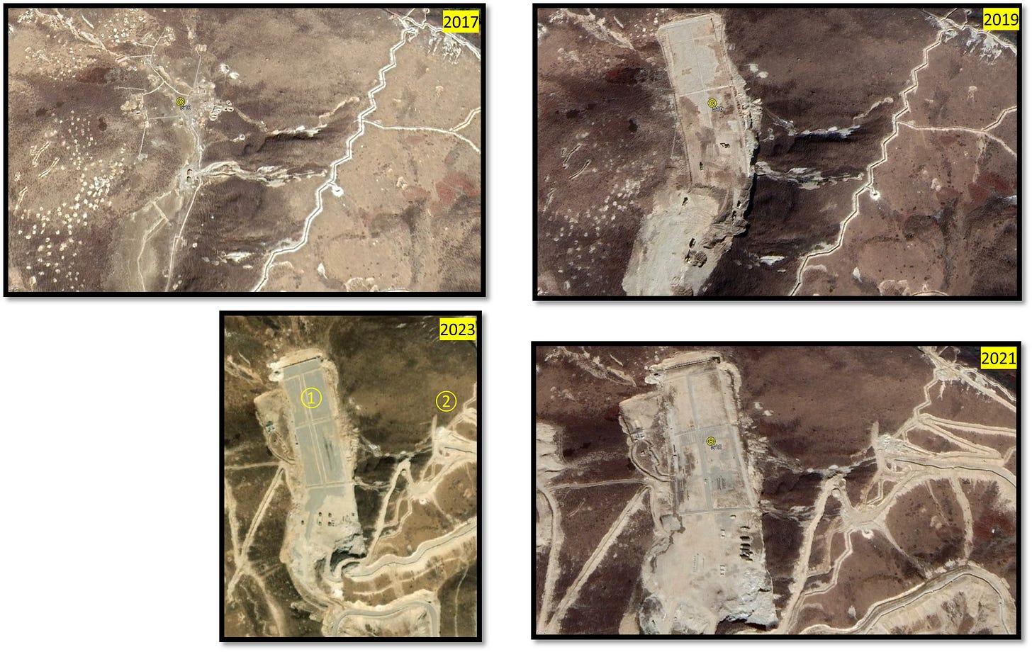
Site 10 (Figure 13), a key location in our study, appears as a focal point of persistent military activity preceding 2017. Situated less than a kilometre from Site 9, this site underwent significant alterations in 2017, evolving into a conclave set of structures just below Senche La, facing south towards Doklam standoff point. The flat terrain, spanning three kilometres and surrounded by mountains, transformed from a slope with artillery and machine gun positions, bunkers, trenches, and firing points on the leeward side in 2017 to a concrete structure in 2019. Site 10 appears to us like a fully functional Forward Area Refuel and Rearm Point (FARRP), closely linked to the ammunition dump at Site 9 and other ongoing activities in Senche La.
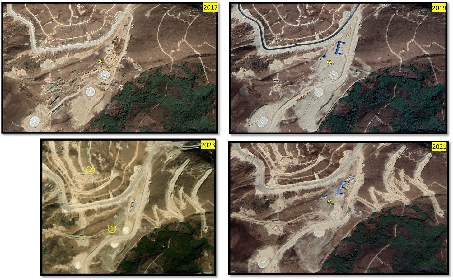
Site 11 (Figure 14) is located at an elevation of 4447 meters. Despite being developed in 2017, the site has remained largely unaltered, featuring three helipads, military vehicles, various structures, and a road leading from Senche La into the valley. However, recent activity has been noticed, including extending the road downhill into the valley, increasing trenching, and other operations on the slope near Senche La.
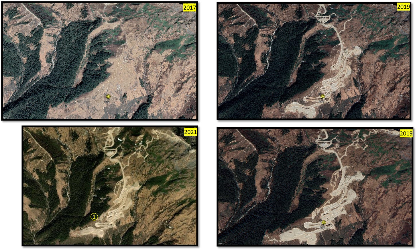
Site 12 (Figure 15) is located on the down slope of the road connecting further from Site 11 towards Niyu, northeast of Torsa Nala. Site 12, developed after 2019, is 3906 meters in a deep valley.
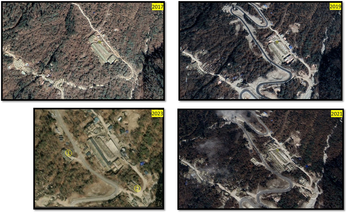
Site 13 (Figure 16) is located north of Senche La, sloping towards the Mochu River. This site has a significant military presence, including military vehicles, communication towers, sheds, permanent structures, and solar panels. The area is tactically sited with a robust infrastructure that blends well with the surrounding vegetation and suggests a remote post.
What is noteworthy about this location is its lower altitude of 3,338 meters, which is hidden from the direct view from India. Site 13’s core buildings and structures have maintained their form for longer, indicating its operational continuity. Additionally, the site has evolved in terms of expanded activities, which adds to its overall significance.
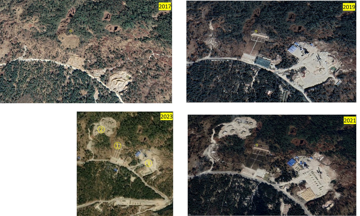
Site 14 (Figure 17) in our study, situated at 3232 meters on the western side of the Mocho River, stands as a hub of extensive military infrastructures. Starting mainly as a barren land in 2017, the site has transformed remarkably into a strategic location featuring towers, a range, complex shelters, and dual-purpose buildings. This place is a focal point for military activity, hosting trenches and bunkers.
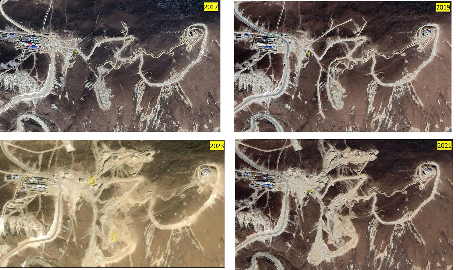
Site 15 (Figure 18) is located at an elevation of 4300m near Yudong County, behind Merug La and Naurang. The site is situated about 9 kilometres away from the Indian border, and its elevated position offers a commanding view of the Indian side from the mountaintop. Similar to Site 14, it is home to essential military infrastructure, including ammunition dumps, helipads, and a potential small military post with parking spaces surrounded by a boundary wall. The site has solar panels for electricity generation and numerous trenches along its mountain slopes. Additionally, it is connected to a well-maintained road leading to Yudong County. The military post and trenches have been on the site since 2017. Still, the development of bunkers gained momentum in the late 2020s, making Site 16 an even more critical infrastructure in our study region.
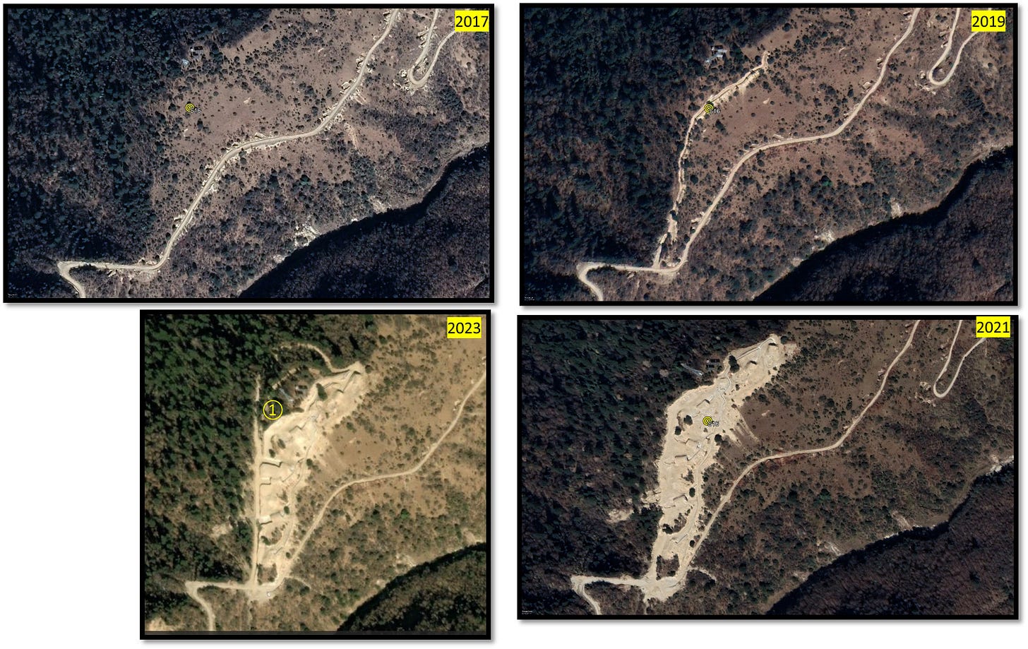
Descending from Site 15, Site 16 (Figure 19) stands at an elevation of 3453 meters on a mountain peak adjacent to a valley inhabited by a substantial civilian population. The foothills of this peak extend to the Mocho River on the eastern side, connecting to Lao Yadong and a valley that leads to Yadong, stemming from Narong. This location holds significance with over 10 ammunition bunkers connected by trenches, easily accessible from the road. Its development in the early 2020s, following the 2017 standoff, is a crucial point.
China’s Intrusions in Bhutan’s Mochu River
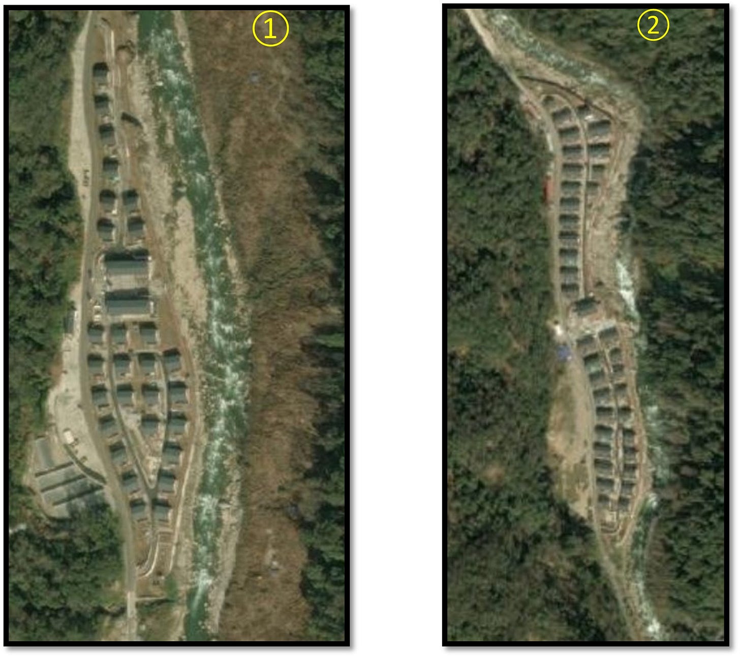
Recent developments along the Mochu River, flowing through Yadong County and entering Bhutan, have sparked concerns due to China’s establishment of villages in the valley. Notably, Pangda village has gained attention as China designates it as a permanent settlement in the region. Construction activity is widespread on the western side of the Mochu River, occurring whenever available land in the valley is identified. Two specific locations showcase the construction of large buildings, villas, and accompanying infrastructure are shown in Figure 20.
Despite the emergence of a village featuring sizable houses, there is uncertainty regarding its purpose. These houses can be used for housing civilians and military purposes. Given its remote location, construction activity persists in the area, extending up to 9 km inside Bhutanese territory.
The attention surrounding developments along the Mochu River stems from concerns about the potential use of an alternate route by PLA troops through the Jhampheri ridge. This route could offer a direct line of sight to India’s Chicken Neck Siliguri Corridor, though the terrain presents significant challenges, with the river flowing north to south. Accessing the Jhampheri ridge would require climbing from 1,700 m to 3,556 m through the challenging Torsa Nalla.
Strategic dialogues: Bhutan’s political negotiations with China and India
Bhutan’s Foreign Minister, Tandi Dorji, made history on October 23, 2023, by becoming the first Bhutanese official to visit China. During the visit, both sides concluded the 25th round of the previously stalled border talks. Chinese Foreign Minister Wang Yi emphasised the importance of establishing diplomatic relations and reaching an agreement on the boundary. This development marks a positive step in strengthening ties between the two nations and resolving border-related issues.
Bhutan’s King Jigme Khesar Namgyel Wangchuck visited India on the 3rd of November, 2023. He reassured Bhutan’s emphasis on India’s concerns and commitment to the India-Bhutan Friendship Treaty and India’s interests will be preserved.
Parting shot
The Doklam tri-junction emerges as a focal point as we navigate through the layers of history, with unresolved issues surrounding Bhutan’s involvement, treaty interpretations, and India’s legal rights in the disputed territory.
Zooming in on recent military advancements, our geospatial analysis reveals China’s extensive footprint in the Doklam region, marked by sites like Site 10, a transformed Forward Area Refuel and Rearm Point (FARRP). This key location and others, such as Site 9, 11, 14, 15, and 16, highlight ongoing developments in the area. China's activities near the Mochu River, such as establishing villages in the valley, raise concerns about their purpose.
Our findings emphasise the need for vigilant monitoring in the Doklam region.
Subscribe to our newsletter https://geospatialbulletin.substack.com for the latest updates on geospatial analysis in this region and locations of strategic interest to India.

